

Alaska and Landsat
Links
- Document: Report (3.15 MB pdf) , HTML , XML
- Version History: Version History (8.30 kB txt)
- Download citation as: RIS | Dublin Core
Abstract
Alaska is the “Last Frontier,” a stunning and dynamic landscape whose rugged beauty has fascinated and thrilled Americans since its acquisition from Russia in 1867 by Secretary of State William Seward. The Arctic lands of the 49th State remain wildly popular tourist destinations, but the State also contributes to the Nation’s energy security through its mineral and energy resources, and is the dominant player in the U.S. seafood industry, yet Alaska’s landscapes are changing at a more rapid rate than those of the lower 48.
Alaska’s large size makes the collection of aerial surveys—a biannual occurrence for the conterminous United States—cost prohibitive. That means the Landsat series of land-imaging satellites offer the only publicly available, up-to-date imagery of land conditions for Alaska. Landsat satellites underpin public and private sector decisions in the State and across the Nation for effective adaptation to changing landscapes. Those decisions often lead to enhanced agricultural productivity, smart urban development, sustainable forest management, inland lake water quality monitoring, increased disaster resilience and risk assessment, effective water use, climate research, and other applications.
Here are just a few examples of how Landsat benefits Alaska.
Land Change and Permafrost Accounting
At 663,268 square miles, Alaska is the largest U.S. State by area. Much of that land is remote, sparsely-populated and difficult to access for field research. Landsat offers a powerful tool for monitoring remote Arctic ecosystems. One USGS-led study determined that 13 percent of the State’s land area—an area larger than the State of Wisconsin—has changed over the past 32 years because of glacial retreat, shrub and tree line expansion, wildfires, erosion, pollution disturbances, and more (Pastick and others, 2019). Landsat was used in 2015 to create a baseline assessment of Alaska’s near-surface permafrost and to project permafrost degradation (Pastick and others, 2015).
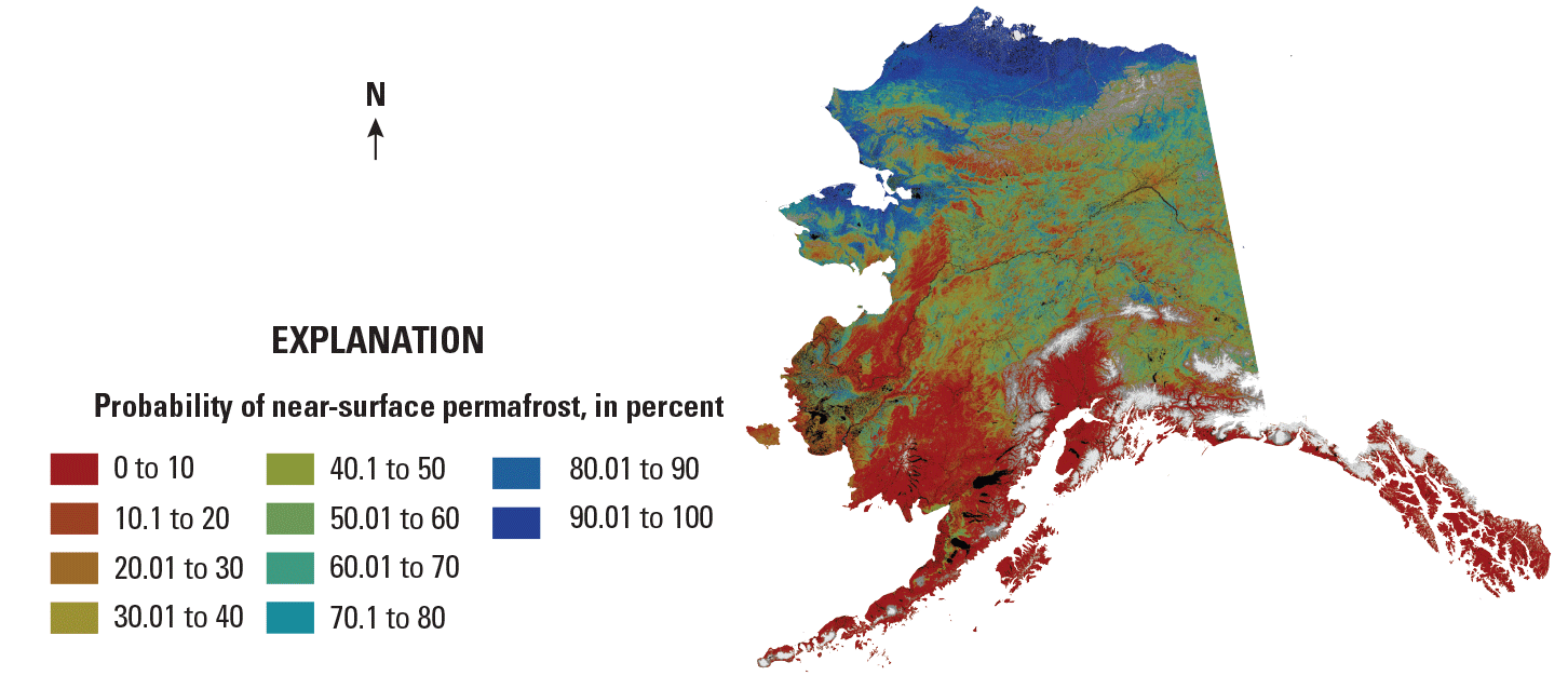
A color-coded map of permafrost distribution for the State of Alaska, created using data from the Landsat satellite program (Pastick and others, 2015).
Coastlines and Fisheries
More 56,000 Alaskans work in the seafood industry, and many thousands more rely on fisheries for food. Understanding changes to coastlines, inland rivers and lakes, and surrounding ecosystems is critical to managing fisheries for both commercial industry and Alaska’s Native population. Landsat’s unparalleled historical archive has helped researchers track the vulnerability of coastlines and subsistence resources in the Kotzebue Sound region (Gorokhovich and others, 2014), model coastal inundation for Cook Inlet (Ezer and Liu, 2010), and map thermal erosion across thousands of lakes in the Noatak National Preserve (Lara and others, 2019)—just to name a few.
Wildfire and Disaster Response
When the Castle Rocks Fire ignited in Denali National Park in July 2013, the Alaska Fire Service turned to Landsat 8 to help build fire perimeter maps (National Park Service, 2021). The agency did the same for the Funny River Fire on the Kenai Peninsula the following year, and for countless fires since then. When flooding closed the Dalton Highway in 2015—the only access road to the Prudhoe Bay oil field—Landsat was used to assess the damage (National Aeronautics and Space Administration, 2015). Landsat’s public imagery database offers emergency managers a cost-effective tool for monitoring and responding to disasters in Alaska.
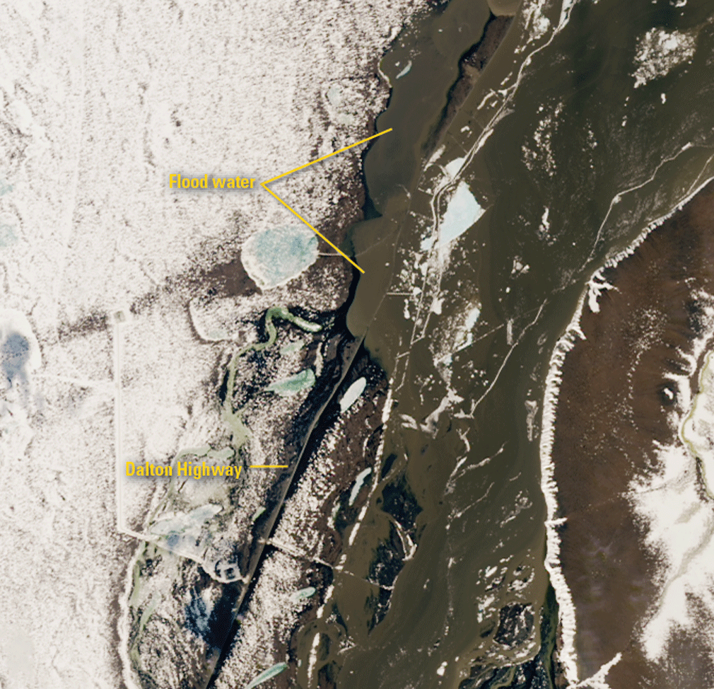
Landsat imagery is valuable for managing natural or human-made disasters. The image on the left shows the Dalton Highway in northern Alaska during major flooding in 2015. The false color image on the right shows the Marr and Little Crazy Mountain Fires of 2019.
National Land Imaging Program Benefits—Alaska
The U.S. Geological Survey (USGS) National Land Imaging Program provides a wide range of satellite imagery and other remotely sensed and geospatial data to Government, commercial, academic, and public users. Those users can get worldwide access to Landsat satellite data through the National Land Imaging Program-funded USGS Earth Resources Observation and Science (EROS) Center.
Landsat—Critical Information Infrastructure for the Nation
Landsat is the most widely used land remote sensing data source within Federal civilian agencies. Local, State, Tribal, and Federal agencies use Landsat to monitor and forecast a wide range of land surface phenomena. Information from Landsat contributes to day-to-day decisions on land, water, and resource use that protect life and property; safeguard the environment; advance science, technology, and education; support climate change resiliency; and grow the U.S. economy. Landsat’s imagery provides a landscape-level view of land surface, inland lake, and coastal processes, both natural and human-induced. Landsat enables us to better understand the scope, nature, and speed of change to the natural and built environment.
Businesses draw upon Landsat data to provide customer-specific applications to improve logistics, resource allocation, and investment decisions. Commercial space imaging firms leverage Landsat data to refine product offerings and support new information services. A 2017 USGS study determined the total annual economic benefit of Landsat data in the United States to be $2.06 billion, far surpassing its development and operating costs (Straub and others, 2019).
Landsat 8 and Landsat 9 provide 8-day repeat coverage of the Earth’s land surfaces. The National Aeronautics and Space Administration (NASA) and the USGS are currently reviewing the findings from a joint Architecture Study Team, which will inform the design and implementation approach for Landsat Next, the follow-on mission to Landsat 9. Landsat 9 and its successors are planned to provide a sustainable, space-based system to extend the 50-year Landsat series of high-quality global land imaging measurements—the world’s longest time series of the Earth’s land surface.
The long-term availability of consistent and accurate Landsat data, combined with a no-cost data policy, allows users to analyze extensive geographic areas and to better understand and manage long-term trends in land surface change. New cloud computing and data analytics technologies use Landsat data in a wide range of decision-support tools for Government and industry. Much like global positioning system and weather data, Landsat data are used every day to help us better understand our dynamic planet.
References Cited
Ezer, T., and Liu, H., 2010, On the dynamics and morphology of extensive tidal mudflats—Integrating remote sensing data with an inundation model of Cook Inlet, Alaska: Ocean Dynamics, v. 60, no. 5, p. 1307–1318. [Also available at https://doi.org/10.1007/s10236-010-0319-x.]
Gorokhovich, Y., Leiserowitz, A., and Dugan, D., 2014, Integrating coastal vulnerability and community-based subsistence resource mapping in northwest Alaska: Journal of Coastal Research, v. 30, no. 1, p. 158–169. [Also available at https://doi.org/10.2112/JCOASTRES-D-13-00001.1.]
Lara, M.J., Chipman, M.L., and Hu, F.S., 2019, Automated detection of thermoerosion in permafrost ecosystems using temporally dense Landsat image stacks: Remote Sensing of Environment, v. 221, p. 462–473. [Also available at https://doi.org/10.1016/j.rse.2018.11.034.]
National Aeronautics and Space Administration, 2015, Flooding of Dalton Highway: National Aeronautics and Space Administration web page, accessed January 29, 2020, at https://landsat.visibleearth.nasa.gov/view.php?id=85905.
National Park Service, 2021, Landsat 8 helps map fires during long, busy Alaska fire season: National Park Service web page, accessed November 28, 2022, at https://www.nps.gov/articles/wildland-fire-landsat-8-helps-map-fires-alaska.htm.
Pastick, N.J., Jorgenson, M.T., Goetz, S.J., Jones, B.M., Wylie, B.K., Minsley, B.J., Genet, H., Knight, J.F., Swanson, D.K., and Jorgenson, J.C., 2019, Spatiotemporal remote sensing of ecosystem change and causation across Alaska: Global Change Biology, v. 25, no. 3, p. 1171–1189. [Also available at https://doi.org/10.1111/gcb.14279.]
Pastick, N.J., Jorgenson, M.T., Wylie, B.K., Nield, S.J., Johnson, K.D., and Finley, A.O., 2015, Distribution of near-surface permafrost in Alaska—Estimates of present and future conditions: Remote Sensing of Environment, v. 168, p. 301–315. [Also available at https://doi.org/10.1016/j.rse.2015.07.019.]
Straub, C.L., Koontz, S.R., and Loomis, J.B., 2019, Economic valuation of Landsat imagery: U.S. Geological Survey Open-File Report 2019–1112, 13 p., accessed April 8, 2022, at https://doi.org/10.3133/ofr20191112.
For additional information on Landsat, please contact:
Program Coordinator
USGS National Land Imaging Program
12201 Sunrise Valley Drive
Reston, VA 20192
703–648–4567
The Landsat series is a joint effort of USGS and NASA. NASA develops and launches the spacecraft; USGS manages satellite operations, ground reception, data archiving, product generation, and data distribution. Funding for the National Land Imaging Program’s Landsat operations and data management is provided through the USGS.
Suggested Citation
U.S. Geological Survey, 2020, Alaska and Landsat (ver. 1.1, December 2022): U.S. Geological Survey Fact Sheet 2020–3068, 2 p., https://doi.org/10.3133/fs20203068.
ISSN: 2327-6932 (online)
ISSN: 2327-6916 (print)
Study Area
| Publication type | Report |
|---|---|
| Publication Subtype | USGS Numbered Series |
| Title | Alaska and Landsat |
| Series title | Fact Sheet |
| Series number | 2020-3068 |
| DOI | 10.3133/fs20203068 |
| Edition | Version 1.0: December 21, 2020; Version 1.1: December 12, 2022 |
| Year Published | 2020 |
| Language | English |
| Publisher | U.S. Geological Survey |
| Publisher location | Reston, VA |
| Contributing office(s) | Earth Resources Observation and Science (EROS) Center |
| Description | 2 p. |
| Country | United States |
| State | Alaska |
| Online Only (Y/N) | N |
| Google Analytic Metrics | Metrics page |