

New York and Landsat
Links
- Document: Report (5.26 MB pdf) , HTML , XML
- Version History: Version History (4.01 kB txt)
- Download citation as: RIS | Dublin Core
Abstract
From the iconic skyline of New York City to the forested landscapes of the Adirondack Mountains and the countryside of the Allegheny Plateau, the State of New York is overflowing with diversity and life. Bordered by the Atlantic Ocean on the east and two of the Great Lakes to the north and west, New York has more than 7,600 lakes, ponds, and reservoirs and more than 70,000 miles of rivers and streams. New York’s stewardship of its freshwater resources is fundamental to the health and well-being of all who work at, reside in, and visit the State’s landmarks and places.
Harmful algal blooms (HABs) in the State’s waterbodies are a growing concern and threaten the health of the region and its inhabitants. Images and data from Landsat satellites continue to provide critical information to scientists, public health officials, and resource managers who are studying the effects and risks of the problem.
Here is a closer look at just a few examples of the value of Landsat to New York.
Urban Heat Equality Mapping
The New York City Council recently used Landsat 8 data to map relative summer temperatures to see which parts of the city are hotter than others. Urban heat islands, where daytime and nighttime temperatures are higher and air pollution helps trap heat, can contribute to health problems and even deaths. The City Council aims to help residents in the warmer neighborhoods, largely in Brooklyn and Queens, with cooling programs in homes and centers. Future heat waves could result in fewer deaths and illnesses because of these cooling programs. As climate change raises temperatures, these efforts will become even more important (New York City Council, 2020).
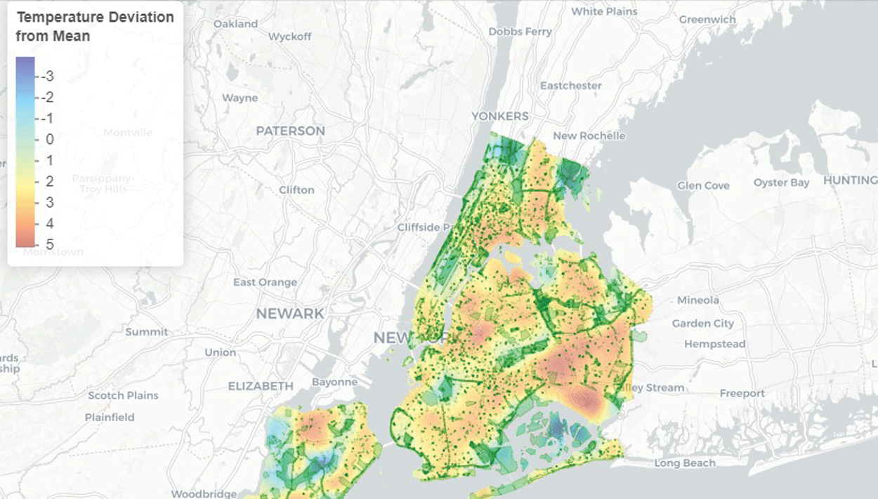
The New York City Council’s Data Team used Landsat 8 data to create an interactive map showing temperature differences throughout the city. Image credit: New York City Council; used with permission.
Harmful Algal Bloom Action Plans
New York State Department of Environmental Conservation recognizes how crucial protecting water quality is to the health and well-being of its people and its ecosystems. Its Water Quality Rapid Response Team used Landsat 8 data to help map HABs on 12 priority lakes throughout the State. The satellite imagery from 2015 to 2017 helped in estimating the concentration of chlorophyll-a, a pigment indicative of algae, in the lakes. The Water Quality Rapid Response Team then collaborated with experts and local stakeholders to develop HAB action plans for the lakes that address contributing factors such as phosphorus pollution. Authorities can use knowledge gained from these 12 lakes to help protect other threatened lakes across the State (New York State Department of Environmental Conservation, 2021).
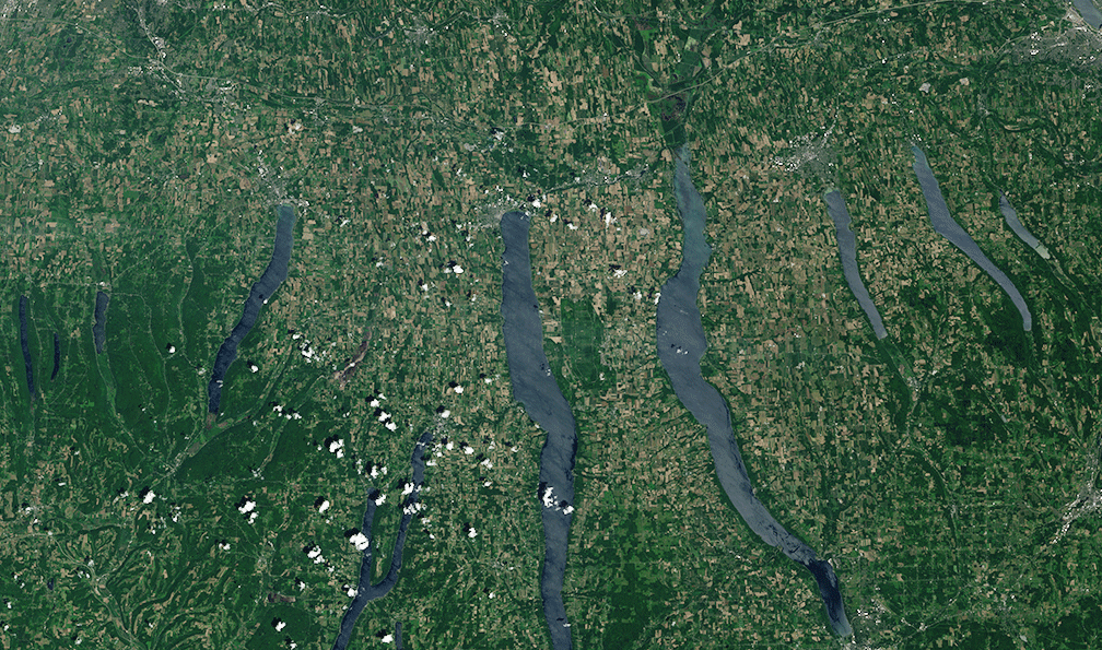
This June 2018 Landsat scene shows the Finger Lakes region in New York below Lake Ontario. Action plans to address harmful algal blooms on 12 priority lakes in New York include five of the Finger Lakes.
Invasive Species in Hemlock Trees
Scientists used imagery from Landsat 8 to map eastern hemlock stands in Upstate New York. Hemlock woolly adelgid, an invasive species, has been spreading through eastern hemlock stands in States along the east coast, killing the conifers. Although two regions in New York—Adirondack Park and Tug Hill State Forest—traditionally had been considered too cold for the hemlock woolly adelgid to survive, they are also considered at risk of infestation. This mapping helps partners, including the New York State Department of Environmental Conservation, develop risk models and preventative programs for additional at-risk areas (NASA, 2017). Satellite surveillance also can help agencies track changes in currently infested tree stands, including a recent discovery in an Adirondack campground (Arnold, 2020).

An infestation of hemlock woolly adelgid. Photograph credit: U.S. Department of Agriculture Forest Service, Bugwood.org; used with permission.
National Land Imaging Program Benefits—New York
The U.S. Geological Survey (USGS) National Land Imaging Program provides a wide range of satellite imagery and other remotely sensed and geospatial data to Government, commercial, academic, and public users. Those users can get worldwide access to Landsat satellite data through the National Land Imaging Program-funded USGS Earth Resources Observation and Science (EROS) Center.
Landsat—Critical Information Infrastructure for the Nation
Landsat is the most widely used land remote sensing data source within Federal civilian agencies. Local, State, Tribal, and Federal agencies use Landsat to monitor and forecast a wide range of land surface phenomena. Information from Landsat contributes to day-to-day decisions on land, water, and resource use that protect life and property; safeguard the environment; advance science, technology, and education; support climate change resiliency; and grow the U.S. economy. Landsat’s imagery provides a landscape-level view of land surface, inland lake, and coastal processes, both natural and human-induced. Landsat enables us to better understand the scope, nature, and speed of change to the natural and built environment.
Businesses draw upon Landsat data to provide customer-specific applications to improve logistics, resource allocation, and investment decisions. Commercial space imaging firms leverage Landsat data to refine product offerings and support new information services. A 2017 USGS study determined the total annual economic benefit of Landsat data in the United States. to be $2.06 billion, far surpassing its development and operating costs (Straub and others, 2019).
Landsat 8 and Landsat 9 provide 8-day repeat coverage of the Earth’s land surfaces. The National Aeronautics and Space Administration (NASA) and the USGS are currently reviewing the findings from a joint Architecture Study Team, which will inform the design and implementation approach for Landsat Next, the follow-on mission to Landsat 9. Landsat 9 and its successors are planned to provide a sustainable, space-based system to extend the 50-year Landsat series of high-quality global land imaging measurements—the world’s longest time series of the Earth’s land surface.
The long-term availability of consistent and accurate Landsat data, combined with a no-cost data policy, allows users to analyze extensive geographic areas and better understand and manage long-term trends in land surface change. New cloud computing and data analytics technologies use Landsat data in a wide range of decision-support tools for Government and industry. Much like global positioning systems and weather data, Landsat data are used every day to help us better understand our dynamic planet.
References Cited
Arnold, C., 2020, Satellite technology to be used to combat spread of hemlock wooly adelgid: Glens Falls (New York) Post-Star web page, accessed April 2021 at https://poststar.com/news/local/satellite-technology-to-be-used-to-combat-spread-of-hemlock-woolly-adelgid/article_bda05473-0abd-5ad9-95c2-7fca12e108a0.html.
National Aeronautics and Space Administration [NASA], 2017, Utilizing NASA Earth Observations to map eastern hemlock for hemlock wooly adelgid management in Adirondack Park and Tug Hill State Forest, New York: National Aeronautics and Space Administration Develop web page, accessed April 2021 at https://develop.larc.nasa.gov/2017/spring/NewYorkEco.html.
New York City Council, 2020, Heat and cooling equity: New York City Council web page, accessed April 2021 at https://council.nyc.gov/data/heat/.
New York State Department of Environmental Conservation, 2021, Harmful algal bloom (HAB) action plans: New York State Department of Environmental Conversation web page, accessed April 2021 at https://www.dec.ny.gov/chemical/113733.html.
Straub, C.L., Koontz, S.R., and Loomis, J.B., 2019, Economic valuation of Landsat imagery: U.S. Geological Survey Open-File Report 2019–1112, 13 p. [Also available at https://doi.org/10.3133/ofr20191112.]
For additional information on Landsat, please contact:
Program Coordinator
USGS National Land Imaging Program
12201 Sunrise Valley Drive
Reston, VA 20192
703–648–4567
The Landsat series is a joint effort of USGS and NASA. NASA develops and launches the spacecraft; USGS manages satellite operations, ground reception, data archiving, product generation, and data distribution. Funding for the National Land Imaging Program’s Landsat operations and data management is provided through the USGS.
Suggested Citation
U.S. Geological Survey, 2021, New York and Landsat (ver. 1.1, January 2023): U.S. Geological Survey Fact Sheet 2021–3020, 2 p., https://doi.org/10.3133/fs20213020.
ISSN: 2327-6932 (online)
ISSN: 2327-6916 (print)
Study Area
| Publication type | Report |
|---|---|
| Publication Subtype | USGS Numbered Series |
| Title | New York and Landsat |
| Series title | Fact Sheet |
| Series number | 2021-3020 |
| DOI | 10.3133/fs20213020 |
| Edition | Version 1.0: April 26, 2021; Version 1.1: January 23, 2023 |
| Year Published | 2021 |
| Language | English |
| Publisher | U.S. Geological Survey |
| Publisher location | Reston, VA |
| Contributing office(s) | Earth Resources Observation and Science (EROS) Center |
| Description | 2 p. |
| Country | United States |
| State | New York |
| Online Only (Y/N) | N |
| Google Analytic Metrics | Metrics page |