

Vermont and Landsat
Links
- Document: Report (2.06 MB pdf) , HTML , XML
- Version History: Version History (4.65 kB txt)
- Download citation as: RIS | Dublin Core
Abstract
The Green Mountain State of Vermont is known for its vast swaths of deciduous forest, patches of evergreen, and the Green Mountains that run through its center. Its abundance of maple trees helps explain why the word “Vermont” on a bottle of pure maple syrup amounts to a gold star seal of approval and why 36 percent of the Nation’s maple syrup comes from Vermont. The State’s hiking and ski trails that crisscross its snowy peaks and uncluttered landscapes, meanwhile, explain its popularity as a refuge for recreation.
The land, industries, and people of Vermont are more complex and diverse than its syrup and slopes might suggest. Around 65 percent of Vermont’s agricultural economy is linked to the dairy industry (University of Arkansas System, 2021). Vermont is also a production leader in apples, honey, and Christmas trees, and is one of the largest hay producers in New England.
The waters of Lake Champlain, Lake George, and the Hudson River are also defining features in Vermont, offering transportation corridors, feeding fertile soils, and supporting recreation. Vermont’s water bodies join its snowy peaks as draws for tourism, which generates around $3 billion in annual revenue (Jones, 2018).
Valuable insight into the forests and landscape features of Vermont can be gleaned from the 50-year historical record of Landsat satellite imagery. The archive is accessible at no cost to researchers, land managers, and the public thanks to the open data policy of the USGS National Land Imaging (NLI) Program.
Read on for some examples of how the Landsat program benefits Vermont.
Assessing Forest Health
Landsat satellites collect data across multiple bands of the electromagnetic spectrum, including the infrared and near-infrared bands beyond the visible range of the human eye. As such, the orbiters can capture and catalog the sometimes-invisible damage to forests from fires, diseases, or invasive insects, and can do so across broad swaths of land where on-the-ground surveying is physically difficult, dangerous, or cost prohibitive. Landsat’s long record over time helps scientists establish baselines for forest health and project future trends. Researchers have long recognized Landsat’s ongoing value to Vermont’s forests, from a 1988 coniferous forest damage assessment (Vogelmann and Rock, 1988) to a 2020 projection of future forest composition in southeastern Vermont that could offer management strategies in the face of a changing climate (Nevins and others, 2021).
Tracking Algal Blooms
The same imaging capabilities that enable Landsat to tease out damage to the leaves of hemlock and maple trees can detect the chlorophyll of algae in bodies of water. These capabilities make Landsat a useful tool for tracking blooms of harmful cyanobacteria in Vermont’s lakes and rivers. Such blooms pose a threat to aquatic ecosystems and to human health. Landsat can capture imagery of these blooms from more than 400 miles above the surface. Combining this imagery with on-the-ground survey data—as researchers did for a 2020 study on cyanobacteria distribution in Lake Champlain—can help map the location and frequency of blooms and inform decisions on how to mitigate the effect (Isenstein and others, 2020).
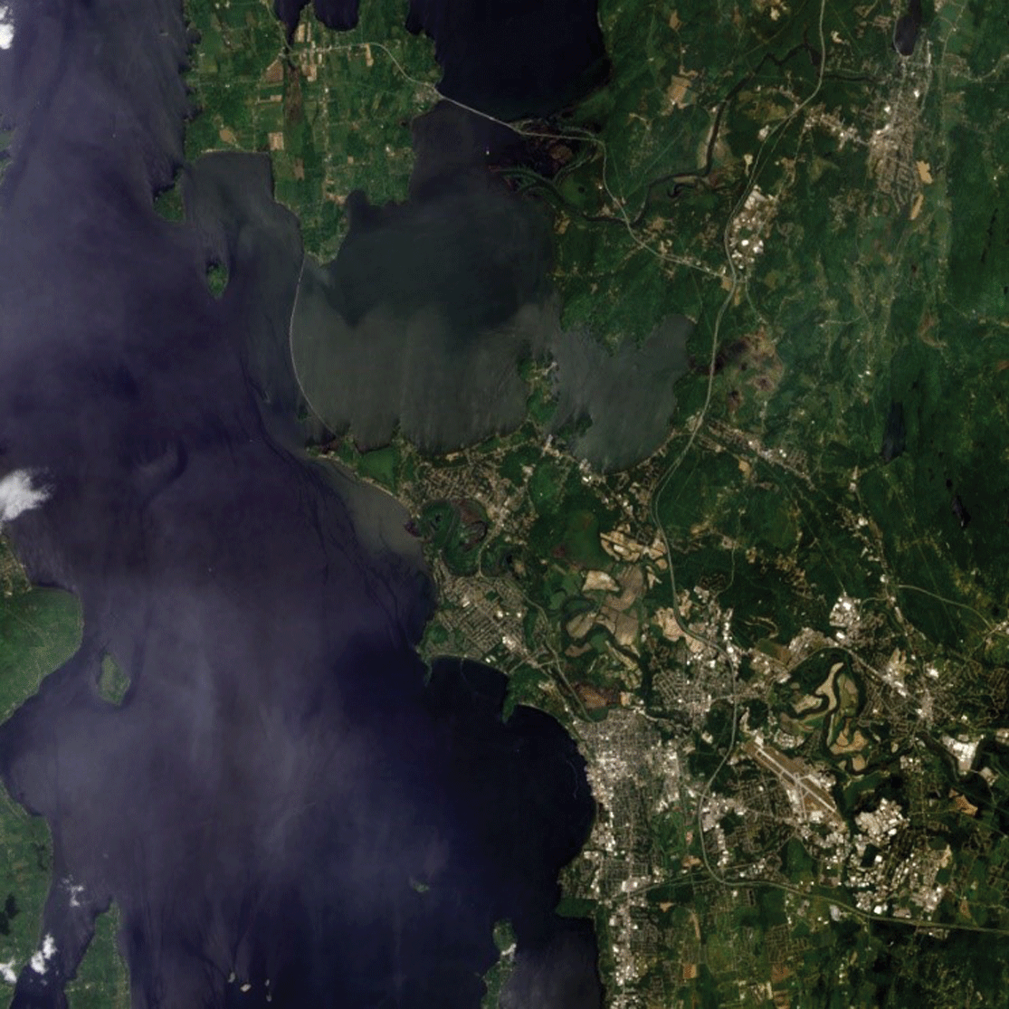
Landsat 8 image of Burlington, Vermont, and Lake Champlain, captured on June 1, 2013. The image shows swirls of cloudy green algae in the lake. Landsat imagery is useful in tracking algal blooms across the United States, including in Vermont.
Vermont Agriculture and Land Use
The multi-agency partnership known as the Lake Champlain Basin Program (LCBP) has used Landsat data to map and monitor the watershed. To help assess changes and trends in land use across the basin (Troy and others, 2007), the program used modified data from the National Land Cover Database (NLCD), a Landsat-based mapping project that assigns a land-cover class (pasture, developed, cropland, deciduous forest, and the like) to each 30- by 30-meter plot of ground in the Nation. The U.S. Department of Agriculture (USDA) also leans on Landsat imagery to help build its National Agricultural Statistics Service (NASS) Cropland Data Layer, an interactive geographic information system tool that shows the crops grown annually in every U.S. State.
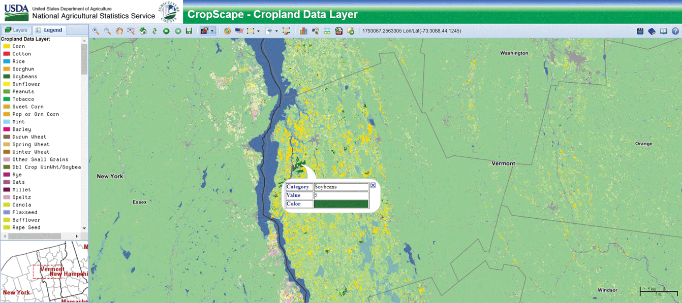
Screenshot of USDA NASS CropScape tool. NASS uses Landsat data to map the crops grown in the United States year after year, which can help identify trends.
National Land Imaging Program Benefits—Vermont
The U.S. Geological Survey (USGS) National Land Imaging Program provides a wide range of satellite imagery and other remotely sensed and geospatial data to Government, commercial, academic, and public users. Those users can get worldwide access to Landsat satellite data through the National Land Imaging Program-funded USGS Earth Resources Observation and Science (EROS) Center.
Landsat—Critical Information Infrastructure for the Nation
Landsat is the most widely used land remote sensing data source within Federal civilian agencies. Local, State, Tribal, and Federal agencies use Landsat to monitor and forecast a wide range of land surface phenomena. Information from Landsat contributes to day-to-day decisions on land, water, and resource use that protect life and property; safeguard the environment; advance science, technology, and education; support climate change resiliency; and grow the U.S. economy. Landsat’s imagery provides a landscape-level view of land surface, inland lake, and coastal processes, both natural and human-induced. Landsat enables us to better understand the scope, nature, and speed of change to the natural and built environment.
Businesses draw upon Landsat data to provide customer-specific applications to improve logistics, resource allocation, and investment decisions. Commercial space-imaging firms leverage Landsat data to refine product offerings and support new information services. A 2017 USGS study determined the total annual economic benefit of Landsat data in the United States to be $2.06 billion, far surpassing its development and operating costs (Straub and others, 2019).
Landsat 8 and Landsat 9 provide 8-day repeat coverage of the Earth’s land surfaces. The National Aeronautics and Space Administration (NASA) and the USGS are currently reviewing the findings from a joint Architecture Study Team, which will inform the design and implementation approach for Landsat Next, the follow-on mission to Landsat 9. Landsat 9 and its successors are planned to provide a sustainable, space-based system to extend the 50-year Landsat series of high-quality global land imaging measurements—the world’s longest time series of the Earth’s land surface.
The long-term availability of consistent and accurate Landsat data, combined with a no-cost data policy, allows users to analyze extensive geographic areas and better understand and manage long-term trends in land surface change. New cloud computing and data analytics technologies use Landsat data in a wide range of decision-support tools for Government and industry. Much like global positioning systems and weather data, Landsat data are used every day to help us better understand our dynamic planet.
References Cited
Isenstein, E.M., Kim, D., and Park, M.-H., 2020, Modeling for multi-temporal cyanobacterial bloom dominance and distributions using Landsat imagery: Ecological Informatics, v. 59. [Also available at https://doi.org/10.1016/j.ecoinf.2020.101119.]
Jones, K., 2018, 2017 benchmark report—Tourism in Vermont: Vermont Department of Tourism and Marketing, 20 p., accessed May 28, 2021, at https://accd.vermont.gov/sites/accdnew/files/documents/VDTM/BenchmarkStudy/VDTM-Research-2017BenchmarkStudyFullReport.pdf.
Nevins, M.T., D’Amato, A.W., and Foster, J.R., 2021, Future forest composition under a changing climate and adaptive forest management in southeastern Vermont, USA: Forest Ecology and Management, v. 479. [Also available at https://doi.org/10.1016/j.foreco.2020.118527.]
Straub, C.L., Koontz, S.R., and Loomis, J.B., 2019, Economic valuation of Landsat imagery: U.S. Geological Survey Open-File Report 2019–1112, 13 p. [Also available at https://doi.org/10.3133/ofr20191112.]
Troy, A., Wang, D., Capen, D., O’Neil Dunne, J., and MacFaden, S., 2007, Updating the Lake Champlain Basin land use data to improve prediction of phosphorus loading: Lake Champlain Basin Program, Technical Report 54, accessed May 28, 2021, at http://www.lcbp.org/techreportPDF/54_LULC-Phosphorus_2007.pdf.
University of Arkansas System, 2021, Vermont economic contribution and impact research: University of Arkansas System Division of Agriculture Research & Extension web page, accessed May 28, 2021, at https://economic-impact-of-ag.uark.edu/vermont/.
Vogelmann, J.E., and Rock, B.N., 1988, Assessing forest damage in high-elevation coniferous forests in Vermont and New Hampshire using thematic mapper data: Remote Sensing of Environment, v. 24, no. 2, p. 227–246. [Also available at https://doi.org/10.1016/0034-4257(88)90027-2.]
For additional information on Landsat please contact:
Program Coordinator
USGS National Land Imaging Program
12201 Sunrise Valley Drive
Reston, VA 20192
703–648–5953
The Landsat series is a joint effort of USGS and NASA. NASA develops and launches the spacecraft; USGS manages satellite operations, ground reception, data archiving, product generation, and data distribution. Funding for the National Land Imaging Program’s Landsat operations and data management is provided through the USGS.
Suggested Citation
U.S. Geological Survey, 2021, Vermont and Landsat (ver. 1.1, February 2023): U.S. Geological Survey Fact Sheet 2021–3038, 2 p., https://doi.org/10.3133/fs20213038.
ISSN: 2327-6932 (online)
ISSN: 2327-6916 (print)
Study Area
| Publication type | Report |
|---|---|
| Publication Subtype | USGS Numbered Series |
| Title | Vermont and Landsat |
| Series title | Fact Sheet |
| Series number | 2021-3038 |
| DOI | 10.3133/fs20213038 |
| Edition | Version 1.0: August 3, 2021; Version 1.1: February 17, 2023 |
| Year Published | 2021 |
| Language | English |
| Publisher | U.S. Geological Survey |
| Publisher location | Reston, VA |
| Contributing office(s) | Earth Resources Observation and Science (EROS) Center |
| Description | 2 p. |
| Country | United States |
| State | Vermont |
| Online Only (Y/N) | N |
| Google Analytic Metrics | Metrics page |