

Florida and Landsat
Links
- Document: Report (2.50 MB pdf) , HTML , XML
- Version History: Version History (2 kB txt)
- Download citation as: RIS | Dublin Core
Abstract
More than 21 million people call Florida home, but many more visit the peninsula each year—including a record 131 million in 2019. Residents and tourists enjoy the State’s warm weather and varied attractions amid incredibly diverse biological and natural resources. Numerous lakes and rivers, and 8,400 miles of ocean shoreline, play a prominent role, as do unique habitats like the Everglades, which are home to protected species such as the Florida manatee (Trichechus manatus latirostris), American crocodile (Crocodylus acutus), and Florida panther (Puma concolor couguar). The State also supports cattle, sugarcane, and citrus production—along with nearly one-half of the tree species in the United States.
A changing climate is expected to bring rising sea levels and more extreme weather events. In a State where the average elevation is 100 feet above sea level, climate change could affect everything from urban shores and beaches to agriculture and forests. In addition, as cities grow, more land cover tends to shift from natural vegetation to impervious surfaces such as pavement, which can add to environmental risks such as flooding.
Landsat can help Florida’s agencies, organizations, and residents monitor the State’s fragile landscapes and plan for a resilient future. Here are just a few examples of how Landsat benefits Florida.
Mapping Fire History Across the State
Land managers in Florida use prescribed burns to help prevent fire fuel buildup and maintain the State’s native vegetation for species dependent on it; the Florida Forest Service issues permits to burn more than two million acres annually. Land managers—public and private—can benefit from knowing the extent and timing of past fires to make decisions about future fuel treatment and prescribed burns. Recent research addresses that need Florida-wide. Scientists from the USGS and Florida’s Tall Timbers research station used the Landsat Burned Area product from 2006 to 2018, along with other information, to map the history and perimeter of fires of various sizes and ownerships across the State (Teske and others, 2021).
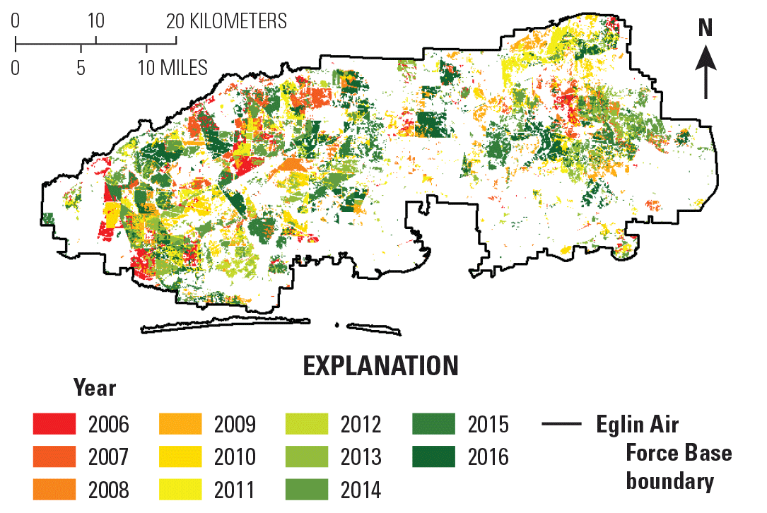
This Landsat-derived example of fire mapping across Florida shows when and where a fire was detected between 2006 and 2016 on Eglin Air Force Base, Florida. Image credit: Teske and others, 2021; used with permission.
Keeping an Eye on the Everglades
University and Federal researchers have used Landsat’s archive to study hurricane damage to mangroves in Everglades National Park. Imagery can reveal the extent of the damage and the length of time it takes for an area to either recover to its prior state or be replaced by open water. One study using Landsat found that a trend of decreasing outer coastline mangroves from 1985 to 2017 was more than offset by increases in inner coastline mangroves. Each hurricane during that timeframe caused damage, but the amount of damage varied by wind factors. Such studies can support effective decisions about ecosystem management and restoration (Han and others, 2018).
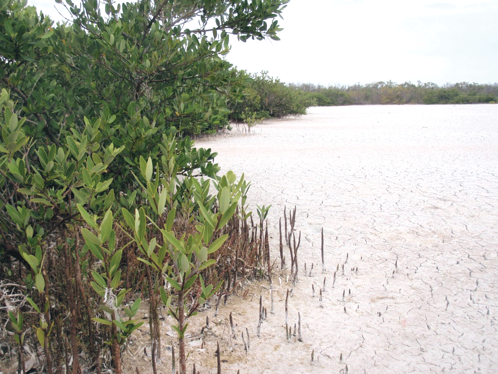
Mangroves grow along Florida Bay. Photograph credit: U.S. Geological Survey.
Addressing a Changing Climate in Miami Beach
NASA DEVELOP Program researchers used data from several Landsat satellites to provide information to the Miami Beach Public Works Department to mitigate climate change effects in Biscayne Bay, including reducing storm damage and monitoring water quality. The group assessed tree loss and recovery and coastal damage after Hurricane Irma, historical trends in urban vegetation density, and the condition of mangroves in protected areas (NASA, 2017b, 2018). They also developed a tool to view the bay’s water-quality parameters over time (NASA, 2017a).

This Landsat image captured January 5, 2021, shows Miami Beach and the northern part of Biscayne Bay.
National Land Imaging Program Benefits—Florida
The U.S. Geological Survey (USGS) National Land Imaging Program provides a wide range of satellite imagery and other remotely sensed and geospatial data to Government, commercial, academic, and public users. Those users can get worldwide access to Landsat satellite data through the National Land Imaging Program-funded USGS Earth Resources Observation and Science (EROS) Center.
Landsat—Critical Information Infrastructure for the Nation
Landsat is the most widely used land remote sensing data source within Federal civilian agencies. Local, State, Tribal, and Federal agencies use Landsat to monitor and forecast a wide range of land surface phenomena. Information from Landsat contributes to day-to-day decisions on land, water, and resource use that protect life and property; safeguard the environment; advance science, technology, and education; support climate change resiliency; and grow the U.S. economy. Landsat’s imagery provides a landscape-level view of land surface, inland lake, and coastal processes, both natural and human-induced. Landsat enables us to better understand the scope, nature, and speed of change to the natural and built environment.
Businesses draw upon Landsat data to provide customer-specific applications to improve logistics, resource allocation, and investment decisions. Commercial space imaging firms leverage Landsat data to refine product offerings and support new information services. A 2017 USGS study determined the total annual economic benefit of Landsat data in the United States to be $2.06 billion, far surpassing its development and operating costs (Straub and others, 2019).
Landsat 8 and Landsat 9 provide 8-day repeat coverage of the Earth’s land surfaces. The National Aeronautics and Space Administration (NASA) and the USGS are currently reviewing the findings from a joint Architecture Study Team, which will inform the design and implementation approach for Landsat Next, the follow-on mission to Landsat 9. Landsat 9 and its successors are planned to provide a sustainable, space-based system to extend the 50-year Landsat series of high-quality global land imaging measurements—the world’s longest time series of the Earth’s land surface.
The long-term availability of consistent and accurate Landsat data, combined with a no-cost data policy, allows users to analyze extensive geographic areas and to better understand and manage long-term trends in land surface change. New cloud computing and data analytics technologies use Landsat data in a wide range of decision-support tools for Government and industry. Much like global positioning system and weather data, Landsat data are used every day to help us better understand our dynamic planet.
References Cited
Han, X., Feng, L., Hu, C., and Kramer, P., 2018, Hurricane-induced changes in the Everglades National Park mangrove forest—Landsat observations between 1985 and 2017: Journal of Geophysical Research. Biogeosciences, v. 123, no. 11, p. 3470–3488, accessed June 10, 2021, at https://doi.org/10.1029/2018JG004501.
National Aeronautics and Space Administration [NASA], 2017a, Assessing the feasibility of using NASA earth observations to monitor trends in runoff and storm water discharge of the Biscayne Bay: NASA web page, summer 2017, accessed June 15, 2021, at https://develop.larc.nasa.gov/2017/summer/MiamiBeachWater.html.
National Aeronautics and Space Administration [NASA], 2017b, Utilizing NASA earth observations to assess sea level rise and develop optimal green infrastructure plans to restore mangrove habitat and enhance coastal resiliency: NASA web page, fall 2017, accessed June 15, 2021, at https://develop.larc.nasa.gov/2017/fall/MiamiBeachUD.html.
National Aeronautics and Space Administration [NASA], 2018, Utilizing NASA earth observations to assess vegetation resiliency and water quality concerns to enhance green infrastructure plans in light of extreme weather events: NASA web page, spring 2018, accessed June 15, 2021, at https://develop.larc.nasa.gov/2018/spring/MiamiBeachUrbanII.html.
Straub, C.L., Koontz, S.R., and Loomis, J.B., 2019, Economic valuation of Landsat imagery: U.S. Geological Survey Open-File Report 2019–1112, 13 p., accessed August 17, 2021, at https://doi.org/10.3133/ofr20191112.
Teske, C., Vanderhoof, M.K., Hawbaker, T.J., Noble, J., and Hiers, J.K., 2021, Using the Landsat burned area products to derive fire history relevant for fire management and conservation in the State of Florida, southeastern USA: Fire (Basel, Switzerland), v. 4, no. 2, art. 26, accessed June 10, 2021, at https://doi.org/10.3390/fire4020026.
For additional information on Landsat, please contact:
Program Coordinator
USGS National Land Imaging Program
12201 Sunrise Valley Drive
Reston, VA 20192
703–648–4567
The Landsat series is a joint effort of USGS and NASA. NASA develops and launches the spacecraft; USGS manages satellite operations, ground reception, data archiving, product generation, and data distribution. Funding for the National Land Imaging Program’s Landsat operations and data management is provided through the USGS.
Suggested Citation
U.S. Geological Survey, 2022, Florida and Landsat (ver. 1.1, January 2023): U.S. Geological Survey Fact Sheet 2022–3019, 2 p., https://doi.org/10.3133/fs20223019.
ISSN: 2327-6932 (online)
ISSN: 2327-6916 (print)
Study Area
| Publication type | Report |
|---|---|
| Publication Subtype | USGS Numbered Series |
| Title | Florida and Landsat |
| Series title | Fact Sheet |
| Series number | 2022-3019 |
| DOI | 10.3133/fs20223019 |
| Edition | Version 1.0: April 5, 2022; Version 1.1: January 13, 2023 |
| Year Published | 2022 |
| Language | English |
| Publisher | U.S. Geological Survey |
| Publisher location | Reston, VA |
| Contributing office(s) | Earth Resources Observation and Science (EROS) Center |
| Description | 2 p. |
| Country | United States |
| State | Florida |
| Online Only (Y/N) | N |
| Google Analytic Metrics | Metrics page |