

Wyoming and Landsat
Links
- Document: Report (5.50 MB pdf) , HTML , XML
- Download citation as: RIS | Dublin Core
Abstract
Wyoming has the smallest population of any State—fewer than 600,000 people—but an abundance of wildlife. The largest number of pronghorn (Antilocapra americana), often called antelope, and the biggest public bison (Bison bison) herd in the United States live in Wyoming, which also hosts elk (Cervus elaphus), moose (Alces americanus), bighorn sheep (Ovis canadensis), black bears (Ursus americanus), and grizzly bears (U. arctos). The terrain of the Nation’s 10th largest State varies from the Black Hills to the Rocky Mountains, and from Great Plains grassland to Wyoming Basin desert sagebrush.
Natural resources attract millions of visitors annually, especially to the country’s first national park, Yellowstone, and the ski slopes in Grand Teton National Park and elsewhere. Natural resources account for much of the employment in the Cowboy State, from tourism and ranching to coal, natural gas, and oil mining.
To help monitor these natural resources, researchers and land managers have relied on USGS Landsat imagery and data. The scale of images from the first Landsat satellites helped geologists detect previously unknown uranium deposits in Wyoming, which is the leading State for uranium production. Today, land managers and researchers take advantage of Landsat and its 50-year archive to explore landscape change over time—and continue to make new discoveries.
Finding a New Thermal Area
Yellowstone National Park was established in 1872 in northwestern Wyoming, an area of several historically large volcanic eruptions. Magma is close to the surface, heating water underground and creating more than 10,000 geothermal features such as hot springs and geysers. Landsat 8’s Thermal Infrared Sensor (TIRS) helps measure surface temperature and map thermal areas. These areas contain at least one thermal feature, but typically not much vegetation, and are where the ground has been hydrothermally altered or has hydrothermal mineral deposits. Yellowstone’s thermal areas may heat up or cool down over time. USGS and National Park Service (NPS) researchers discovered a new thermal area at Yellowstone in a nighttime Landsat 8 TIRS image from April 20, 2017 (Vaughan and others, 2020).
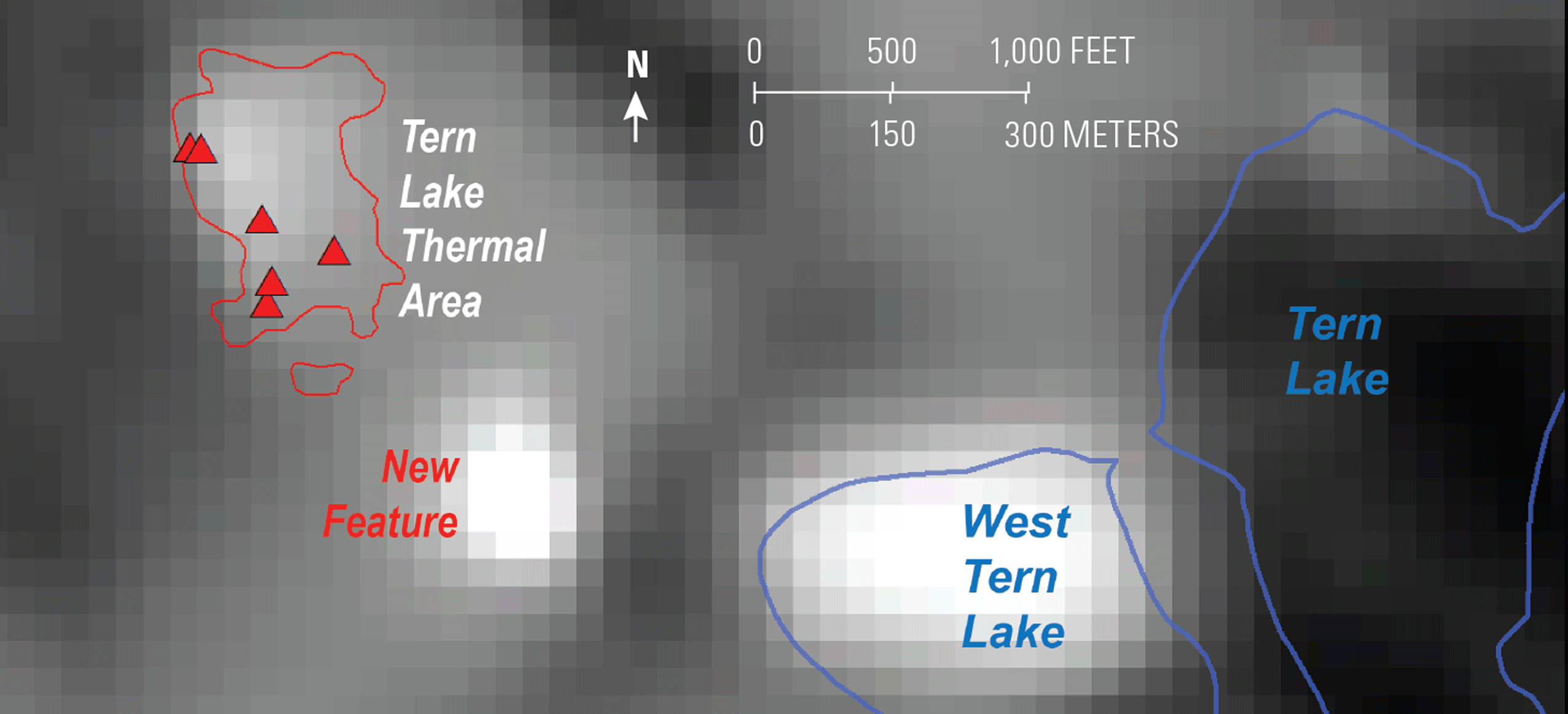
This Landsat 8 image from April 20, 2017, shows the new thermal area (white pixels indicate warmth) between the Tern Lake Thermal Area and West Tern Lake. Red triangles indicate individual mapped thermal features. Image credit: U.S. Geological Survey.
Mapping the Severity of Fires
More than one-third of Yellowstone National Park—nearly 800,000 acres—burned in 1988 during a series of 51 wildfires. Most of these fires were caused by lightning and exacerbated by fire fuel accumulations and unusually dry conditions that July. The fires burned at different intensities in different areas, producing a mosaic of burned and unburned areas (NPS, 2021). The Landsat-based program Monitoring Trends in Burn Severity (MTBS) illustrates mosaics like this by mapping the severity and extent of large fires across the United States from 1984 to the present—nearly 29,000 fires so far. MTBS information helps with fire management strategies, land management, and research about fires and fire recovery (MTBS, 2022).
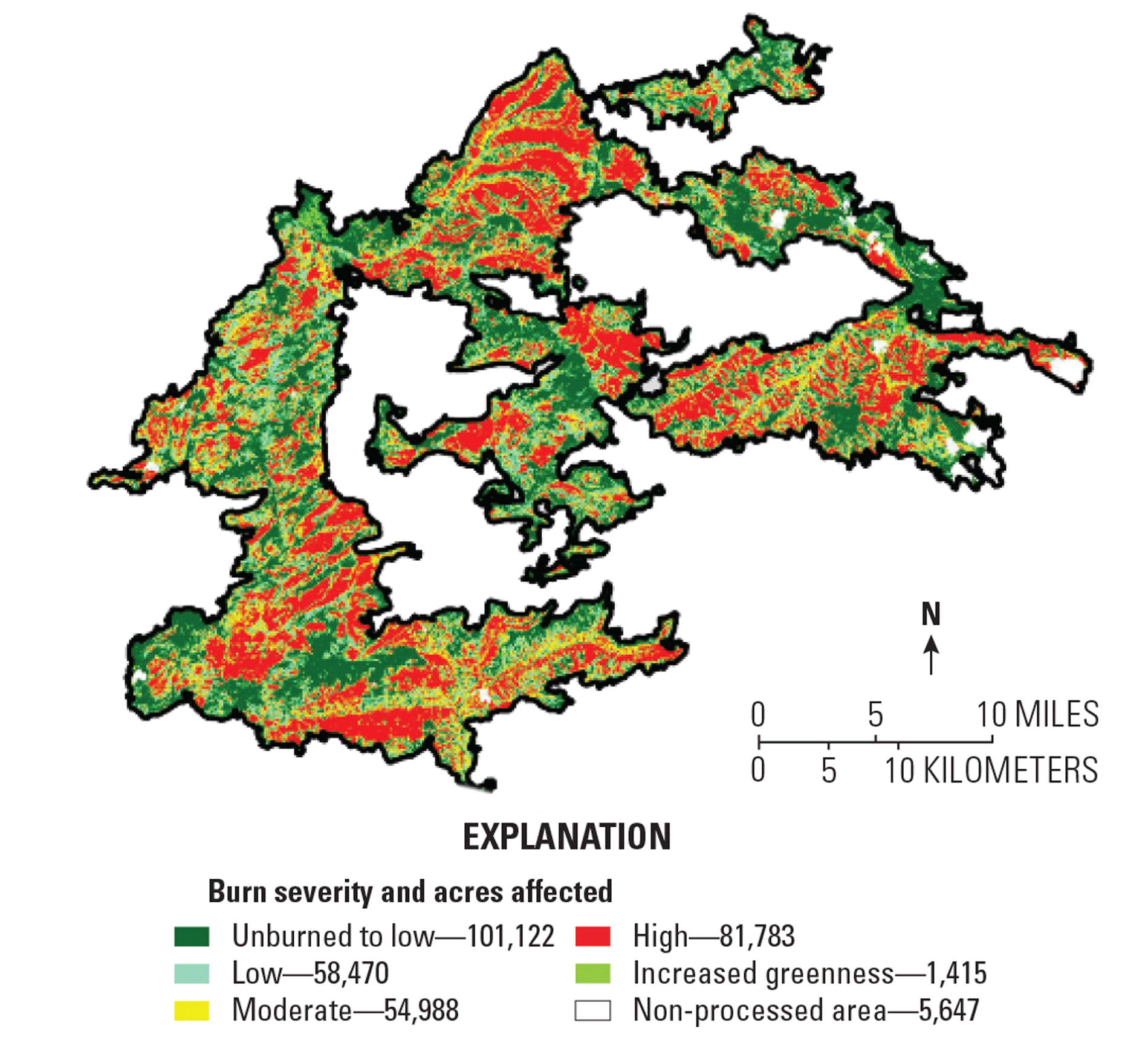
The Monitoring Trends in Burn Severity (MTBS) program mapped the 1988 Clover Mist Fire, which burned thousands of acres in and around Yellowstone National Park. Map credit: U.S. Geological Survey and U.S. Department of Agriculture Forest Service.
Tracking Change Over Time
Land cover often changes over time, and Landsat serves as the basis of many tools and studies that monitor these changes to the benefit of land managers and modelers. In one example, a study of a southwestern Wyoming sagebrush ecosystem conducted by scientists at the USGS used 32 years of Landsat data to determine the amount and variance of shrubland changes, and the effect of temperature and precipitation on those changes. Information like this can help anticipate the effects of climate change (Shi and others, 2020).
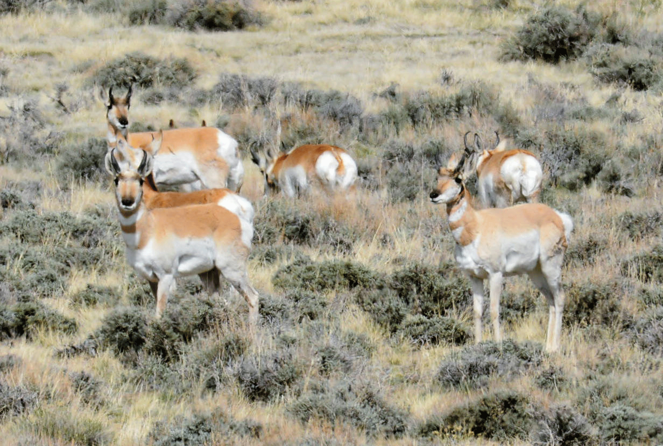
Pronghorn foraging in sagebrush habitat near Split Rock, Wyoming. Photograph credit: Jennifer Strickland, U.S. Fish and Wildlife Service.
National Land Imaging Program Benefits—Wyoming
The U.S. Geological Survey (USGS) National Land Imaging Program provides a wide range of satellite imagery and other remotely sensed and geospatial data to Government, commercial, academic, and public users. Those users can get worldwide access to Landsat satellite data through the National Land Imaging Program-funded USGS Earth Resources Observation and Science (EROS) Center.
Landsat—Critical Information Infrastructure for the Nation
Landsat is the most widely used land remote sensing data source within Federal civilian agencies. Local, State, Tribal, and Federal agencies use Landsat to monitor and forecast a wide range of land surface phenomena. Information from Landsat contributes to day-to-day decisions on land, water, and resource use that protect life and property; safeguard the environment; advance science, technology and education; support climate change resiliency; and grow the U.S. economy. Landsat’s imagery provides a landscape-level view of land surface, inland lake, and coastal processes, both natural and human-induced. Landsat enables us to better understand the scope, nature, and speed of change to the natural and built environment.
Businesses draw upon Landsat data to provide customer-specific applications to improve logistics, resource allocation, and investment decisions. Commercial space-imaging firms leverage Landsat data to refine product offerings and support new information services. A 2017 USGS study determined the total annual economic benefit of Landsat data in the United States to be $2.06 billion, far surpassing its development and operating costs (Straub and others, 2019).
Landsat 8 and Landsat 9 provide 8-day repeat coverage of the Earth’s land surfaces. The National Aeronautics and Space Administration (NASA) and the USGS are currently reviewing the findings from a joint Architecture Study Team, which will inform the design and implementation approach for Landsat Next, the follow-on mission to Landsat 9. Landsat 9 and its successors are planned to provide a sustainable, space-based system to extend the 50-year Landsat series of high-quality global land imaging measurements—the world’s longest time series of the Earth’s land surface.
The long-term availability of consistent and accurate Landsat data, combined with a no-cost data policy, allows users to analyze extensive geographic areas and better understand and manage long-term trends in land surface change. New cloud computing and data analytics technologies use Landsat data in a wide range of decision-support tools for Government and industry. Much like global positioning systems and weather data, Landsat data are used every day to help us better understand our dynamic planet.
References Cited
Monitoring Trends in Burn Severity [MTBS], 2022, Project overview: Monitoring Trends in Burn Severity web page, accessed March 4, 2022, at https://www.mtbs.gov/project-overview.
National Park Service [NPS], 2021, Yellowstone National Park—1988 fires: National Park Service web page, accessed March 3, 2022, at https://www.nps.gov/yell/learn/nature/1988-fires.htm.
Shi, H., Homer, C., Rigge, M., Postma, K., and Xian, G., 2020, Analyzing vegetation change in a sagebrush ecosystem using long-term field observations and Landsat imagery in Wyoming: Ecosphere, v. 11, no. 12, accessed March 4, 2022, at https://doi.org/10.1002/ecs2.3311.
Straub, C.L., Koontz, S.R., and Loomis, J.B., 2019, Economic valuation of Landsat imagery: U.S. Geological Survey Open-File Report 2019–1112, 13 p., accessed January 13, 2022, at https://doi.org/10.3133/ofr20191112.
Vaughan, R.G., Hungerford, J.D.G., and Keller, W., 2020, A newly emerging thermal area in Yellowstone: Frontiers of Earth Science, v. 8, accessed March 3, 2022. https://doi.org/10.3389/feart.2020.00204.
For additional information on Landsat, please contact:
Program Coordinator
USGS National Land Imaging Program
12201 Sunrise Valley Drive
Reston, VA 20192
703–648–5953
The Landsat series is a joint effort of USGS and NASA. NASA develops and launches the spacecraft; USGS manages satellite operations, ground reception, data archiving, product generation, and data distribution. Funding for the National Land Imaging Program’s Landsat operations and data management is provided through the USGS.
Suggested Citation
U.S. Geological Survey, 2022, Wyoming and Landsat: U.S. Geological Survey Fact Sheet 2022–3027, 2 p., https://doi.org/10.3133/fs20223027.
ISSN: 2327-6932 (online)
ISSN: 2327-6916 (print)
Study Area
| Publication type | Report |
|---|---|
| Publication Subtype | USGS Numbered Series |
| Title | Wyoming and Landsat |
| Series title | Fact Sheet |
| Series number | 2022-3027 |
| DOI | 10.3133/fs20223027 |
| Year Published | 2022 |
| Language | English |
| Publisher | U.S. Geological Survey |
| Publisher location | Reston, VA |
| Contributing office(s) | Earth Resources Observation and Science (EROS) Center |
| Description | 2 p. |
| Country | United States |
| State | Wyoming |
| Online Only (Y/N) | N |
| Google Analytic Metrics | Metrics page |