

New Jersey and Landsat
Links
- Document: Report (3.67 MB pdf) , HTML , XML
- Download citation as: RIS | Dublin Core
Abstract
New Jersey ranks among the smallest of States but packs a lot within its borders. Of course, that includes the more than 9 million people who make it the most densely populated State, but it also includes diverse landscapes. Ranging from Atlantic Ocean barrier islands and beaches to the Appalachian Mountains, and Pine Barrens forests to swampland, the “Garden State” retains remnants of an agricultural past with produce, horse, and dairy farms and plant nurseries.
The third State to join the Union has had a strong geographic presence in U.S. history. More than 200 American Revolution battles and skirmishes were fought in New Jersey—more than in any other State (National Park Service, 2017). Manufacturing, tourism, and fishing have each had a significant effect on New Jersey’s industrial history. Today, many residents commute from this strategic location to work in New York City, just across the Hudson River to the northeast, or in Philadelphia, just across the Delaware River to the west.
A dense population and climate change can increase risks for residents and the natural resources around them. Landsat helps officials monitor and plan for resilient cities and landscapes. Here are a few specific ways Landsat benefits New Jersey.
Identifying City Hotspots
Urban heat islands are areas within cities that have more impervious surfaces, such as buildings and pavement, and fewer natural features. These characteristics contribute to urban temperatures that exceed those of surrounding areas and can contribute to heat-related illnesses and deaths. Sustainable Jersey (https://www.sustainablejersey.com/) is a nonprofit organization that works in collaboration with state agencies, nonprofit organizations, foundations, academia, and industry to research best practices for what communities can and should do to contribute to a sustainable future. The best practices are codified in a certification program that recognizes municipalities and schools that have documented implementation. Sustainable Jersey used Landsat 8 thermal imagery to create a heat island map of New Jersey, which includes land surface temperatures and a tree canopy layer from the Landsat-based National Land Cover Database, to help municipalities identify and mitigate their hot spots (Sustainable Jersey, 2022).
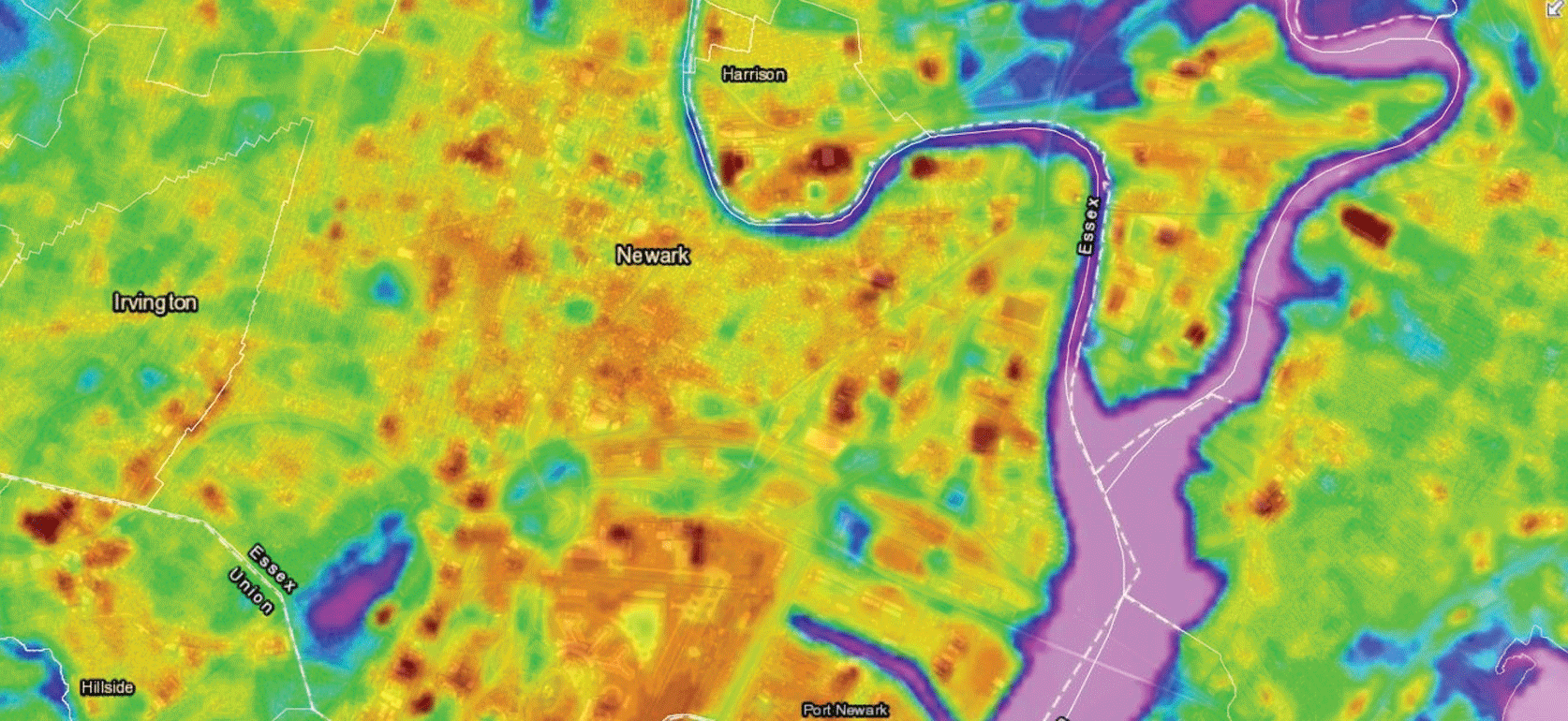
The New Jersey heat island map of land surface temperatures from Landsat data taken on June 25, 2016, and focusing on the Newark area. Purple-blue colors show cooler spots; orange-red colors show warmer spots. Image credit: Sustainable Jersey (Sustainable Jersey, 2020), used with permission.
Reducing Wildfire Risks
The Pinelands Commission is a State agency that oversees the Pinelands National Reserve, which covers 22 percent of New Jersey. Rising populations and activity in wildland urban interfaces—zones where developed and undeveloped lands meet—have increased the risk of damaging wildfires. A NASA DEVELOP Program project partnered with the Pinelands Commission to develop a fire risk assessment tool and map, with Landsat 8 among the data sources used to analyze the risk of wildfires in the wildland urban interfaces to identify areas most suitable for future development (NASA, 2018). Landsat also provides the foundational data for the Federal interagency Monitoring Trends in Burn Severity (MTBS) program. MTBS maps the location, extent, and burn severity of all large U.S. fires to help guide fire management monitoring, risk assessments, and resource decisions (MTBS, 2021).
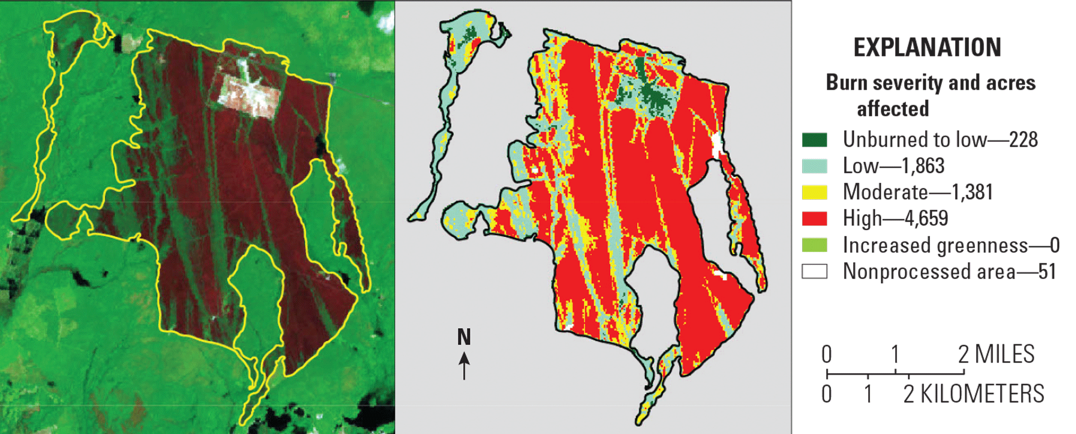
The extent and severity of the Spring Hill fire, which started March 30, 2019, in the Pine Barrens, is shown in this Monitoring Trends in Burn Severity map. Image credit: U.S. Geological Survey and Forest Service.
Analyzing Coastal Wetlands
Hurricane Sandy, which blasted ashore near Atlantic City on October 29, 2012, ranks as New Jersey’s most destructive natural disaster. It damaged 346,000 homes and eroded the entire coastline (Bilinski and others, 2015). The State Department of Environmental Protection determined that areas with coastal wetlands were more protected, experiencing less severe physical and economic damage (Bilinski and others, 2015). University of Maryland researchers used Landsat data from 2000 to 2015 to analyze the effects of Hurricane Sandy on New Jersey’s valuable coastal marshes. Resulting maps characterized variations in marsh vegetation and could be used to help identify areas at risk from future sea level rise and storm damage (Rangoonwala and others, 2017).
National Land Imaging Program Benefits—New Jersey
The U.S. Geological Survey (USGS) National Land Imaging Program provides a wide range of satellite imagery and other remotely sensed and geospatial data to Government, commercial, academic, and public users. Those users can get worldwide access to Landsat satellite data through the National Land Imaging Program-funded USGS Earth Resources Observation and Science (EROS) Center.
Landsat—Critical Information Infrastructure for the Nation
Landsat is the most widely used land remote sensing data source within Federal civilian agencies. Local, State, Tribal, and Federal agencies use Landsat to monitor and forecast a wide range of land surface phenomena. Information from Landsat contributes to day-to-day decisions on land, water, and resource use that protect life and property; safeguard the environment; advance science, technology, and education; support climate change resiliency; and grow the U.S. economy. Landsat’s imagery provides a landscape-level view of land surface, inland lake, and coastal processes, both natural and human-induced. Landsat enables us to better understand the scope, nature, and speed of change to the natural and built environment.
Businesses draw upon Landsat data to provide customer-specific applications to improve logistics, resource allocation, and investment decisions. Commercial space imaging firms leverage Landsat data to refine product offerings and support new information services. A 2017 USGS study determined the total annual economic benefit of Landsat data in the United States. to be $2.06 billion, far surpassing its development and operating costs (Straub and others, 2019).
Landsat 8 and Landsat 9 provide 8-day repeat coverage of the Earth’s land surfaces. The National Aeronautics and Space Administration (NASA) and the USGS are currently reviewing the findings from a joint Architecture Study Team, which will inform the design and implementation approach for Landsat Next, the follow-on mission to Landsat 9. Landsat 9 and its successors are planned to provide a sustainable, space-based system to extend the 50-year Landsat series of high-quality global land imaging measurements—the world’s longest time series of the Earth’s land surface.
The long-term availability of consistent and accurate Landsat data, combined with a no-cost data policy, allows users to analyze extensive geographic areas and better understand and manage long-term trends in land surface change. New cloud computing and data analytics technologies use Landsat data in a wide range of decision-support tools for Government and industry. Much like global positioning systems and weather data, Landsat data are used every day to help us better understand our dynamic planet.
References Cited
Bilinski, J., Buchanan, G., Frizzera, D., Hazen, R., Lippincott, L., Procopio, N., Ruppel, B., and Tucker, T., 2015, Damage assessment report on the effects of Hurricane Sandy on the State of New Jersey’s natural resources: Trenton, N.J., New Jersey Department of Environmental Protection, 64 p., accessed April 11, 2022, at https://www.nj.gov/dep/dsr/hurricane-sandy-assessment.pdf.
Monitoring Trends in Burn Severity [MTBS], 2021, Frequently asked questions—project overview: MTBS web page, accessed April 8, 2022, at https://mtbs.gov/index.php/faqs.
National Aeronautics and Space Administration [NASA], 2018, Identifying optimal regions within New Jersey’s Pine Barrens forest for urban development based on wildfire risk and the wildland-urban interface theory: NASA web page, accessed April 8, 2022, at https://develop.larc.nasa.gov/2018/spring/NewJerseyUrban.html.
National Park Service, 2017, Crossroads of the American Revolution National Heritage Area: National Park Service web page, accessed July 5, 2022, at https://www.nps.gov/places/crossroads-national-heritage-area.htm.
Rangoonwala, A., Riter, J.C.A., Kearney, M.S., and Ramsey, E.W., III, 2017, Analysis of the effect of Hurricane Sandy on New Jersey Atlantic coastal marshes based on Landsat Thematic Mapper and Operational Land Imager data—2000–2015: U.S. Geological Survey data release, accessed April 11, 2022, at https://doi.org/10.5066/F7D50K4W.
Straub, C.L., Koontz, S.R., and Loomis, J.B., 2019, Economic valuation of Landsat imagery: U.S. Geological Survey Open-File Report 2019–1112, 13 p., accessed April 8, 2022, at https://doi.org/10.3133/ofr20191112.
Sustainable Jersey, 2020, New Jersey heat island map: Sustainable Jersey digital data, accessed April 8, 2022, at https://www.arcgis.com/home/webmap/viewer.html?webmap=cb57fa89169d49e2bfd35cd2b4721225&extent=-74.8549,40.4428,-73.8407,40.9509.
Sustainable Jersey, 2022, Actions—Emergency management & resiliency—Heat island assessment: Sustainable Jersey web page, accessed April 8, 2022, at https://www.sustainablejersey.com/actions/#open/action/570.
For additional information on Landsat, please contact:
Program Coordinator
USGS National Land Imaging Program
12201 Sunrise Valley Drive
Reston, VA 20192
703–648–4567
The Landsat series is a joint effort of USGS and NASA. NASA develops and launches the spacecraft; USGS manages satellite operations, ground reception, data archiving, product generation, and data distribution. Funding for the National Land Imaging Program’s Landsat operations and data management is provided through the USGS.
Suggested Citation
U.S. Geological Survey, 2022, New Jersey and Landsat: U.S. Geological Survey Fact Sheet 2022–3054, 2 p., https://doi.org/10.3133/fs20223054.
ISSN: 2327-6932 (online)
ISSN: 2327-6916 (print)
Study Area
| Publication type | Report |
|---|---|
| Publication Subtype | USGS Numbered Series |
| Title | New Jersey and Landsat |
| Series title | Fact Sheet |
| Series number | 2022-3054 |
| DOI | 10.3133/fs20223054 |
| Year Published | 2022 |
| Language | English |
| Publisher | U.S. Geological Survey |
| Publisher location | Reston, VA |
| Contributing office(s) | Earth Resources Observation and Science (EROS) Center |
| Description | 2 p. |
| Country | United States |
| State | New Jersey |
| Online Only (Y/N) | N |
| Google Analytic Metrics | Metrics page |