

Nebraska and Landsat
Links
- Document: Report (2.80 MB pdf) , HTML , XML
- Download citation as: RIS | Dublin Core
Abstract
The rolling plains of Nebraska occupy a storied place in the American psyche. For those living outside the Midwest, the Cornhusker State may be seen as a symbol of the Nation’s heartland, cropped border to border, with country churches and barely standing barns to be found around every turn of its gravel roads.
Although the pioneer history and agricultural heritage of the 37th State lend credence to this idyllic view, Nebraska’s varied landscapes and modern economy make the reality of life in the State more complex than its rural image would suggest.
Agriculture remains Nebraska’s top industry, but manufacturing now represents 12 percent of the State’s gross domestic product. The financial services and insurance industries account for 8 percent of the gross domestic product in Nebraska, which is the headquarters of Berkshire Hathaway and Mutual of Omaha, the latter of which is named after Nebraska’s largest city, which grew nearly 12 percent between 2010 and 2020 (City of Omaha, 2021). Cropland is indeed a prominent feature in Nebraska, but the State also is home to 8 State parks, 5 national parks, 2 national forests, and 3 national grasslands. The grasses and dunes of the Nebraska Sand Hills that stretch across the north-central quarter of the State are a National Natural Landmark.
Data from the Landsat satellite program contribute to the study and management of Nebraska’s land in myriad ways, from monitoring crop productivity and aiding in rangeland management to tracking damage from floods, droughts, or hurricanes. Land cover maps produced using data pulled from the 50-year Landsat archive can offer important insights into urban growth, land use trends, and land change patterns. Here are a few examples of how Landsat has been used in Nebraska.
Mapping Irrigation, Informing Decisions
Irrigation is an important facet of Nebraska’s agricultural economy. Nebraska leads the Nation in irrigated agriculture acres with more than 9.3 million acres in 2020 (Nebraska Department of Environment and Energy, 2020). Most of the water comes from the Ogallala aquifer, a massive but shrinking reservoir that runs across 174,000 miles of the Great Plains from Texas to South Dakota. The aquifer’s largest water stores are in Nebraska. Landsat satellite data offer valuable insight into this resource. The Nebraska Department of Natural Resources has used Landsat’s decades-long archive of repeat Earth observations to map irrigated acres in the State to effectively manage water resources (Pun and others, 2017). Landsat’s archive also has fueled work that offers insight into long-term trends in irrigated acres in wet and drought years (Deines and others, 2017).
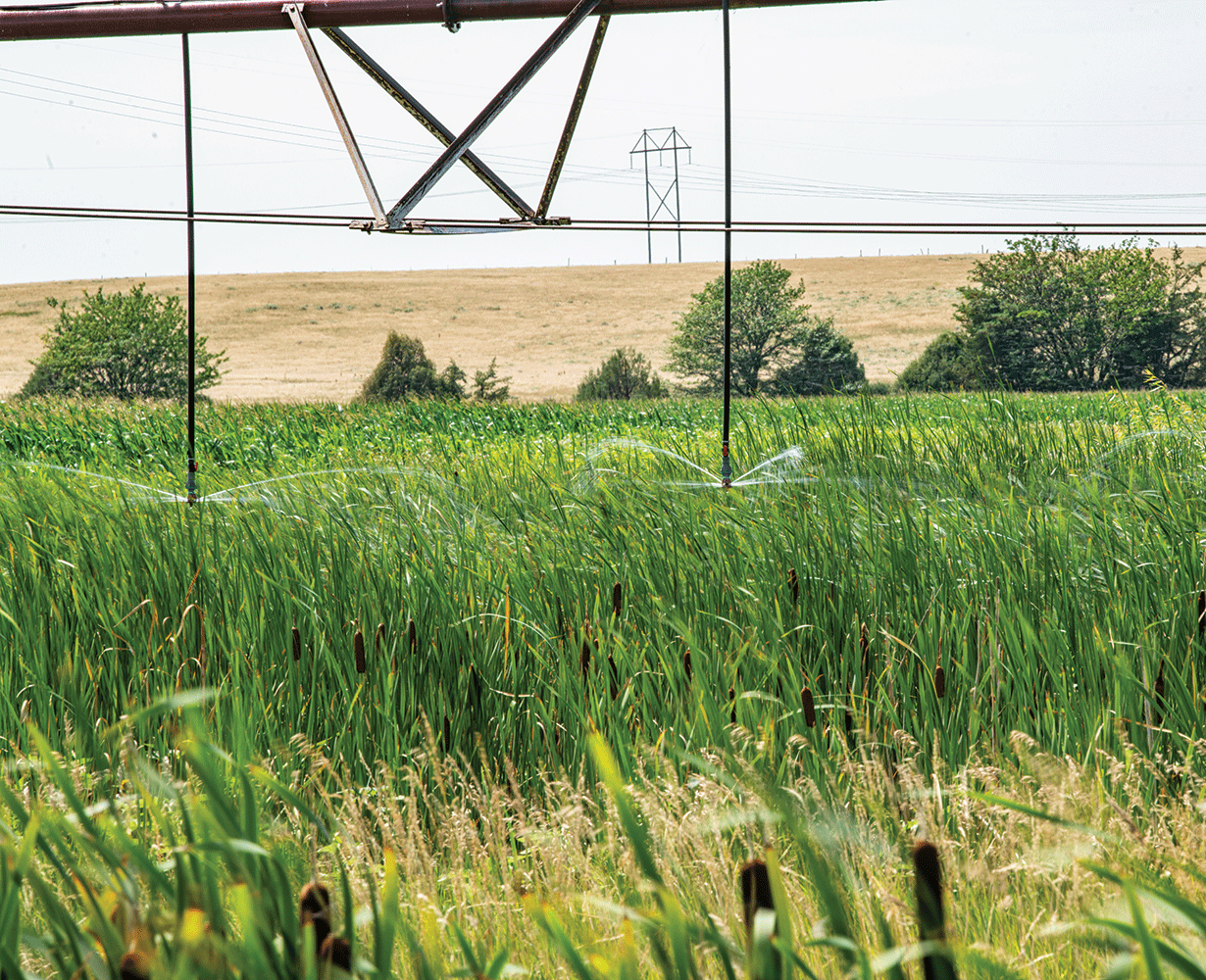
Field of cattail with pivot irrigation and a microsprinkler in northeastern Nebraska, taken on July 23, 2021. Photograph credit: Lance Cheung, U.S. Department of Agriculture.
Tracking Grassland, Cropland Productivity
In addition to being a leading producer of commodity crops like corn and soybeans, Nebraska is in the top five cattle production States in the United States. The health of the $12.5 billion Nebraska cattle industry is linked to the health of Nebraska’s rangelands. Researchers have used Landsat data to map biomass productivity across the Greater Platte River Basins at a 30-meter resolution, meaning each mapped pixel is about one-quarter acre in size (Gu and Wylie, 2015). The detailed maps are useful in ecosystem assessments and rangeland management decision-making at the landscape scale. Landsat’s ability to look beyond the visible light spectrum by peering into the infrared and thermal bands of the electromagnetic spectrum makes it a valuable tool for tracking the health and productivity of cropland (Wang and others, 2020).
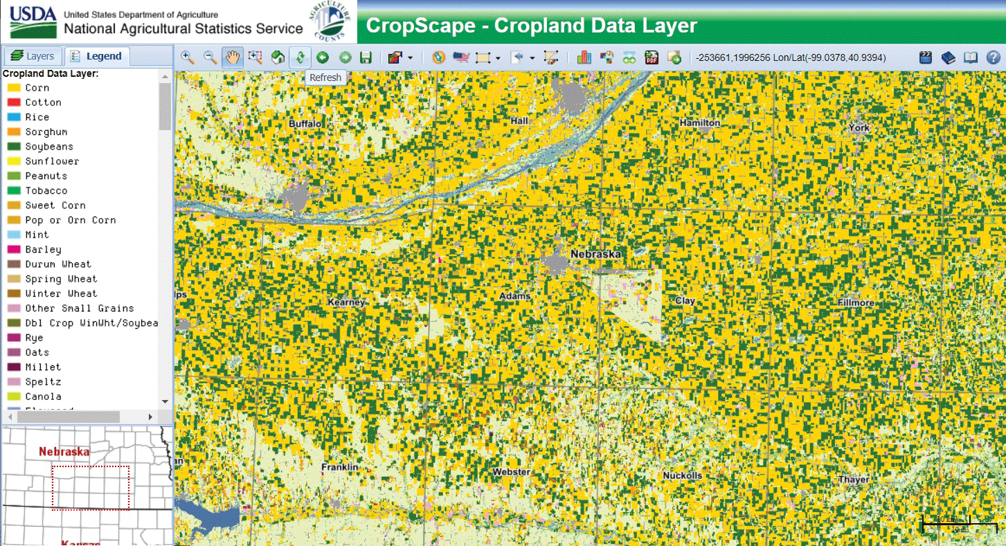
The U.S. Department of Agriculture leans on U.S. Geological Survey Landsat data and Landsat-based land cover products to create its Cropland Data Layer, which maps crop types across the United States. Dominant crops in Nebraska include corn, soybeans, spring wheat, and winter wheat. Image credit: U.S. Department of Agriculture.
Urban Growth and Land Use Change
The greater Omaha metropolitan area still has fewer than 1 million people (City of Omaha, 2021), but steady growth and suburban sprawl have led to the emergence of miles of new impervious surfaces, such as parking lots and roads. Urban growth and impervious surface coverage have implications for drainage and runoff planning, as well as for temperatures in the city, where impervious surfaces hold heat and make urban areas warmer than their rural counterparts. Thermal instruments on Landsat satellites allow researchers to track temperatures and assess hot spots created by the urban heat island effect (Imhoff and others, 2010). Data from the satellites’ repeat observations enable the creation of mapping products like the National Land Cover Database, which characterizes each 30-meter plot of land in the United States as a land cover class and tracks the percentage of cover of impervious surfaces in developed areas.
National Land Imaging Program Benefits—Nebraska
The U.S. Geological Survey (USGS) National Land Imaging Program provides a wide range of satellite imagery and other remotely sensed and geospatial data to Government, commercial, academic, and public users. Those users can get worldwide access to Landsat satellite data through the National Land Imaging Program-funded USGS Earth Resources Observation and Science (EROS) Center.
Landsat—Critical Information Infrastructure for the Nation
Landsat is the most widely used land remote sensing data source within Federal civilian agencies. Local, State, Tribal, and Federal agencies use Landsat to monitor and forecast a wide range of land surface phenomena. Information from Landsat contributes to day-to-day decisions on land, water, and resource use that protect life and property; safeguard the environment; advance science, technology, and education; support climate change resiliency; and grow the U.S. economy. Landsat’s imagery provides a landscape-level view of land surface, inland lake, and coastal processes, both natural and human-induced. Landsat enables us to better understand the scope, nature, and speed of change to the natural and built environment.
Businesses draw upon Landsat data to provide customer-specific applications to improve logistics, resource allocation, and investment decisions. Commercial space imaging firms leverage Landsat data to refine product offerings and support new information services. A 2017 USGS study determined the total annual economic benefit of Landsat data in the United States. to be $2.06 billion, far surpassing its development and operating costs (Straub and others, 2019).
Landsat 8 and Landsat 9 provide 8-day repeat coverage of the Earth’s land surfaces. The National Aeronautics and Space Administration (NASA) and the USGS are currently reviewing the findings from a joint Architecture Study Team, which will inform the design and implementation approach for Landsat Next, the follow-on mission to Landsat 9. Landsat 9 and its successors are planned to provide a sustainable, space-based system to extend the 50-year Landsat series of high-quality global land imaging measurements—the world’s longest time series of the Earth’s land surface.
The long-term availability of consistent and accurate Landsat data, combined with a no-cost data policy, allows users to analyze extensive geographic areas and better understand and manage long-term trends in land surface change. New cloud computing and data analytics technologies use Landsat data in a wide range of decision-support tools for Government and industry. Much like global positioning systems and weather data, Landsat data are used every day to help us better understand our dynamic planet.
References Cited
City of Omaha, 2021, Metro Omaha population nears 1,000,000: City of Omaha, August 12, 2021, accessed February 18, 2022, at https://www.cityofomaha.org/latest-news/804-metro-omaha-population-nears-1-000-000.
Deines, J.M., Kendall, A.D., and Hyndman, D.W., 2017, Annual irrigation dynamics in the U.S. northern high plains derived from Landsat satellite data: Geophysical Research Letters, v. 44, no. 18, p. 9350–9360. [Also available at https://doi.org/10.1002/2017GL074071.]
Gu, Y., and Wylie, B.K., 2015, Developing a 30-m grassland productivity estimation map for central Nebraska using 250-m MODIS and 30-m Landsat-8 observations: Remote Sensing of Environment, v. 171, p. 291–298. [Also available at https://doi.org/10.1016/j.rse.2015.10.018.]
Imhoff, M.L., Zhang, P., Wolfe, R.E., and Bounoua, L., 2010, Remote sensing of the urban heat island effect across biomes in the continental USA: Remote Sensing of Environment, v. 114, no. 3, p. 504–513. [Also available at https://doi.org/10.1016/j.rse.2009.10.008.]
Nebraska Department of Environment and Energy, 2020, Irrigated acres in Nebraska, 1964–2020: Nebraska Department of Environment and Energy web page, accessed February 18, 2022, at https://neo.ne.gov/programs/stats/inf/73b.html.
Pun, M., Mutiibwa, D., and Li, R., 2017, Land use classification—A surface energy balance and vegetation index application to map and monitor irrigated lands: Remote Sensing (Basel), v. 9, no. 12, art. 1256, 19 p., accessed July 18, 2022, at https://doi.org/10.3390/rs9121256.
Straub, C.L., Koontz, S.R., and Loomis, J.B., 2019, Economic valuation of Landsat imagery: U.S. Geological Survey Open-File Report 2019–1112, 13 p., accessed April 8, 2022, at https://doi.org/10.3133/ofr20191112.
Wang, S., Di Tommaso, S., Deines, J.M., and Lobell, D.B., 2020, Mapping twenty years of corn and soybean across the US Midwest using the Landsat archive: Scientific Data, v. 7, art. 307, 14 p., accessed July 18, 2022, at https://doi.org/10.1038/s41597-020-00646-4.
For additional information on Landsat, please contact:
Program Coordinator
USGS National Land Imaging Program
12201 Sunrise Valley Drive
Reston, VA 20192
703–648–4567
The Landsat series is a joint effort of USGS and NASA. NASA develops and launches the spacecraft; USGS manages satellite operations, ground reception, data archiving, product generation, and data distribution. Funding for the National Land Imaging Program’s Landsat operations and data management is provided through the USGS.
Suggested Citation
U.S. Geological Survey, 2022, Nebraska and Landsat: U.S. Geological Survey Fact Sheet 2022–3056, 2 p., https://doi.org/10.3133/fs20223056.
ISSN: 2327-6932 (online)
ISSN: 2327-6916 (print)
Study Area
| Publication type | Report |
|---|---|
| Publication Subtype | USGS Numbered Series |
| Title | Nebraska and Landsat |
| Series title | Fact Sheet |
| Series number | 2022-3056 |
| DOI | 10.3133/fs20223056 |
| Year Published | 2022 |
| Language | English |
| Publisher | U.S. Geological Survey |
| Publisher location | Reston, VA |
| Contributing office(s) | Earth Resources Observation and Science (EROS) Center |
| Description | 2 p. |
| Country | United States |
| State | Nebraska |
| Online Only (Y/N) | N |
| Google Analytic Metrics | Metrics page |