

Alabama and Landsat
Links
- Document: Report (6.27 MB pdf) , HTML , XML
- Download citation as: RIS | Dublin Core
Abstract
Alabama’s warm climate and rich soil bolster its agriculture and timber industries, but they also offer ideal conditions for natural playgrounds, enjoyed by humans and the wildlife that call the open green spaces home. Alabama has 21 State parks and 11 national parks, monuments, and trails across its diverse geography.
Cotton is no longer king in the Cotton State, but it remains a part of the fabric of its multibillion-dollar agriculture sector. The State also produces poultry, cattle, calves, corn, lumber, soybeans, and catfish.
The State is home to Dauphin Island, the first land mass seen by migratory birds and pollinators upon their return from South America. Dauphin Island acts as a landing zone for hundreds of species, including sandpipers, plovers, and herons, and protects Alabama’s coastline. Since 1961, Dauphin Island has been the home of the Audubon Bird Sanctuary.
The varied landscapes of the Cotton State face challenges from climate change, land change, and extreme weather. Satellite imagery from the USGS Landsat Program can offer insight and understanding in these and other areas. Here are some ways Landsat benefits Alabama.
Tracking Crop Health, Productivity
Landsat imagery is a key data source for the U.S. Department of Agriculture’s Cropland Data Layer (CDL), a mapping tool that tracks the crops grown annually across the United States. The CDL is useful for tracking trends in crop rotation in agricultural States like Alabama, and it supports research that stretches beyond year-by-year acreage tallies and offers valuable insight for improved agricultural operations. For example, researchers used the CDL to map peach orchards in a study that analyzed the risk of warming winters to peach production in Alabama and across the southeastern United States (Parker and Abatzoglou, 2019).
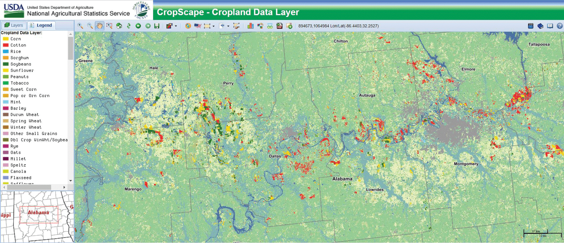
The U.S. Department of Agriculture’s Cropland Data Layer, shown here for Montgomery, Alabama, and west, reveals land cover. The landscape includes forest (medium green), grass/pasture (yellow green), cotton (red), corn (gold), and soybeans (dark green). Wetland areas are medium blue, rivers and lakes are dark blue, and developed areas are gray. Image credit: U.S. Department of Agriculture.
Tracking Severe Weather Damage
Landsat is critical in space-based disaster monitoring. Its repeat coverage feeds into mapping products like LANDFIRE, a tool used by fire scientists for understanding fuel sources and related land cover information nationwide. Landsat also is the data source for the Monitoring Trends in Burn Severity information service, which maps all large U.S. fires from 1984 to the present (2022).
Fires are a risk for Alabama, but the State also is prone to tornadoes, and its coastlines and inland areas are threatened by Gulf Coast hurricanes. Landsat is a trusted science-quality source of imagery for wide-scale damage surveys after such incidents and helps researchers to understand the short- and long-term effects of severe weather on landscapes and the built environment. In April 2011, 62 confirmed tornadoes struck Alabama in a single day. A 2017 study used Landsat to track forest and cropland recovery in the 5 years after the swarm (Kingfield and de Beurs, 2017).
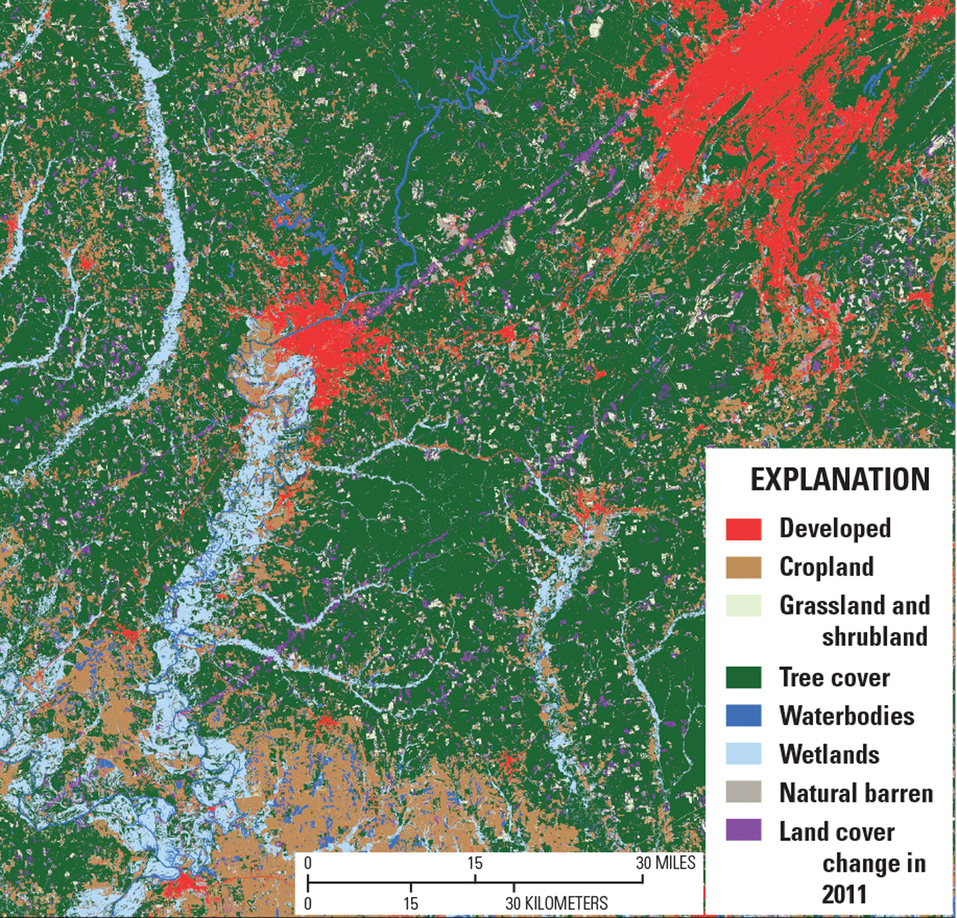
Image showing the effect of tornadoes that struck the Tuscaloosa (left, in red) and Birmingham (upper right), Alabama, areas on April 27, 2011, as captured by the U.S. Geological Survey Land Change Monitoring, Assessment, and Projection land cover change product, built using Landsat data. The long purple streaks mark changes to the landscape, which coincide with the track of the tornadoes. Image credit: U.S. Geological Survey.
Ecosystem Management
Alabama has a wealth of natural wonders, from the native Pinus taeda L. (loblolly pines) that have become an important commodity to the barrier islands that draw migratory birds and tourists. Landsat imagery can offer valuable insight on changes to these features through repeat observation. Researchers determined that Landsat observations can track loblolly health at the landscape scale through growing seasons (Blinn and others, 2019), which is useful to forest managers for targeting interventions to improve forest health. Landsat also factored into a management plan for Dauphin Island produced by the USGS and other Federal partners with consideration of State and local objectives. The plan serves as an outline for sound management of the island, which offers protection to Alabama’s coastal resources (Steyer and others, 2020).
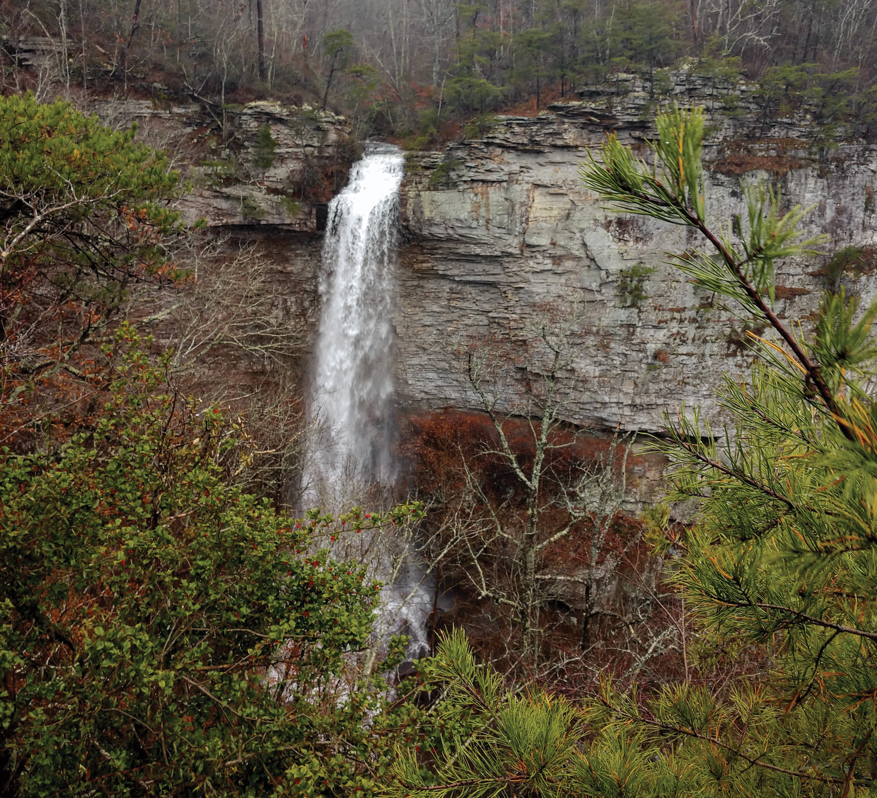
At 133 feet high, Grace’s High Falls is the tallest waterfall in Alabama. Best seen in winter and spring, this seasonal waterfall depends on rainfall to put on a show. Photograph credit: Matt Switzer, National Park Service.
National Land Imaging Program Benefits—Alabama
The U.S. Geological Survey (USGS) National Land Imaging Program provides a wide range of satellite imagery and other remotely sensed and geospatial data to Government, commercial, academic, and public users. Those users can get worldwide access to Landsat satellite data through the National Land Imaging Program-funded USGS Earth Resources Observation and Science (EROS) Center.
Landsat—Critical Information Infrastructure for the Nation
Landsat is the most widely used land remote sensing data source within Federal civilian agencies. Local, State, Tribal, and Federal agencies use Landsat to monitor and forecast a wide range of land surface phenomena. Information from Landsat contributes to day-to-day decisions on land, water, and resource use that protect life and property; safeguard the environment; advance science, technology, and education; support climate change resiliency; and grow the U.S. economy. Landsat’s imagery provides a landscape-level view of land surface, inland lake, and coastal processes, both natural and human-induced. Landsat enables us to better understand the scope, nature, and speed of change to the natural and built environment.
Businesses draw upon Landsat data to provide customer-specific applications to improve logistics, resource allocation, and investment decisions. Commercial space imaging firms leverage Landsat data to refine product offerings and support new information services. A 2017 USGS study determined the total annual economic benefit of Landsat data in the United States. to be $2.06 billion, far surpassing its development and operating costs (Straub and others, 2019).
Landsat 8 and Landsat 9 provide 8-day repeat coverage of the Earth’s land surfaces. The National Aeronautics and Space Administration (NASA) and the USGS are currently reviewing the findings from a joint Architecture Study Team, which will inform the design and implementation approach for Landsat Next, the follow-on mission to Landsat 9. Landsat 9 and its successors are planned to provide a sustainable, space-based system to extend the 50-year Landsat series of high-quality global land imaging measurements—the world’s longest time series of the Earth’s land surface.
The long-term availability of consistent and accurate Landsat data, combined with a no-cost data policy, allows users to analyze extensive geographic areas and better understand and manage long-term trends in land surface change. New cloud computing and data analytics technologies use Landsat data in a wide range of decision-support tools for Government and industry. Much like global positioning systems and weather data, Landsat data are used every day to help us better understand our dynamic planet.
References Cited
Blinn, C.E., House, M.N., Wynne, R.H., Thomas, V.A., Fox, T.R., and Sumnall, M., 2019, Landsat 8 based leaf area index estimation in loblolly pine plantations: Forests, v. 10, no. 3, art. 222, 18 p., accessed July 19, 2022, at https://doi.org/10.3390/f10030222.
Kingfield, D.M., and de Beurs, K.M., 2017, Landsat identification of tornado damage by land cover and an evaluation of damage recovery in forests: Journal of Applied Meteorology and Climatology, v. 56, no. 4, p. 965–987. [Also available at https://doi.org/10.1175/JAMC-D-16-0228.1.]
Parker, L.E., and Abatzoglou, J.T., 2019, Warming winters reduce chill accumulation for peach production in the southeastern United States: Climate (Basel), v. 7, no. 8, art. 94, 13 p., accessed July 19, 2022, at https://doi.org/10.3390/cli7080094.
Steyer, G.D., Meyers, M.B., and Spear, K.A., 2020, Alabama barrier island restoration assessment—Monitoring and adaptive management plan: U.S. Geological Survey, U.S. Army Corps of Engineers, and National Oceanic and Atmospheric Administration, 26 p., accessed May 20, 2022, at https://gom.usgs.gov/DauphinIsland/data/AppL_MAMPlan_2020April20_Final.pdf.
Straub, C.L., Koontz, S.R., and Loomis, J.B., 2019, Economic valuation of Landsat imagery: U.S. Geological Survey Open-File Report 2019–1112, 13 p., accessed April 8, 2022, at https://doi.org/10.3133/ofr20191112.
For additional information on Landsat, please contact:
Program Coordinator
USGS National Land Imaging Program
12201 Sunrise Valley Drive
Reston, VA 20192
703–648–4567
The Landsat series is a joint effort of USGS and NASA. NASA develops and launches the spacecraft; USGS manages satellite operations, ground reception, data archiving, product generation, and data distribution. Funding for the National Land Imaging Program’s Landsat operations and data management is provided through the USGS.
Suggested Citation
U.S. Geological Survey, 2022, Alabama and Landsat: U.S. Geological Survey Fact Sheet 2022–3060, 2 p., https://doi.org/10.3133/fs20223060.
ISSN: 2327-6932 (online)
ISSN: 2327-6916 (print)
Study Area
| Publication type | Report |
|---|---|
| Publication Subtype | USGS Numbered Series |
| Title | Alabama and Landsat |
| Series title | Fact Sheet |
| Series number | 2022-3060 |
| DOI | 10.3133/fs20223060 |
| Year Published | 2022 |
| Language | English |
| Publisher | U.S. Geological Survey |
| Publisher location | Reston, VA |
| Contributing office(s) | Earth Resources Observation and Science (EROS) Center |
| Description | 2 p. |
| Country | United States |
| State | Alabama |
| Online Only (Y/N) | N |
| Google Analytic Metrics | Metrics page |