

Mississippi and Landsat
Links
- Document: Report (3.56 MB pdf) , HTML , XML
- Download citation as: RIS | Dublin Core
Abstract
Mississippi holds a significant place in the cultural and economic history of the United States. For example, the Magnolia State was a hotbed for the Delta blues, an early 20th century musical genre with tremendous cultural effects in the United States and around the world. The “Delta” in Delta blues is the Mississippi River Delta, the largest delta in the United States. The Mississippi River is one of the longest in the Nation, having 1,800 navigable miles that serve as a natural transportation corridor that is foundational to America’s economic fortunes.
This important waterway forms Mississippi’s western border, and the fertile alluvial soils that fan out across its western third served to bolster its early economy and remain key drivers of its agriculture sector. These soils continue to support cotton, soybeans, corn, and agricultural products for which Mississippi is a national leader: rice and farmed catfish.
Such heavy reliance on the land necessitates a strong understanding of the health of—and threats to—the landscape. Spikes in extreme heat and associated wildfire dangers, the increasing frequency of powerful hurricanes on the Gulf Coast, and annual tornadoes all stand as challenges to the Magnolia State’s land resources.
The USGS Landsat program serves a critical role in mapping, monitoring, and understanding changes across Mississippi. Here are a few examples of how Landsat benefits the State.
Monitoring Forest Health
Landsat is useful for monitoring forest health. Researchers can use the program’s long record of repeat observations to track trends over time, as scientists did in 2013 to evaluate the effect of forest disturbances to carbon storage in the forests of Mississippi and Alabama (Chen and others, 2013). Long-term trends in forest disturbance and tree canopy extent also are captured by Landsat-based map layers produced by the interagency Landscape Fire and Resource Management Planning Tools program; the National Land Cover Database; and the USGS Land Change Monitoring, Assessment, and Projection initiative.
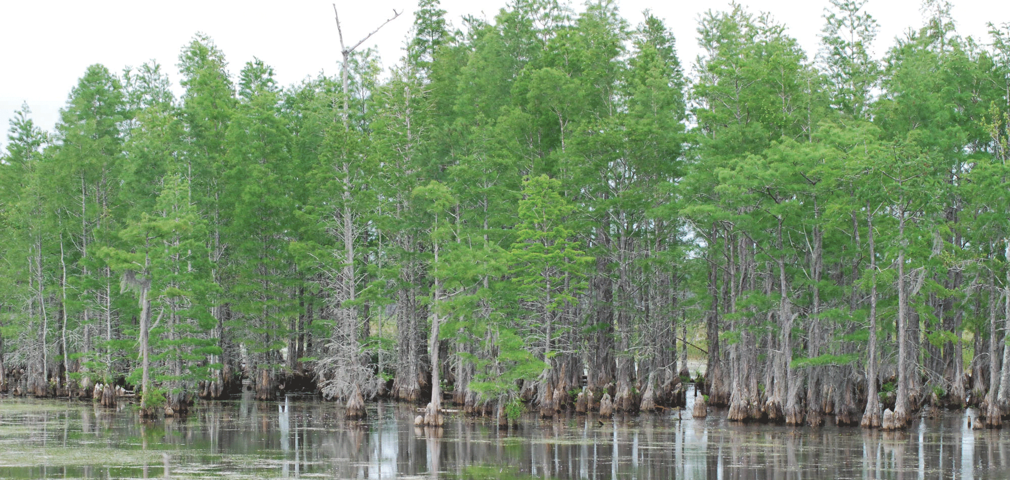
Vegetation communities in the Mississippi Sandhill Crane National Wildlife Refuge are a mosaic of pine savannas and pinelands interspersed with wooded swamps and drainages, along with a small tract of estuarine marsh. Photograph credit: U.S. Fish and Wildlife Service.
Cataloging Crop Health, Crop Types
Agriculture is one of Mississippi’s top industries, along with forestry. The 2017 U.S. Department of Agriculture Census of Agriculture put livestock and crop sales in the State at $6.2 billion, and poultry led the statewide commodities list (Dickson, 2021). With so much of Mississippi’s economy focused on agricultural production, Landsat’s value in the arena of wide-scale crop monitoring is particularly beneficial. Landsat data are a key input to the U.S. Department of Agriculture’s Cropland Data Layer, which tracks annual U.S. crop types at a 30-meter spatial resolution and offers an observation-based data source to supplement producer-reported planting. Landsat data are useful to agriculture in ways beyond crop cataloging, however. The ability of Landsat sensors to peer beyond visible light and into the infrared and near-infrared parts of the electromagnetic spectrum allow researchers to assess crop health by calculating field-scale Normalized Difference Vegetation Index and Enhanced Vegetation Index values, both of which serve as a proxy for plant greenness. Such information can serve as the basis for crop yield estimates across Mississippi, which can help guide decisions on fertilizer application, irrigation, and weed control (Wang and others, 2019).
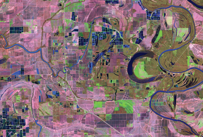
The blue rectangular shapes in this false-color Landsat 9 image from February 2022 show catfish aquaculture ponds near Belzoni, Mississippi. Landsat imagery is useful for landscape-scale tracking of land use and for monitoring crop health throughout the growing season. Image credit: U.S. Geological Survey.
Tracking Damage from Extreme Weather
Tornadoes represent a serious danger to life, property, cropland, and natural resources in Mississippi; however, extreme weather events also originate over water. The State’s Gulf Coast faces a steady stream of threats from hurricanes. Landsat imagery is a powerful tool for tracking wide-scale damage from tornadoes and hurricanes, such as coastal erosion and inland flooding. Emergency managers use Landsat data from the USGS Hazards Data Distribution System for rapid mapping and damage assessments during and just after natural and human-made disasters. Beginning with Hurricane Katrina in 2005, the Hazards Data Distribution System has responded to dozens of hurricanes that threatened or damaged the State.
National Land Imaging Program Benefits—Mississippi
The U.S. Geological Survey (USGS) National Land Imaging Program provides a wide range of satellite imagery and other remotely sensed and geospatial data to Government, commercial, academic, and public users. Those users can get worldwide access to Landsat satellite data through the National Land Imaging Program-funded USGS Earth Resources Observation and Science (EROS) Center.
Landsat—Critical Information Infrastructure for the Nation
Landsat is the most widely used land remote sensing data source within Federal civilian agencies. Local, State, Tribal, and Federal agencies use Landsat to monitor and forecast a wide range of land surface phenomena. Information from Landsat contributes to day-to-day decisions on land, water, and resource use that protect life and property; safeguard the environment; advance science, technology, and education; support climate change resiliency; and grow the U.S. economy. Landsat’s imagery provides a landscape-level view of land surface, inland lake, and coastal processes, both natural and human-induced. Landsat enables us to better understand the scope, nature, and speed of change to the natural and built environment.
Businesses draw upon Landsat data to provide customer-specific applications to improve logistics, resource allocation, and investment decisions. Commercial space imaging firms leverage Landsat data to refine product offerings and support new information services. A 2017 USGS study determined the total annual economic benefit of Landsat data in the United States. to be $2.06 billion, far surpassing its development and operating costs (Straub and others, 2019).
Landsat 8 and Landsat 9 provide 8-day repeat coverage of the Earth’s land surfaces. The National Aeronautics and Space Administration (NASA) and the USGS are currently reviewing the findings from a joint Architecture Study Team, which will inform the design and implementation approach for Landsat Next, the follow-on mission to Landsat 9. Landsat 9 and its successors are planned to provide a sustainable, space-based system to extend the 50-year Landsat series of high-quality global land imaging measurements—the world’s longest time series of the Earth’s land surface.
The long-term availability of consistent and accurate Landsat data, combined with a no-cost data policy, allows users to analyze extensive geographic areas and better understand and manage long-term trends in land surface change. New cloud computing and data analytics technologies use Landsat data in a wide range of decision-support tools for Government and industry. Much like global positioning systems and weather data, Landsat data are used every day to help us better understand our dynamic planet.
References Cited
Chen, G., Tian, H., Huang, C., Prior, S.A., and Pan, S., 2013, Integrating a process-based ecosystem model with Landsat imagery to assess impacts of forest disturbance on terrestrial carbon dynamics—Case studies in Alabama and Mississippi: Journal of Geophysical Research Biogeosciences, v. 118, no. 3, p. 1208–1224. [Also available at https://doi.org/10.1002/jgrg.20098.]
Dickson, E., 2021, Mississippi rises to the top of U.S. aquaculture: U.S. Department of Agriculture, July 29, 2021, accessed April 14, 2022, at https://www.usda.gov/media/blog/2020/01/16/mississippi-rises-top-us-aquaculture.
Straub, C.L., Koontz, S.R., and Loomis, J.B., 2019, Economic valuation of Landsat imagery: U.S. Geological Survey Open-File Report 2019–1112, 13 p., accessed April 8, 2022, at https://doi.org/10.3133/ofr20191112.
Wang, J., Xia, H., Feng, G., Hu, Y., and Qin, Y., 2019, Estimation of leaf area index and above-ground biomass in soybean canopy using Sentinel-1 & 2, and Landsat images: American Geophysical Union, Fall Meeting 2019, abstract GC23H–1442, accessed July 19, 2022, at https://ui.adsabs.harvard.edu/abs/2019AGUFMGC23H1442W/abstract.
For additional information on Landsat, please contact:
Program Coordinator
USGS National Land Imaging Program
12201 Sunrise Valley Drive
Reston, VA 20192
703–648–4567
The Landsat series is a joint effort of USGS and NASA. NASA develops and launches the spacecraft; USGS manages satellite operations, ground reception, data archiving, product generation, and data distribution. Funding for the National Land Imaging Program’s Landsat operations and data management is provided through the USGS.
Suggested Citation
U.S. Geological Survey, 2022, Mississippi and Landsat: U.S. Geological Survey Fact Sheet 2022–3062, 2 p., https://doi.org/10.3133/fs20223062.
ISSN: 2327-6932 (online)
ISSN: 2327-6916 (print)
Study Area
| Publication type | Report |
|---|---|
| Publication Subtype | USGS Numbered Series |
| Title | Mississippi and Landsat |
| Series title | Fact Sheet |
| Series number | 2022-3062 |
| DOI | 10.3133/fs20223062 |
| Year Published | 2022 |
| Language | English |
| Publisher | U.S. Geological Survey |
| Publisher location | Reston, VA |
| Contributing office(s) | Earth Resources Observation and Science (EROS) Center |
| Description | 2 p. |
| Country | United States |
| State | Mississippi |
| Online Only (Y/N) | N |
| Google Analytic Metrics | Metrics page |