

Implementation Plan of the National Cooperative Geologic Mapping Program Strategy — Appalachian Piedmont and Blue Ridge Provinces
Links
- Document: Report (3.62 MB pdf) , HTML , XML
- Download citation as: RIS | Dublin Core
Introduction
The National Cooperative Geologic Mapping Program (NCGMP) published a strategic plan titled “Renewing the National Cooperative Geologic Mapping Program as the Nation’s Authoritative Source for Modern Geologic Knowledge” (Brock and others, 2021). The plan provides a vision, mission, and goals for the program for the years 2020–30:
-
Vision: create an integrated, three-dimensional (3D), digital geologic map of the United States.
-
Mission: characterize, interpret, and disseminate a national geologic framework model of the Earth through geologic mapping.
-
Goal: focus on geological mapping as a core function of the U.S. Geological Survey (USGS) within the long-term vision of adequately mapping the Nation’s geologic framework in three dimensions.
To achieve the goals outlined in the strategic plan, the NCGMP has developed an Implementation Plan. The Implementation Plan will guide the annual FEDMAP (that is, the component of the USGS NCGMP that funds geologic mapping by USGS geologists) review of projects described in the plan and the development of the annual FEDMAP prospectus that will ensure the effective application of the NCGMP strategy.
This publication is part of the Implementation Plan of the NCGMP strategy and addresses three major topics:
-
continued development of a nationally consistent geologic map and database;
-
the major unanswered geologic questions in the region;
-
the societal concerns associated with these geologic questions, such as hazards, geologic and hydrologic resources, and environmental concerns.
The regions used in this chapter were defined by Fenneman (1917, 1928; Fenneman and Johnson, 1946) as Physiographic Divisions of the United States. Physiographic or geomorphic regions are broad-scale subdivisions based on topography and geologic structure and history. Fenneman’s classification of the United States has provided a robust and useful spatial organization for defining large geographic regions of the United States for various scientific and industrial applications. This chapter focuses on the Piedmont and Blue Ridge Provinces in the Eastern United States. It was drafted by the Piedmont and Blue Ridge Working Group following a workshop in Reston, Virginia, in April 2018, and has been updated to include new research and developments in the Piedmont and Blue Ridge.
Piedmont and Blue Ridge Provinces
The Piedmont and Blue Ridge Provinces extend from southeastern New York to Alabama and include parts of 11 States in the Eastern United States and part of Washington, D.C. (fig. 1). The Piedmont Province physiography is characterized by rolling hills and isolated monadnocks, and elevation rages from approximately 1,000 feet (ft) to approximately 100 ft where Coastal Plain Province onlaps the Piedmont to the east and southeast along the Fall Line. Located west of the Piedmont Province, the Blue Ridge Province is characterized by the highest topography east of the Mississippi River, with elevations ranging from approximately 1,000 ft to more than 6,600 ft, and moderate to steep vegetated slopes. The Blue Ridge is bordered on the west by the Valley and Ridge Province. Major streams and rivers draining the Blue Ridge flow west into the Mississippi River and Gulf of Mexico, and east across the Piedmont and Coastal Plain into the Atlantic Ocean; the latter eastward flowing drainage systems are actively capturing headwaters that flow westward into the Mississippi River.
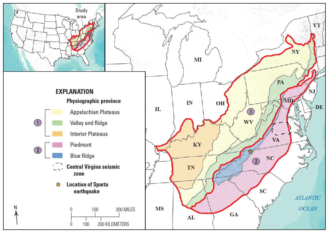
Physiographic regions of the Eastern United States, excluding New England. The Piedmont and Blue Ridge, labelled 2 here and in subsequent figures, is the focus of this chapter. [AL, Alabama; DE, Delaware; GA, Georgia; IL, Illinois; IN, Indiana; KY, Kentucky; MD, Maryland; MI, Michigan; MS, Mississippi; NJ, New Jersey; NY, New York; NC, North Carolina; OH, Ohio; PA, Pennsylvania; SC, South Carolina; TN, Tennessee; VA, Virginia; WV, West Virginia]
The geologic framework of the Piedmont and Blue Ridge Provinces is interconnected; geologic units and terranes of the Blue Ridge may also occur within the Piedmont Province. The Blue Ridge is thrust over Paleozoic strata of the Valley and Ridge to the west, whereas the rocks of the Piedmont continue in the subsurface beneath the Atlantic Coastal Plain onlap. Mesozoic rift basins overlie parts of the Piedmont crystalline rocks and contain hundreds to thousands of meters of Early Triassic to Early Jurassic sediment and igneous rocks (Olsen and others, 1991). The Piedmont and Blue Ridge consist of complex, polydeformed Mesoproterozoic to Paleozoic crystalline rocks, and comprise various lithostratigraphic terranes that were assembled during multiple orogenies (Hibbard and others, 2006; Hatcher and others, 2007; Hatcher, 2010). Collectively, the orogenies experienced by the Piedmont and Blue Ridge Provinces include the Grenville orogeny (1.3–1.0 Ga), Taconic orogeny (460–450 Ma), Acadian/Neoacadian orogeny (395–340 Ma), and Alleghanian orogeny (335–260 Ma) (Hatcher and others, 2007; Hibbard and others, 2007, 2010; Hatcher, 2010; Merschat and others, 2017). These orogenic events were punctuated by episodes of extension, including intracontinental rifting (780–750 Ma), breakup of Rodinia and the opening of the Iapetus Ocean (~570 Ma), and finally the breakup of Pangea and the opening of the modern Atlantic Ocean (~200 Ma) (Hatcher and others, 2007; Hatcher, 2010; Ma and others, 2019)79.
The oldest rocks are 1.3–1.0 Ga crystalline gneisses and granitoids, Grenville basement, exposed in various massifs in the Blue Ridge and Piedmont (Southworth and others, 2010; Tollo and others, 2010, 2017). Neoproterozoic to Paleozoic metasedimentary and metavolcanic rocks constitute the majority of the different Appalachian terranes, both Laurentian and exotic (peri-Gondwanan affinity) and record the episodic accretion and collision of various terranes throughout Mesoproterozoic to Paleozoic time (Hibbard and others, 2006; Hatcher and others, 2007). These orogenic events formed various magmatic/volcanic belts throughout the Piedmont and Blue Ridge. Many factors—tectonic inheritance, geometry of collision, melt-weakened crust—affected the strain patterns and crustal structure throughout the Piedmont and Blue Ridge. Successive tectonic events may have reactivated and (or) overprinted earlier structures. Metamorphism and heat from intrusive rocks may have provided energy to drive metamorphic reactions, localize mineral deposits, or further control regional strain patterns. Detailed geologic mapping and framework studies are required to address these complex geologic problems.
The polydeformed history of the Appalachian orogen creates multiple geologic opportunities for the formation of economic ore deposits, concentrations of radiogenic or other materials that may be harmful when exposed to the public and form structures that may produce geohazards (mass wasting or intraplate seismicity). A sustained and active geologic mapping program provides clear societal and economic benefits to address these issues (for example, Bernknopf and others, 1993; Bhagwat and Ipe, 2000; Cobb, 2002; Thomas, 2004; Hornberger and others, 2006; Häggquist and Söderholm, 2015). The continued acquisition of new geologic data and new geologic mapping (scales 1:24,000 to 1:100,000) is necessary to maintain a vibrant geologic mapping program that can produce geologic maps to meet the needs of society. The renewed vision, mission, and goals of the NCGMP (Brock and others, 2021) recognizes the need for continued geologic mapping at scales of 1:24,000 and 1:100,000 and advocates (1) strong program level partnerships among stakeholders, and (2) utilizing new technologies—both required to achieve a goal of a seamless 3D national geologic map by 2030. The Piedmont and Blue Ridge implementation plan discusses the future of geologic mapping and framework research in the Piedmont and Blue Ridge Provinces, will guide the Annual FEDMAP Prospectus, and may help STATEMAP (that is, the component of the USGS NCGMP that funds geologic mapping by State Geological Surveys) Advisory Committees in planning, as well as in developing effective communication and partnerships.
Status of Topographic and Geologic Mapping
For the Piedmont and Blue Ridge Province, there are 1:24,000 scale 7.5-minute topographic quadrangles, which have been revised within the last 30 years, and digital US Topo maps for the entire area.
Various regional-scale geologic maps cover the Piedmont and Blue Ridge provinces (fig. 2) and include State geologic maps (scale 1:500,000) and several published 1° x 2° sheets (Hadley and Nelson, 1971; Rankin and others, 1972; Espenshade and others, 1975; Goldsmith and others, 1988; Nelson and others, 1998). Most of these maps were published before the advancements of modern geochronology studies/techniques in the 2000s; reported absolute ages for crystalline rock units in these maps are sparse and, in some instances, questionable. Coverage at scales between 1:100,000 and 1:24,000 varies from areas having several published maps that adjoin or overlap (fig. 2; see Piedmont and Blue Ridge of South Carolina or Pennsylvania) to areas lacking any published mapping beyond regional scales of 1:250,000 or smaller. Areas lacking significant mapping at scales greater than 1:250,000 are (I) Piedmont in southeastern Virginia and adjoining North Carolina; (II) Blue Ridge of southwestern Virginia into the Piedmont of western-central North Carolina; (III) Piedmont of northeastern South Carolina; (IV) large portions of the Blue Ridge and Piedmont in northern, eastern, and southwestern Georgia; (V) and the southeastern part of the Piedmont in Alabama and adjoining Georgia (fig. 2; note that fig. 2 does not include recent academic work in the Piedmont and Blue Ridge; for example, Huebner and others, 2014; Crawford and Kath, 2015; Barineau and others, 2017).
Synopsis of Recent NCGMP-Sponsored Science and Mapping
The NCGMP supports geologic mapping and research in the Piedmont and Blue Ridge at 1:24,000-scale, including framework geochronologic studies. Previous FEDMAP-supported projects in the Piedmont and Blue Ridge are the Blue Ridge Project and Central Virginia Seismic Zone Project (fig. 3). The Blue Ridge Project published a new geologic map of the Great Smoky Mountains National Park and vicinity (Southworth and others, 2012), an online geologic map of the Blue Ridge Parkway in Virginia (Carter and others, 2016a), and a published geologic map of Mount Rogers and vicinity is planned. Several journal articles were published on the geochronology of Blue Ridge basement rocks (Aleinikoff and others, 2013; Tollo and others, 2017), and the spatial and temporal distribution of Paleozoic metamorphism in the Blue Ridge and Piedmont of North and South Carolina (Merschat and others, 2017). Seven geologic field trip guides were presented (Tollo and others, 2012; Carter and others, 2013, 2017; Carter and Merschat, 2014; Merschat and others 2014, 2016; 2018). Geologic mapping in the Virginia Piedmont, Central Virginia Seismic Zone (CVSZ), began in response to the 2011 Mineral, Va., earthquake (for example, Carter and others, 2012; Harrison and others, 2012; Horton and Williams, 2012). This effort resulted in seven published 7.5-minute maps (Spears and others, 2013; Evans, 2017; Burton, 2019; Burton and others, 2019; Carter and others, 2019) a combined effort with Virginia Department of Energy—Geology and Mineral Resources Program, a Geological Society of America Special Paper 509 (Horton and others, 2015a), which contains a collection of research papers including eight co-authored by USGS CVSZ project personnel (Berti and others, 2015; Burton and others, 2015; Green and others, 2015; Horton and others, 2015b, 2015c; Powars and others, 2015; Pratt and others, 2015; Shah and others, 2015) on the Mineral, Virginia earthquake, three field trip guidebooks (Burton and others, 2014; Hughes and others, 2014; Pazzaglia and others, 2015), and a USGS Open-File Report (Harrison and others, 2016).
Description of Lidar Mapping Status
Light detection and ranging (lidar) mapping is nearly complete across the Piedmont and Blue Ridge of North Carolina and Virginia, with minor coverage gaps in northern Virginia and Maryland (fig. 3). Whereas most of these lidar data were collected through 3D Elevation Program (3DEP) partnerships, primarily with the Natural Resources Conservation Service and are of QL2 quality, QL1 lidar data were collected in the Central Virginia Seismic Zone following the 2011 Mineral Virginia earthquake, and have been extensively used for geologic mapping and seismic hazard research there (for example, Pazzaglia and others, 2015; Witt and Carter, 2016). Recently, QL0 lidar data were collected over Sparta, North Carolina, in response to the Mw 5.1 earthquake on August 9, 2020. The Piedmont and Blue Ridge in Alabama is covered from FY 2020 3DEP partnerships. In Georgia and a few small areas in South Carolina, lidar coverage contains some gaps or holes, which currently do not have planned funding (fig. 3).The small extent of the Piedmont and Blue Ridge in Pennsylvania is covered with lidar (fig. 3).
Status of Geophysical Surveys
Regional potential field geophysical data (aeromagnetic and gravity surveys) were acquired during the 1960s to 1980s, with most of the aeromagnetic data collected during the 1970s as part of the National Uranium Resource Evaluation (Hill and others, 2009; fig. 4). National Uranium Resource Evaluation flight lines were spaced 1 to 3 miles apart. Modern, digitally acquired aeromagnetic surveys with a flight spacing of 0.5 mile or less are sparse. Modern aeromagnetic data were collected in parts of southeastern Virginia and northeastern North Carolina in 1994 with a 0.5-mile spacing (Horton and Daniels, 1999); between Maryville, Tennessee, and Asheville, N.C., in 2003 with a 0.33-mile flight spacing (Daniels, 2002); and in part of the CVSZ in 2012 with a 200-meter flight spacing (Shah and others, 2015). Airborne spectral radiometric (gamma ray spectrometry) data for potassium, uranium, and thorium decay products were simultaneously acquired in the latter two examples. Airborne gravity measurements were also collected across the CVSZ (Shah and others, 2015). Additional modern aeromagnetic data may exist locally (county or municipalities, and so forth), but are not listed herein. Seismic reflection lines (Consortium for Continental Reflection Profiling), collected during the 1970s to 1980s, transect different segments of the Piedmont and Blue Ridge from Alabama to Pennsylvania, and a USGS profile along U.S. Interstate 64 in Virginia extends from the Valley and Ridge to the coast (Pratt and others, 1988). These geophysical data have been reprocessed and interpreted by various studies (Hatcher and others, 2007; Pratt and others, 2015; Duff and Kellogg, 2017). The EARTHSCOPE flexible array covered the Piedmont and Blue Ridge from 2003 to 2013, and provides new geophysical data related to deeper lithospheric structure. Many studies have used gravity and aeromagnetic studies to identify geologic structures in the Blue Ridge and Piedmont (Hatcher and others, 2007; Huebner and others, 2014), and more recently Shah and others (2017) used these datasets to identify rare earth element (REE) deposits in the Coastal Plain. Shah and others (2017) demonstrated the benefits of applying existing airborne geophysical studies, and the need for modern geophysical data combined with detailed field mapping to better assess and locate new critical mineral deposits in the Atlantic Coastal Plain.
The Earth Mapping Resource Initiative (MRI) is providing an opportunity to acquire modern potential field geophysics in the Piedmont and Blue Ridge. New airborne magnetic and radiometric data collected over the Piedmont and Coastal Plain of South Carolina (fig. 4) provide detail of poorly exposed crystalline terranes of the Piedmont and provide a unique source-to-sink approach to examine potential REE deposits in the Coastal Plain (Shah and others, 2021). In southeastern Virginia and northeastern North Carolina, a similar Earth MRI study acquired new modern geophysical data over the Piedmont and Coastal Plain in 2021 (fig. 4). These surveys will provide an enhanced detail of the crystalline structure of the Piedmont in these areas and highlight the value of more modern geophysical surveys over the Piedmont and Blue Ridge (for example, Shah and others, 2022).
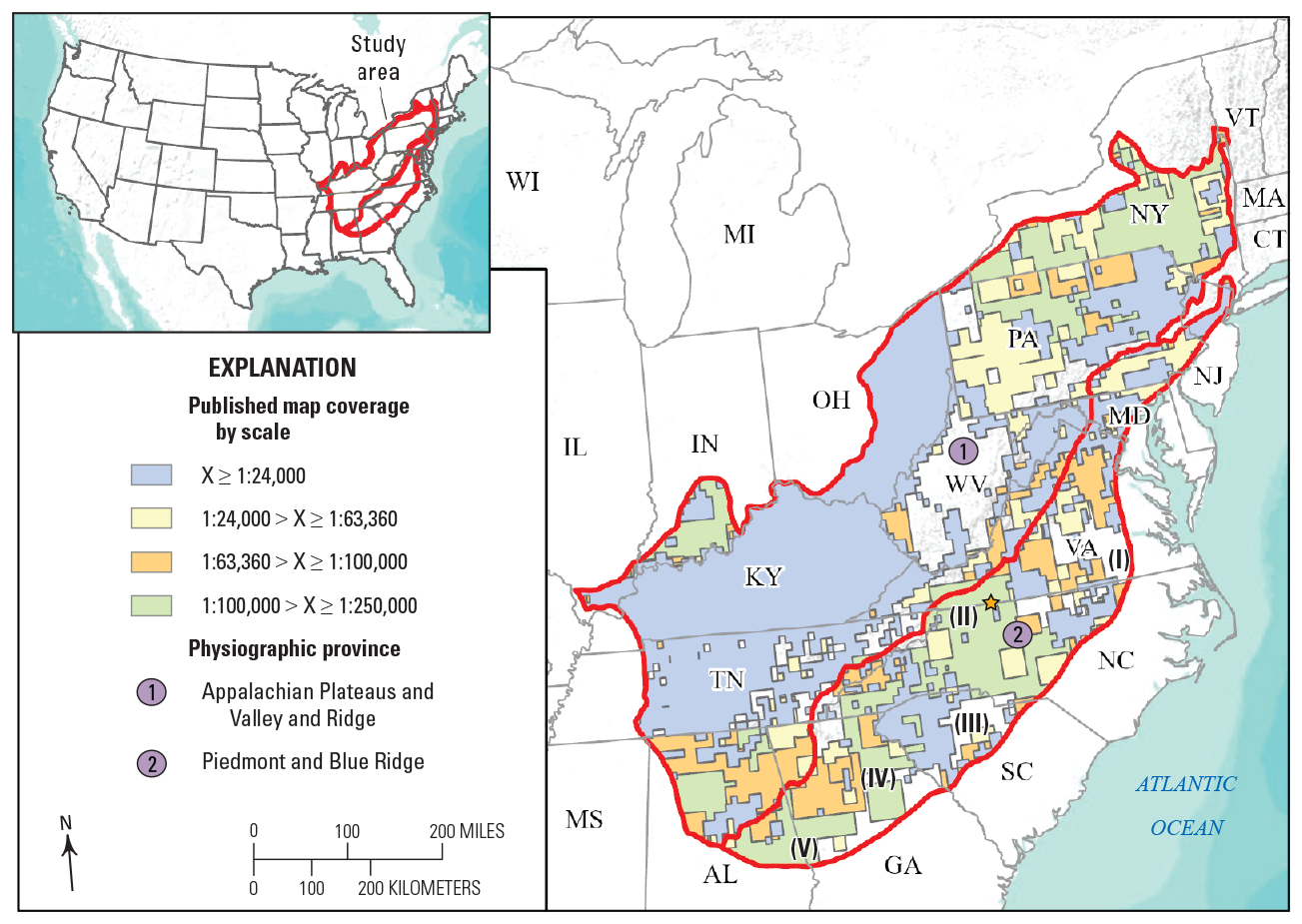
Distribution of published geologic maps in the Blue Ridge and Piedmont Provinces, and Plateaus and Valley and Ridge regions. The Roman numerals in parentheses correspond to areas lacking significant published geologic maps beyond scales of 1:250,000 or smaller. See text for discussion. [AL, Alabama; DE, Delaware; GA, Georgia; IL, Illinois; IN, Indiana; KY, Kentucky; MD, Maryland; MI, Michigan; MS, Mississippi; NJ, New Jersey; NY, New York; NC, North Carolina; OH, Ohio; PA, Pennsylvania; SC, South Carolina; TN, Tennessee; VA, Virginia; WV, West Virginia]
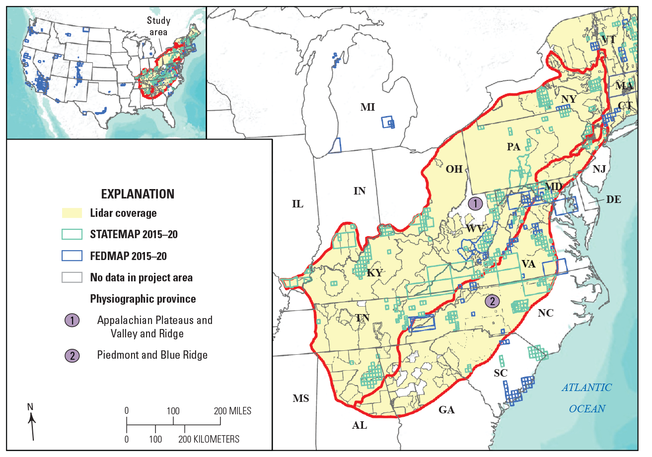
Light detection and ranging (lidar) coverage, QL2 or better, in the Piedmont and Blue Ridge Provinces, and the footprints of FEDMAP and STATEMAP-funded mapping efforts from 2012 to 2020 (includes footprints of active mapping projects described herein, 2019–20). [AL, Alabama; DE, Delaware; GA, Georgia; IL, Illinois; IN, Indiana; KY, Kentucky; MD, Maryland; MI, Michigan; MS, Mississippi; NJ, New Jersey; NY, New York; NC, North Carolina; OH, Ohio; PA, Pennsylvania; SC, South Carolina; TN, Tennessee; VA, Virginia; WV, West Virginia; WI, Wisconsin]
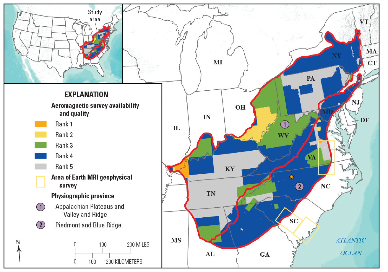
Existing aeromagnetic surveys across the Eastern United States. Footprints of Rank 1 Earth Mapping Resource Initiative (MRI) geophysical surveys, acquired 2019–21, are shown in yellow. Map data obtained from U.S. Geological Survey (2021a, 2021b).
Scientific Relevance
Seamless Geologic Map Database
The Piedmont and Blue Ridge Provinces are well covered by geologic maps at 1:250,000 (about 50 percent) or smaller scale, including State geologic maps; however, most of these maps are more than 25 years old (fig. 5). Regionally, there are many inconsistencies between maps and at State borders, including mismatched contacts, faults, and units. Most maps lack modern uranium-lead (U-Pb) geochronology (fig. 5), which is a critical tool for resolving and quantifying ages of crystalline units in the complex terranes of the Piedmont and Blue Ridge (Merschat and others, 2017; Carter and others, 2020). Geologic mapping and framework analyses in the Piedmont and Blue Ridge Provinces are planned to (1) target areas that have only been examined at a reconnaissance scale (1:250,000 scale or smaller); (2) reconcile problems between State borders and other small-scale maps; (3) address regional correlation of map units and structures; and (4) target areas with important societal relevance (geologic hazards, mineral deposits, hydrogeologic and water quality, infrastructure, and so forth). Planned mapping efforts consist of new detailed 1:24,000 scale in targeted quadrangles and reconnaissance mapping in other areas and involve collaboration with State geological surveys and academic institutions to map and compile new and existing geologic maps in targeted areas at a scale of 1:100,000. Framework geochronologic and geochemical studies can help to address key problems (points 1–4). The goal is to develop a seamless geologic map across the Piedmont and Blue Ridge to better reconcile map and State border issues; resolve regional- and orogen-scale correlation of map units (formations), structures, and other features; promote the mitigation of geologic hazards; aid in land-use planning; provide a framework for surface and groundwater studies; identify possible new mineral (critical, strategic or industrial) and aggregate deposits; and provide suitable data to help build a national 3D geologic model.
Tectonic Evolution
The Piedmont and Blue Ridge is a composite of numerous polydeformed terranes that were assembled during at least four orogenies—mountain-building events—from the Mesoproterozoic to the end of the Paleozoic, and three rifting or extensional events from the Neoproterozoic to Mesozoic (Hatcher and others, 2007; Hibbard and others 2007, 2010; Merschat and others, 2017). Collectively, these orogenic events are responsible for the crustal structure, fracture and fault zones, mineralization and ore deposits, geochemical, and geophysical properties of the Piedmont and Blue Ridge. Understanding these complex orogenic events and the tectonic processes involved—arc magmatism, mantle plumes, partial melting of the crust, and so forth—will help to better understand and locate ore deposits and mitigate geologic hazards. The magmatic, thermal, and deformational history of the Piedmont and Blue Ridge terranes controlled mineralization and formation of ore deposits. Magmatism, arc- or rift-related, localized gold and other precious metal mineralization, including massive sulfide deposits (for example, Ducktown, Tenn.; Cabarrus County, N.C.; Mineral, Va.). Major faults, which bound these terranes, developed highly foliated and (or) fractured rocks that are weak and more susceptible to landslides and other forms of mass wasting. Highly fractured rocks associated with faults may also be important aquifers and aquicludes (Johnson and Dunstan, 1998; Shapiro, 2002; Goode and others, 2007). Finally, geologic framework studies have identified the spatial relation among geologic/tectonic structures and the localization of intraplate earthquakes and seismic zones (for example, Hughes and others, 2014; Burton and others, 2015; Horton and others, 2017), 3D seismic-velocity structure of the Earth, and seismic hazards (Thomas and Powell, 2017). Additional tectonic themes identified by the working group include the following:
-
Tectonic inheritance and its effect on regional strain patterns and facies distribution (for example, Thomas, 2006)
-
Tectonic evolution of poorly known terranes and their boundaries (Shah and others, 2022)
-
Correlation of foreland and hinterland units and structures; connections in timing of events and tectonic setting (for example, Merschat and Hatcher, 2007)
-
Orogenic processes acting in the lower and middle crust (for example, orogenic channel flow, pluton emplacement, economic mineralization; Hatcher and Merschat, 2006; Merschat and others, 2017)
-
Tectonic transitions from late Paleozoic contraction to early Mesozoic extension (Horton and others, 2005; Owens and others, 2017; Ma and others, 2019)
-
Appalachian terranes and basins buried beneath sediments of the Atlantic Coastal Plain (among the last frontiers of regional geology in the Eastern United States) (Horton and others, 2005; 2016)
-
Bridging the gap between geology mapped at the Earth’s surface and deeper lithospheric structure as revealed by Earthscope (Aragon and others, 2017; Duff and Kellogg, 2017)
Landscape Evolution
Landscapes are important economic, societal, and geologic features that attract numerous visitors to national and State parks and support areas of fertile agricultural land, both of which bring commerce into surrounding areas. The landscape of the Piedmont and Blue Ridge, often generally considered to be geologically old (Hack, 1960; Matmon and others, 2003), is geologically young and dynamic (for example, Gallen and others, 2013; Pazzaglia and others, 2015, 2021). These landscapes are governed by various geologic, tectonic, biologic, climatic, and earth surface processes. Geologic mapping of surficial geology (surface and near-surface geology) can provide insight into the processes controlling the evolution of the Piedmont and Blue Ridge landscape, as well as provide critical information for land use and project planning by Federal, State, and County governments and private enterprises. Additionally, the Piedmont and Blue Ridge landscapes are home to insular ecosystems with direct geologic controls, Piedmont granite balds, and high-elevation outcrops and balds that contain rare and endemic plant taxa (Cartwright and Wolfe, 2016). Research into landscape evolution through targeted studies can help to understand the age of the topography, quantify recent uplift or erosion, and possibly identify crustal or mantle processes responsible for the rejuvenation of Piedmont and Blue Ridge topography (for example, Gallen and others, 2013; Pazzaglia and others, 2015, 2021). This research may further relate to the insular ecosystems and the understanding of intraplate earthquakes (for example, Berti and others, 2015; Figueiredo and others 2022).
Extensions of Piedmont Terranes Beneath the Coastal Plain
Extensions of Appalachian Piedmont geology concealed beneath the Atlantic Coastal Plain represent a research frontier, where geologic mapping has significant potential to provide new information on the tectonic assembly and Mesozoic breakup of the Appalachian orogen, as well as identify undiscovered mineral resources at accessible depths. Geologic mapping in the eastern Piedmont will build on results of the coastal-basement mapping project (https://www.usgs.gov/centers/florence-bascom-geoscience-center/science/coastal-basement-geology-southeastern-us-project) to help identify connections to subsurface crystalline terranes that can only be studied through a combination of borehole data; petrographic, geochemical, and geochronologic analyses of samples from existing drill cores and cuttings; and geophysical surveys.
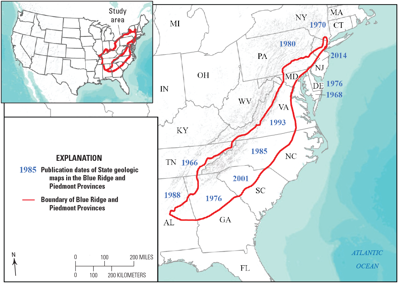
Publication dates of State geologic maps that cover the Piedmont and Blue Ridge Provinces. Most geologic maps are older than 25 years and were compiled before the revolution of uranium-lead geochronology, which has vastly improved our understanding of ages of crystalline rocks in the Piedmont and Blue Ridge. References for State geologic maps: Alabama—Szabo and others (1988); Delaware—Pickett and others (1976); Georgia—Lawton and others (1976), Maryland—Cleaves and others, (1968); New Jersey—Dalton and others (2014); New York—Rickard and others (1970); North Carolina—North Carolina Geological Survey (1985); South Carolina—Horton and Dicken (2001); Pennsylvania—Berg and others (1980); Tennessee—Hardeman (1966); and Virginia—Virginia Division of Mineral Resources (1993).
Societal Relevance
Natural Resources
The Piedmont and Blue Ridge Provinces contain abundant natural resources from economic mineral deposits to the existence of clean drinking water. The following sections address the societal relevance of geologic mapping for critical minerals, precious minerals and other mineral resources, energy resources, and surface water and groundwater resources.
Critical Minerals
In 2022 the updated list of critical mineral resources for the United States includes 50 minerals (U.S. Geological Survey, 2022) and many are described in USGS Professional Paper 1802 (Schulz and others, 2017). The Piedmont and Blue Ridge Provinces contain numerous critical mineral deposits that have been mined or prospected in the past and justify geologic mapping in these areas to provide framework geologic information regarding the nature and formation of these deposits. Critical mineral resources in the Piedmont and Blue Ridge include, but are not limited to, the following:
-
Barium: barite deposits in the Piedmont of South Carolina and Alabama (for example, Kings Creek, South Carolina), and Blue Ridge (for example, near Hot Springs, N.C., and Del Rio, Tennessee).
-
Beryllium: beryl in pegmatites in districts throughout Alabama, Georgia, North Carolina, and Virginia
-
Cobalt: skarn associated with Mesozoic diabase at Cornwall, Pennsylvania; cobalt in massive sulfide deposit of Lick Fork-Sugar Run in the Blue Ridge, Va.
-
Gallium: altered high-alumina metavolcanic rocks in South Carolina Piedmont
-
Graphite: Holy schist at Rosco Ridge, Alabama; schists at Dillinger mine, Yancey County, N.C., and Piedmont near Raleigh, N.C.
-
Lithium: spodumene bearing pegmatite, Kings Mountain and Bessemer City in North Carolina and South Carolina area; lithiophorite in Clay County, Ala.
-
Manganese: schists in the Grover and Martin mines, S.C.; nodules and breccias in Chilhowee Group, Shady dolomite and Rome Formation along Blue Ridge western front, Alabama to Virginia; pyrolusite associated with brown iron ore in the Talladega Slate Belt in Alabama; and residual concentrations of manganese related to the weathering of spessartine in the Ashland Super Group in Alabama
-
Rare-earth element bearing minerals (monazite and xenotime): two belts in high-grade schists and gneisses in Blue Ridge and Inner Piedmont, Georgia, North Carolina, and South Carolina; heavy mineral deposits along the Fall Line from Dinwiddie, Va., to Aurelian Springs, N.C., and South Carolina, to Georgia; columbite-tantalite series occur as accessory minerals in pegmatites in the Coosa County tin district in Alabama
-
Tin: cassiterite deposits in Kings Mountain tin-spodumene belt and Cherryville granite in North Carolina, and Rockford Granite in Alabama Piedmont; Irish Creek pluton in the Blue Ridge, Va.
-
Titanium: rutile from Roseland anorthosite in Virginia; prospects in schist and gneiss near Franklin, N.C.; ilmenite in heavy mineral placer deposits along the Fall Line from Dinwiddie, Va., to Aurelian Springs, N.C., and South Carolina to Georgia
-
Tungsten: Hamme District, Vance County, N.C.
-
Zirconium: Zircon in heavy mineral placer deposits along the Fall Line from Dinwiddie, Va., to Aurelian Springs, N.C., and South Carolina to Georgia; zircon bearing pegmatite in North Carolina Piedmont
-
Uranium: Coles Hill, Va.; Harpers Creek, N.C.
Precious Metals, Industrial Minerals, Dimension Stone, and Natural Aggregate
Discovery of gold in 1799 in the Piedmont Province of North Carolina led to the first gold rush in the United States and quickly spread to other locations in the Piedmont (South Carolina, Virginia) and Blue Ridge (for example, Dahlonega gold belt in Georgia), and then the Western United States (Stuckey, 1965). Additionally, copper was mined at several locations (for example, Ducktown, Tenn., and Ore Knob, N.C.). Other industrial mineral resources mined include feldspar, mica, kyanite, olivine, iron-sulfides, iron-oxides, magnetite, chromite, and ultra-high purity quartz. Many of these are concentrated in certain mining districts like the Spruce Pine or Kings Mountain districts, N.C., and the Mineral District in the Central Virginia Gold Belt. Devonian alaskitic pegmatite bodies in Spruce Pine were mined for feldspar, mica, beryllium, and now ultra-high purity quartz. Ultramafic bodies in the country rock (Ashe Metamorphic Suite) intruded by the pegmatites were mined for olivine, chromite, and asbestos minerals. In Virginia, copper was mined from the Glade District near Lynchburg. Dimension stone remains an important industry throughout the Piedmont and Blue Ridge, with many Piedmont and Blue Ridge rock units yielding high-quality material: Sylacauga Marble in Alabama, Kershaw granite, Liberty Hill pluton in South Carolina; and Mount Airy Granite in North Carolina. However, natural aggregate resources remain the most important geologic commodity for building and maintaining infrastructure in rapidly expanding population centers (Langer, 2011). Geologic mapping and framework studies can help to locate new ore deposits, better characterize known deposits, help identify potential rocks suitable for aggregate, and locate abandoned mines for possible hazard mitigation.
Energy Resources
Triassic rift basins distributed throughout the Piedmont provide potential energy resources in the form of coal and natural gas until replaced by cleaner renewable energy sources. Bituminous coal was commercially mined during the 1800s to 1950s and reserves remain (Textoris and Robbins, 1988). The abandoned mines, however, represent potential hazards for collapse, sink holes, fall dangers, and others. Natural gas trapped in organic shales within the basins is a potential energy resource (Reid and Milici, 2008). Development of natural gas resources, however, may have potential negative effects on water quality.
Surface Water and Groundwater Resources
Surface water and groundwater resources remain the most important societal needs even in wet climates (greater than 30 inches of average annual precipitation) of the Eastern United States (Evenson and others, 2013; Dieter and others, 2018). In 2015, an estimated 283 million people in the United States—87 percent of the total population—relied on public-supply water from surface water (61 percent) and groundwater (39 percent) for household consumption (Dieter and others, 2018). Geologic mapping and geochemistry provide information about the fractured-rock aquifer properties, water quality and availability, and naturally occurring and anthropogenic contaminants (Ayotte and others, 2011; Evenson and others, 2013; DeSimone and others, 2014). Groundwater wells in portions of the Piedmont and Blue Ridge may have elevated levels of arsenic, chromium, cerium, gallium, and other naturally occurring harmful contaminants (Ayotte and others, 2011; Bradley and Campbell, 2012; DeSimone and others, 2014). Characterizing the framework geology can provide critical information to resource managers responsible for maintaining clean drinking water for the Nation (Evenson and others, 2013; DeSimone and others, 2014).
Geologic Hazards
The Piedmont and Blue Ridge contain numerous geologic hazards, such as groundwater quality, mass wasting processes, naturally occurring radon, karst, and intraplate seismicity. Moreover, certain areas may be more susceptible to different hazards than others. For example, mass wasting (landslides and rock falls) are more common on the steep terrain of the Blue Ridge; however, slope stability problems and landslides associated with highly fractured or foliated fault zone rocks may occur throughout the Blue Ridge or Piedmont (fig. 6; Wooten and others, 2008, 2016). Likewise, average indoor radon levels by county are reported as moderate (2–4 picocuries per liter) to high (greater than 4 picocuries per liter) throughout most of the Piedmont and Blue Ridge. Groundwater wells in portions of the Piedmont and Blue Ridge also have elevated levels of radon (Ayotte and others, 2011; Bradley and Campbell, 2012). Higher levels of radon may be associated with different rock types (black shales, volcanic rocks, granitic plutonic rocks) or concentrated in fault zones, which are delimited through detailed mapping and ancillary studies. Karst (fig. 6C), although minor in these provinces, remains an important geologic hazard locally. Karst features occur along the western part of the Blue Ridge in windows through the Blue Ridge thrust sheet (for example, Mountain City window, and Tuckaleechee Cove window in Tennessee); the Murphy syncline in southwestern North Carolina and northeastern Georgia; the Sylacauga marble in the Talladega belt in Alabama; and the James River synclinorium in central Virginia.
Seismicity across the Piedmont and Blue Ridge is diffuse and infrequent, and yet the occurrence of two earthquakes greater than M5 in the past decade have demonstrated the importance of studying intraplate seismicity (fig. 1) (Bollinger, 1973; Stover and Coffman, 1993; Horton and others, 2015; Figueiredo and others, 2022). Renewed interest in seismic research in the CVSZ following the August 23, 2011, Mw5.8 quake (for example, Horton and others, 2015a) has led to many new research discoveries and directions. Exploration for seismogenic paleoliquefaction features (Tuttle and others, 2015; Carter and others, 2016b, 2020; Carter and McLaurin, 2019; Tuttle and others, 2021) identified more than two dozen potential paleoliquefaction sites and extends the CVSZ paleoliquefaction field to a maximum distance between liquefaction features (Re) to nearly 80 kilometers (Tuttle and others, 2021). However, the number (and location) of potential active faults in the CVSZ, and the largest magnitude quake these faults are capable of producing, remains elusive. In the Blue Ridge, the August 9, 2020, Mw 5.1 earthquake in Sparta, N.C., damaged more than 500 structures and generated surface rupture, which was the first documented in the Eastern United States (for example, Figueiredo and others, 2020, 202243; Hill and others, 2020; Merschat and others, 2020). The main co-seismic surface fault, named the Little River fault, and deformation were identified along a 2-kilometer-long traceable zone of predominantly reverse displacement, with folding and flexure generating a scarp averaging 8–10 centimeters high with a maximum height of about 50 centimeters (fig 6D, E). The Little River fault strikes 100 degrees to 110 degrees, dips to the southwest, and transects regional structures and contacts; however, a subset of joints and brittle faults are parallel to the fault (Merschat and others, 2020; Merschat and Carter, 2022). Despite these recent advances in the understanding of intraplate earthquakes, there remains much to be learned about the connection between the bedrock geology and possible seismogenic structures in the Piedmont and Blue Ridge.
Geologic hazards are potentially damaging to infrastructure and human life. New geologic mapping combined with acquired 3DEP lidar continues to provide new data about the underlying geology, structure, rock types, and surface topography, and how these factors control naturally occurring geologic hazards.
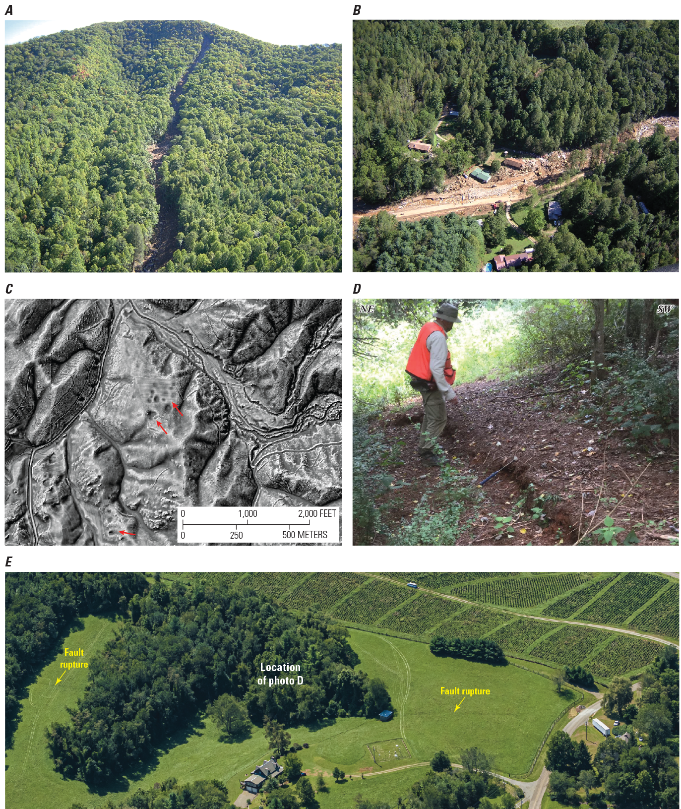
Geohazards in the Piedmont and Blue Ridge Provinces. A, Scarp and upper track on Fishhawk Mountain of the Peeks Creek debris flow in Macon County, North Carolina. B, Lower track of the Peeks Creek debris flow shows damaged and destroyed homes and deposition of flow material. The debris flow was triggered by high rainfall from the Hurricane Ivan, September 16, 2004. For additional information see Wooten and others (2008). Photographs in A and B by Rick Wooten, North Carolina Geological Survey, September 19, 2004. C, Sinkholes are developed in the Shady Dolomite in the Blue Ridge northeast Tennessee. Light detection and ranging (lidar) processed to enhance topography by Caitlin Burke (U.S. Geological Survey). D, Scarp of the Littler River fault produced by the August 9, 2020, Mw 5.1 earthquake in Sparta, North Carolina. The surface rupture extends as disconnected segments for about 2 kilometers with 5–10 centimeters of reverse displacement with southwest side up; view is looking to the east-southeast. E, High-oblique aerial image of Rivers Edge Road, Sparta, North Carolina, acquired on September 7, 2020, 1:600 scale, about 3 inches (7.98 centimeters) pixel resolution. The surface rupture is marked with yellow arrows and the location of (D) is shown.
Scientific Objectives
The primary scientific objective of geologic mapping in the Piedmont and Blue Ridge is to understand the geologic framework and tectonic evolution of terranes and basins in the Appalachian Piedmont and Blue Ridge. Data generated and gleaned from framework mapping and research can be directly applied to water, mineral, and energy resources; natural hazards; and engineering applications related to infrastructure. These scientific objectives are organized into two primary projects or tasks, East (Piedmont geology along the southeastern fall zone, Virginia and North Carolina [PIGONSOFA]) and West (Blue Ridge–Inner Piedmont [BRIP]), that will work toward each other to cover areas of needed mapping (fig. 7). Additional potential projects or tasks to develop include collaboration with STATEMAP, EDMAP, and FEDMAP partners to resolve correlation and edge-matching issues in the (1) Piedmont and Blue Ridge of northern Virginia–Maryland–Pennsylvania–Delaware; and (2) the correlation of Blue Ridge and Piedmont geology across the Alabama–Georgia and Georgia–South Carolina State lines. Collectively, these projects or tasks can help to characterize the geologic framework of the Piedmont and Blue Ridge, to produce detailed geologic maps (1:24,000 and 1:100,000) and geodatabases, to document the availability of natural resources, to understand or recognize potential natural hazards, to apply advanced technology to resolve geologic problems, and to develop a flexible and diverse workforce of geologic mappers for the future. These goals permeate through all phases of the implementation plan, map objectives, and deliverables.
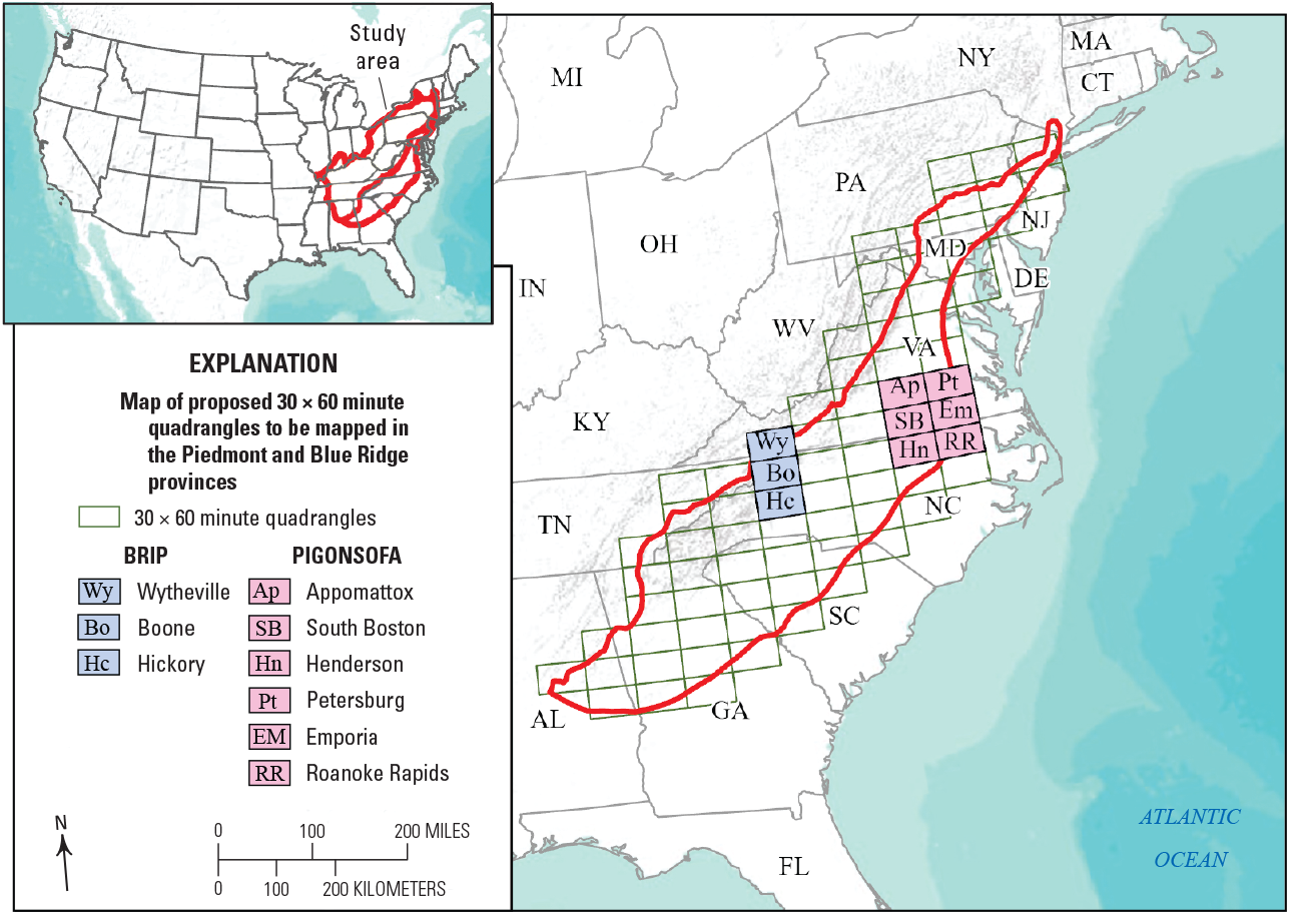
Map of the Piedmont and Blue Ridge Provinces indicating the proposed 30x60-minute sheets to be mapped. [PIGONSOFA, Piedmont geology along the southeastern fall zone, Virginia, and North Carolina; BRIP, Blue Ridge–Inner Piedmont]
Geologic Mapping Objectives
Geologic mapping objectives involve an initial stage of scoping, compilation, and assessment of existing mapping to identify areas where additional mapping is needed to resolve problems and (or) build cornerstones or islands of knowledge. Initial geochronology targets are planned to be identified, collected, and dated. Mapping plans extend away from cornerstones or islands of knowledge. Cornerstone maps will likely be at a scale of 1:24,000, and mapping away from the cornerstones may still be at 1:24,000 scale but will be compiled at 1:100,000 scale. Additional geochronologic targets identified during mapping are planned to be dated; geochemical samples will be collected and analyzed. To accomplish these objectives, East (PIGONSOFA) and West (BRIP) projects will work in concert to address framework geologic problems in the Piedmont and Blue Ridge of Virginia, North Carolina, and Tennessee, and to create an east-west transect of new geologic maps along the Virginia-North Carolina-Tennessee state borders where only limited data currently exist (fig. 7).
East (PIGONSOFA)
Phase 1
-
Complete geologic mapping of South Boston (Horton and others, 2022) and Emporia 30x60-minute quads along and across the Virginia-North Carolina border at 1:100,000 scale.
-
Continue to assist VGMR with geologic mapping and expertise in the Richmond metropolitan statistical area and on the Petersburg 30x60-minute quad (adjacent to the north of Emporia 30x60-minute quad) to further the goals and objectives of VGMR and their STATEMAP Program.
-
Geologic research on the Emporia 30x60-minute quad consisting of three types of studies: (1) Bedrock framework studies involving geologic mapping and compilation, coupled with collection of modern geochronologic and geochemical suites of targets identified during mapping, to determine the provenance, tectonic, and amalgamation histories of eastern Piedmont terranes in southeastern Virginia. The primary anticipated benefits of this bedrock framework are an improved understanding of critical/strategic mineral resource potential, evaluation, and genetic modeling (for example, identification of Piedmont bedrock deposits that directly contributed to heavy mineral sand accumulation in the inner Coastal Plain just east of the Fall Line from Dinwiddie, Va., to Aurelian Springs, N.C.). (2) Surficial framework studies, also derived from geologic mapping and optically stimulated luminescence (OSL)/radiocarbon geochronology, primarily to link Coastal Plain marine units with their age-equivalent fluvial deposits along ancient and modern riverine drainages (for example, Carter and others, 2007). A primary anticipated benefit of this surficial framework is an improved understanding of aggregate (sand and gravel) resource potential and evaluation (for example, identification of surficial deposits of proper engineering characteristics and extent that could be used as a local source for concrete). (3) Regional seismic hazards studies to enhance the dataset of paleoliquefaction meizoseismal fields associated with large magnitude earthquakes in the CVSZ. Currently (2021), the southern boundary of the CVSZ, based on the areal extent of paleoliqufaction features, is unknown. Additional exploration and geochronologic work in this area may contribute to estimates of the magnitude, age, and recurrence intervals of large-magnitude paleoearthquakes already established in the central portion of the CVSZ.
-
Work with the coastal-basement geologic mapping project to help correlation of Appalachian Piedmont geology with different terranes and structures concealed beneath coastal-plain sediments. The goals of the collaboration include (1) extending coastal-basement geologic mapping southward; (2) helping to understand the geologic framework and tectonic evolution of geologic terranes and basins beneath the coastal plain of the southeastern United States, and their significance for water, mineral, and energy resources; natural hazards; and engineering applications; and (3) addressing first-order scientific issues such as those related to tectonic evolution of poorly characterized geologic and tectonic domains, including the transition from late Paleozoic transpression to early Mesozoic extension, tectonic (fault) inheritance, and earthquake hazards.
Phase 2
-
Complete geologic mapping of Piedmont portion of Roanoke Rapids 30x60-minute quad (adjacent to south of Emporia 30x60-minute quad) at 1:100K scale per the three-pronged work plan, above.
-
Continue to assist VGMR with geologic mapping and expertise in the Richmond metropolitan statistical area and on the Petersburg 30x60-minute quad (adjacent to the north of Emporia 30x60-minute quad) to further the goals and objectives of VGMR and their STATEMAP Program.
Phase 3
-
Working west through the South Boston and Danville 30x60 minute quads, link with and assist BRIP staff with regional stratigraphic issues related to the Ashe-Alligator Back-Lynchburg-central and western Virginia Piedmont terranes, to resolve orogen-scale stratigraphic and tectonic problems on the Galax 30x60-minute quadrangle.
-
Assist North Carolina Geological Survey (NCGS) with any geologic mapping and expertise in the Henderson, Greensboro, and (or) Winston-Salem 30x60-minute quads to further the goals of NCGS and their STATEMAP Program.
West (BRIP)
Phase 1
-
Compile existing 1:24,000 and 1:48,000 scale mapping in the Wytheville 30x60-minute quadrangle, Virginia-Tennessee-North Carolina, in collaboration with VGMR, Tennessee Division of Geology (TDG), and NCGS.
-
Expand mapping from islands of detailed work: Mount Rogers area (eight 7.5-minute quads), Sparta East and West 7.5-minute quadrangles, VGMR I-81 Corridor STATEMAP project, and geologic mapping in northeastern Tennessee (USGS, King and Ferguson, 1960).
-
Address stratigraphic correlation problems: Ashe, Lynchburg, and Alligator Back Formations (metamorphic suites), and correlation of Grenville basement units between French Broad and Shenandoah massifs.
-
Work with State surveys (VGMR, NCGS and TDG) to identify remaining geochronology and geochemistry targets, and then collect and analyze.
-
Begin compilation of Hickory 30x60-minute quadrangle: compilation of existing USGS (Bryant and Reed, 1970) and EDMAP (that is, the component of the USGS NCGMP that funds geologic mapping by university and college students) maps (projects from 1998 to 2012).
-
Complete the Wytheville 30x60-minute quadrangle. Primary benefits include (1) natural resource evaluation of the entire Mount Rogers National Recreational Area and portions of the Appalachian Trail; (2) natural resource evaluation of Jefferson and Cherokee National Forests, Virginia and Tennessee; (3) support of infrastructure in I-81 corridor (location of aggregates, and identification of potential geologic hazards associated with roadcuts); and (4) resolve edge-mapping problems of structures and stratigraphy in three-state corner of Virginia, Tennessee, and North Carolina.
-
Reconnaissance in Virginia–Maryland–Pennsylvania–Delaware Piedmont.
Phase 2
-
Mapping at 1:24,000 scale in selected areas in Hickory 30x60-minute quadrangle.
-
Identify and study areas of critical mineral deposits: use lidar to identify past REE prospects, pits, and mines in South Mountains and occurrences throughout Inner Piedmont, map surficial deposits aided by lidar with a focus on areas of mined placer deposits, and examine occurrence and genesis of lithium (spodumene) deposits near Taylorsville, N.C., gold in South Mountains and other mineral resources.
-
U-Pb geochronology of granitoids, and detrital zircon geochronology of metasedimentary rocks.
-
OSL ages of surficial deposits (placer deposits), and apatite and zircon fission track ages across Piedmont.
-
Analyses of kinematic, mechanical, and timing relations of structures and faults in the Blue Ridge and Inner Piedmont: (1) mid-crustal flow during the middle Paleozoic and comparison with orogenic channel flow models (partnership with University of Kentucky); and (2) kinematics and timing of Brevard fault zone and Linville Falls fault (argon/argon [Ar/Ar] thermochronology).
-
Complete Hickory 30x60-minute quadrangle. Primary benefits include (1) assessment of critical minerals (rare earth potential of monazite and xenotime, and lithium-bearing minerals) in high-grade gneisses and schists, and felsic plutonic rocks of the Inner Piedmont; (2) assessment of surface-water and groundwater quality of the Catawba River-Lake Norman Reservoir, which supplies drinking water to Charlotte, N.C., and smaller cities of Hickory, and Statesville, N.C.; (3) mapped surficial deposits and locations of abandoned mines, and prospects; (4) modern geochronologic ages of Neoproterozoic Crossnore plutonic rocks in the Grandfather Mountain window, and various Paleozoic granitoids throughout the Inner Piedmont; and (5) improved kinematic and mechanical models of mid-crustal deformation and ductile flow in the Inner Piedmont, and timing and kinematics of the Brevard fault zone and Linville Falls fault.
-
Edge mapping in Virginia–Maryland–Pennsylvania–Delaware Piedmont.
Phase 3
-
Compilation of Boone and Galax 30x60-minute quadrangles in North Carolina-Tennessee, and Virginia with collaboration with NCGS, TDG, and VGMR.
-
Identify targets for geochronology (U-Pb and Ar/Ar).
-
Mapping in the Boone and Galax 30x60-minute quadrangles: eastern Blue Ridge stratigraphic relations, and Lynchburg, Ashe, and Alligator Back formations (metamorphic suites).
-
Continue mapping potential REE deposits in northernmost Inner Piedmont in North Carolina, and continuation of major structures: Smith River allochthon southward into North Carolina, and Brevard fault zone into Virginia (Mountain Run fault?).
-
Collaborate with NCGS to compile existing surficial geologic maps (for example, Watauga County) and complete new surficial maps.
-
Complete the Boone and Galax 30x60-minute quadrangles. Primary benefits include (1) assessment of critical minerals (rare earth potential of monazite and xenotime, and lithium-bearing minerals) in high-grade gneisses and schists, and felsic plutonic rocks of the Inner Piedmont; (2) assessment of surface-water and groundwater quality of the Yadkin River, which supplies drinking water to the Winston-Salem, N.C.; (3) mapped surficial deposits, unstable slope deposits in the Blue Ridge, and potential rare earth placer deposits in Piedmont; (4) modern geochronologic ages of various granitoids throughout the Blue Ridge and Inner Piedmont; and (5) improved kinematic, mechanical models of midcrustal deformation and ductile flow in the Inner Piedmont, and timing and kinematics of the Brevard fault zone, Linville Falls fault, and Blue Ridge thrust sheet.
Capability Gaps
To maintain authoritative geologic expertise across multiple geologic terranes and states, the Piedmont and Blue Ridge Working Group recognizes several capability gaps for full implementation of the NCGMP Piedmont and Blue Ridge Project. These capabilities include staffing, laboratory, and technical expertise.
As currently envisioned, this plan lacks geologic mappers (2 or 3 full-time employees) with a variety of complementary skillsets (structural geology, stratigraphy, petrology, geochronology, geochemistry, geophysics, remotely sensed data and spatial data analysis, and 3D modeling) to complete mapping in the Piedmont and Blue Ridge. A solution involves the ability to identify, train/mentor, and hire talented geologic mappers with advanced-level degrees (Master of Science or Doctorate degree). Candidates may be identified through involvement in Youth and Education in Science, National Association of Geoscience Teachers, and cooperative agreements with the NCGMP to universities and colleges to support students to conduct geologic mapping and related field work (EDMAP). Involvement with EDMAP projects likely ensures greatest field experience and supports NCGMP goals. The current team is well positioned to provide mentorship to new geologic field mappers—as evidenced by their role in recent and ongoing EDMAP and STATEMAP projects. Mentorship is critical to engage and retain new talented mappers as volunteers, interns, or full-time employees. Mentor-protégée relationships between senior mappers or emeriti, and new hires, interns, and volunteers are valuable to the USGS and our partner agencies.
Likewise, the NCGMP and the project can continue to encourage early career and established faculty to participate in EDMAP projects related to or connected with FEDMAP projects. EDMAP remains one of the best avenues to train and develop new geologic mappers.
In support of geologic mapping, there exists a gap in petrologic, mineralogic, geochemical, and geochronologic expertise, as well as access to state-of-the-art laboratories and facilities. Some of this expertise can be gained though external collaboration; however, generally field-based research requires iterative and long-term approaches that may not be conducive to academic cycles (for example, a 2-year Master’s project). Additionally, external institutions may have different goals than those of the USGS and so the projects cannot rely solely on external collaboration for the application of analytical methods to field-based research. Therefore, in-house expertise in petrography, mineralogy, geochemistry, and geochronology is valuable to meet project goals. Access to laboratory instrumentation can help to provide robust data to address the various societal and scientific geologic problems in the Piedmont and Blue Ridge, and are critical for connecting field observation with quantitative analytical data about geologic materials. Ongoing or new collaborations may also provide opportunities for access to needed analytical instruments and laboratories.
Geochronology remains a core component in understanding the absolute age of framework bedrock geology, surficial deposits, and associated mineral deposits, as well as the rates of geologic processes. The geochronologic method, or technique, varies with each situation and problem, but in the Piedmont and Blue Ridge Project (and many NCGMP projects) U-Pb, 40Ar/39Ar, OSL, and cosmogenic nuclide methods commonly are required. Again, because USGS field-based research is iterative and driven by goals that may not align with other institutions, maintaining USGS expertise and laboratory capabilities in these commonly used geochronologic methods can help meet project goals.
Modern regional geophysics (especially magnetic, radiometric, and gravity) remain an important tool for geologists in crystalline terranes (Shah and others, 2015, 2017, 2021). Geophysical datasets become even more important in poorly exposed areas of the Piedmont and under the Coastal Plain. Modern geophysics could greatly enhance the results of geologic mapping in the Piedmont and Blue Ridge. Combined expertise in geophysics, 3D modeling, and geologic mapping could enhance the incorporation of new geophysical dataset into geologic maps and 3D geophysical models.
The need to integrate geospatial and remotely sensed data (lidar, geophysics) into geologic maps and 3D models is critical. In order to achieve the project goals outlined above, the expertise of geographic information system and data-management specialists with geologic mapping experience, in addition to geologists capable of working with geographic information systems, are vital.
Partners
The primary partners in the Blue Ridge and Piedmont Provinces include State geological surveys, collaborations with universities, other USGS programs and mission areas (Earthquake Hazards, Mineral Resources Program, Water Science Centers), Federal agencies (National Park Service, Nuclear Regulatory Commission, Federal Emergency Management Agency, U.S. Forest Service, U.S. Department of Agriculture, Department of Transportation, National Aeronautics and Space Administration, and so forth). Potential future collaborations include States, counties, and municipalities, and private-sector utilities and engineering firms.
Contacts (State Geologists or participants) at the State Surveys and other Federal agencies are listed by alphabetical order by State:
Alabama
Sandy Ebersole, State Geologist
Geological Survey of Alabama
205–247–3613; sebersole@gsa.state.al.us
G. Daniel Irvin
Geological Survey of Alabama
205–247–3542, dirvin@gsa.state.al.us
Dane S. VanDervoort
Geological Survey of Alabama
205–247–3626; dvandervoort@gsa.state.al.us
Delaware
William Schenck Scientist/Geologist
Delaware Geological Survey
257 Academy Street
University of Delaware
Newark, DE 19716-7501
Maryland
Rebecca Adams
Maryland Geological Survey
2300 St. Paul Street, Baltimore, MD 21218
Richard Ortt, Director
Maryland Geological Survey
2300 St. Paul Street
Baltimore, MD 21218
410-554-5503; richard.ortt@maryland.gov
North Carolina
Dr. Kenneth B. Taylor, State Geologist
North Carolina Department of Environmental Quality
Division of Energy, Mineral and Land Resources
North Carolina Geological Survey
512 North Salisbury Street, 1612 Mail Service Center
Raleigh, NC 27699-1612
919–707–9210; Kenneth.b.taylor@ncdenr.gov
South Carolina
Dr. Scott Howard
South Carolina Geological Survey
5 Geology Road
Columbia, SC 29212
803–896–7702; howards@dnr.sc.gov
Pennsylvania
Dr. Gale Blackmer, State Geologist
Department of Conservation and Natural Resources
Bureau of Geological Survey
3240 Schoolhouse Road
Middletown, PA 17057
717–702–2017; gblackmer@state.pa.us
Virginia
David Spears, State Geologist,
Virginia Department of Energy
Geology and Mineral Resources Program
900 Natural Resources Drive, Ste. 400
Charlottesville VA 22903
434–951–6350; david.spears@dmme.virginia.gov
Matthew Heller, Geologic Mapping Program Manager,
Virginia Department of Energy,
Geology and Mineral Resources Program
900 Natural Resources Drive, Ste. 500
Charlottesville VA 22903
434–951–6351; matt.heller@dmme.virginia.gov
Thomas Collins, Mineral and Geology Program Manager
George Washington and Jefferson National Forest Service
5162 Valleypointe Parkway
Roanoke, VA 24019
Anticipated Impacts
The anticipated impacts of geologic mapping in the Piedmont and Blue Ridge are wide-ranging from improved understanding of the tectonic history of the Appalachian orogen, to an increased understanding of potential geohazards from mass-wasting, to intraplate seismicity. Primary anticipated benefits include (1) a geologic mapping transect across the Virginia, North Carolina, and Tennessee borders to reconcile mismatched units and structures, and resolve lithostratigraphic correlations; (2) improved surface-water and groundwater quality including parts of the watersheds that supply drinking water to several large metropolitan areas (for example, Charlotte, N.C.) and the recharge area of a coastal aquifer for the a large part of Virginia Beach-Hampton Roads, Va.; (3) providing geologic maps for the assessment of natural resources and supporting Earth MRI for the location of critical minerals: rare earth minerals (monazite, xenotime, tantalite, columbite), lithium, tin, titanium, and graphite in high-grade gneisses and schists; plutonic rocks of the Piedmont and Blue Ridge; and placer deposits of the Fall line—a source to sink approach—as well as other critical minerals; (4) mapped surficial deposits to provide a better understanding of potential geohazards; critical information for project planning for Federal, State, County governments and private enterprises; possible economic placer deposits in Piedmont; and insight into the surface processes and the dynamic evolution of landscapes in the Piedmont and Blue Ridge; (5) modern geochronologic ages of various igneous rocks throughout the Piedmont and Blue Ridge; and (6) improved kinematic, mechanical models of midcrustal deformation and ductile flow in the Inner Piedmont, and timing and kinematics of the Brevard fault zone, Linville Falls fault, Blue Ridge thrust sheet, and eastern Piedmont fault system.
Acknowledgments
This report benefitted from the contributions and insights of the members of the 2018 Piedmont and Blue Ridge Working Group, and reviews by Victoria Langenheim, Kenzie Turner, and Jonathan Matti. The authors thank Lorrie Coiner Skiffington and Samantha Portnoy for support in creating the figures for this report.
References Cited
Aleinikoff, J.N., Southworth, S., and Merschat, A.J., 2013, Implications for late Grenvillian (Rigolet phase) construction of Rodinia using new U–Pb data from the Mars Hill terrane, Tennessee and North Carolina, United States: Geology, v. 41, no. 10, p. 1087–1090. [Also available at https://doi.org/10.1130/G34779.1.]
Aragon, J.C., Long, M.D., and Benoit, M.H., 2017, Lateral variations in SKS splitting across the MAGIC array, central Appalachians: Geochemistry, Geophysics, Geosystems, v. 18, no. 11, 20 p. [Also available at https://doi.org/10.1002/2017GC007169.]
Ayotte, J.D., Gronberg, J.M., and Apodaca, L.E., 2011, Trace elements and radon in groundwater across the United States, 1992–2003: U.S. Geological Survey Scientific Investigations Report 2011–5059, 115 p. [Also available at https://doi.org/10.3133/sir20115059.]
Barineau, C.I., Tull, J.F., Allison, D.T., and Holm-Denoma, C.S., 2017, Geologic map of the southernmost Appalachians of Alabama and Georgia—A synthesis of recent advances in mapping, geochemistry, geochronology, and tectonic interpretation: Geological Society of America Abstracts with Programs, v. 49, no. 7. [Also available at https://doi.org/10.1130/abs/2017SE-291649.]
Bernknopf, R.L., Brookshire, D.S., Soller, D.R., Mckee, M.J., Sutter, J.F., Matti, J.C., and Campbell, R.H., 1993, Societal value of geologic maps: U.S. Geological Survey Circular 1111, 60 p. [Also available at https://pubs.er.usgs.gov/publication/cir1111.]
Berti, C., Pazzaglia, F.J., Meltzer, A.S., and Harrison, R.J., 2015, Evidence for persistent, cumulative deformation of the Virginia Piedmont in the vicinity of the 23 August 2011 Mineral earthquake, in Horton, J.W., Jr., Chapman, M.C., and Green, R.A., eds., The 2011 Mineral, Virginia, earthquake and its significance for seismic hazards in Eastern North America: Geological Society of America Special Paper 509, p. 377–390. [Also available at https://doi.org/10.1130/2015.2509(21).]
Bradley, P.J., and Campbell, T., 2012, Areas of relative susceptibility to elevated radon in groundwater in North Carolina: North Carolina Geological Survey, Preliminary draft, accessed October 2021 at https://deq.nc.gov/about/divisions/energy-mineral-land-resources/north-carolina-geological-survey/geologic-hazards/radon-arsenic.
Brock, J., Berry, K., Faulds, J., Berg, R., House, K., Marketti, M., McPhee, D., Schmidt, K., Schmitt, J., Soller, D., Spears, D., Thompson, R., Thorleifson, H., and Walsh, G., 2021, Renewing the National Cooperative Geologic Mapping Program as the Nation’s authoritative source for modern geologic knowledge: U.S. Geological Survey Open-File Report 2021–1013, 10 p. [Also available at https://doi.org/10.3133/ofr20211013.]
Burton, W.C., 2019, Preliminary bedrock geologic map of the Lahore 7.5-minute quadrangle, Orange, Spotsylvania, and Louisa Counties, Virginia: U.S. Geological Survey Open-File Report 2019–1110, 1 sheet, scale 1:24,000. [Also available at https://doi.org/10.3133/ofr20191110.]
Burton, W.C., Spears, D.B., Harrison, R.W., Evans, N.H., Schindler, J.S., and Counts, R., 2014, Geology and neotectonism in the epicentral area of the 2011 M5.8 Mineral, Virginia, earthquake, in Bailey, C.M., and Coiner, L.V., eds., Elevating geoscience in the southeastern United States—New ideas about old terranes—Field guides for the GSA southeastern section meeting, Blacksburg, Virginia, 2014: Geological Society of America Field Guide 35, p. 103–127. [Also available at https://doi.org/10.1130/2014.0035(04).]
Burton, W.C., Harrison, R.W., Spears, D.B., Evans, N.H., and Mahan, S., 2015, Geologic framework and evidence for neotectonism in the epicentral area of the 2011 Mineral, Virginia earthquake, in Horton, J.W., Jr., Chapman, M.C., and Green, R.A., eds., The 2011 Mineral, Virginia, earthquake and its significance for seismic hazards in Eastern North America: Geological Society of America Special Paper 509, p. 345–376. [Also available at https://doi.org/10.1130/2015.2509(20).]
Burton, W.C., Harrison, R.W., Malenda, H.F., Pazzaglia, F.J., and Crider, E.A., Jr., 2019, Geologic map of the Ferncliff and Louisa quadrangles, Louisa, Fluvanna, and Goochland Counties, Virginia: U.S. Geological Survey Scientific Investigations Map 3429, 1 sheet, scale 1:24,000. [Also available at https://doi.org/10.3133/sim3429.]
Carter, M.W., and McLaurin, B.T., 2019, Paleoliquefaction field reconnaissance in eastern North Carolina—Is there evidence for large magnitude earthquakes between the Central Virginia Seismic Zone and Charleston Seismic Zone?: U.S. Geological Survey Scientific Investigations Report 2019–5057, 54 p. [Also available at https://doi.org/10.3133/sir20195057.]
Carter, M., and Merschat, A., 2014, Stratigraphy, structure, and regional correlation of eastern Blue Ridge sequences in southern Virginia and northwestern North Carolina—An interim report from new U.S. Geological Survey mapping, in Bailey, C.M., and Coiner, L.V., eds., Elevating geoscience in the southeastern United States—New ideas about old terranes—Field guides for the GSA southeastern section meeting, Blacksburg, Virginia, 2014: Geological Society of America Field Guide 35, p. 215–241, [Also available at https://doi.org/10.1130/2014.0035(07).]
Carter, M.W., Berquist, C.R., Jr., Bleick, H.A., and Bondurant, A.K., 2007, Geology of the Richmond area, in Bailey, C.M., and Lamoreaux, M.H., eds., Geology of Jamestown and the lower James River basin: Williamsburg, Virginia, Guidebook for the 37th Annual Virginia Geological Field Conference, p. 31–56.
Carter, M.W., Crider, E.A., Southworth, C.S., and Aleinikoff, J.N., 2016a, Detailed geologic mapping geodatabase for the Blue Ridge Parkway in Virginia with station point photographs: U.S. Geological Survey data release, accessed March 2022 at https://doi.org/10.5066/F7DN434F.
Carter, M.W., Powell, L., Johnson, J.W., Spears, D.B., Nolan, J.T., and Lynn, A.S., 2020, Geotraverse along the Nottoway River in southeastern Virginia—New cooperative geologic mapping on the west half of the Emporia 30x60-minute quadrangle: Geological Society of America Abstracts with Programs, v. 52, no. 2. [Also available at https://doi.org/10.1130/abs/2020SE-342743.]
Carter, M.W., Southworth, S., and Aleinikoff, J.N., 2013, Proterozoic to Cenozoic geology above, within and beneath the Blue Ridge Composite Thrust Sheet as exposed along the Blue Ridge Parkway in the Peaks of Otter region, central Virginia Blue Ridge: Guidebook for the 43rd Annual Virginia Geological Field Conference, 30 September 2013, Williamsburg, Virginia, 39 p.
Carter, M.W., Southworth, S., Tollo, R.P., Merschat, A.J., Wagner, S., Lazor, A., and Aleinikoff, J.N., 2017, Geology along the Blue Ridge Parkway in Virginia, in Bailey, C.M., and Jaye, S., eds., From the Blue Ridge to the Beach: Geological Field Excursions across Virginia: Geological Society of America Field Guide 47, p. 1–5. [Also available at https://doi.org/10.1130/2017.0047(01).]
Carter, M.W., Tuttle, M., and Dunahue, J., 2016b, Characteristics of paleoliquefaction features in the Central Virginia Seismic Zone (CVSZ): Geological Society of America Abstracts with Programs, v. 48, no. 3. [Also available at https://doi.org/10.1130/abs/2016SE-273045.]
Cartwright, J.M., and Wolfe, W.J., 2016, Insular ecosystems of the southeastern United States—A regional synthesis to support biodiversity conservation in a changing climate: U.S. Geological Survey Professional Paper 1828, 162 p. [Also available at https://doi.org/10.3133/pp1828.]
Cobb, J.C., 2002, The value of geologic maps and the need for digitally vectorized data: Digital Mapping Techniques '02—Workshop Proceedings, U.S. Geological Survey Open-File Report 02–370. [Also available at https://pubs.usgs.gov/of/2002/of02-370/cobb.html.]
Daniels, D., 2002, Digital aeromagnetic datasets for the conterminous United States and Hawaii; a companion to the North American magnetic anomaly map: U.S. Geological Survey Open-File Report 2002–361. [Also available at https://doi.org/10.3133/ofr02361.]
DeSimone, L.A., McMahon, P.B., and Rosen, M.R., 2014, The quality of our Nation’s waters—Water quality in principal Aquifers of the United States, 1991–2010: U.S. Geological Survey Circular 1360, 151 p. [Also available at https://doi.org/10.3133/cir1360.]
Dieter, C.A., Maupin, M.A., Caldwell, R.R., Harris, M.A., Ivahnenko, T.I., Lovelace, J.K., Barber, N.L., and Linsey, K.S., 2018, Estimated use of water in the United States in 2015: U.S. Geological Survey Circular 1441, 65 p. [Also available at https://doi.org/10.3133/cir1441.]
Duff, P.D., and Kellogg, J.N., 2017, Reinterpretation of ADCOH and COCORP seismic reflection data with constraints from detailed forward modeling of potential field data—Implications for Laurentia-Peri-Gondwana suture: Tectonophysics, v. 712–713, p. 426–437. [Also available at https://doi.org/10.1016/j.tecto.2017.06.002.]
Evenson, E.J., Orndorff, R.C., Blome, C.D., Böhlke, J.K., Hershberger, P.K., Langenheim, V.E., McCabe, G.J., Morlock, S.E., Reeves, H.W., Verdin, J.P., Weyers, H.S., and Wood, T.M., 2013, U.S. Geological Survey water science strategy—Observing, understanding, predicting, and delivering water science to the Nation: U.S. Geological Survey Circular 1383–G, 49 p. [Also available at https://doi.org/10.3133/cir1383G.]
Fenneman, N.M., 1917, Physiographic subdivision of the United States: Proceedings of the National Academy of Sciences of the United States of America, v. 3, no. 1, p. 17–22. [Also available at https://doi.org/10.1073/pnas.3.1.17.]
Fenneman, N.M., 1928, Physiographic divisions of the United States (3rd Revision with map): Annals of the Association of American Geographers, v. 18, no. 4, p. 261–353. [Also available at https://doi.org/10.1080/00045602809357034.]
Figueiredo, P.M., Carter, M.W., Cattanach, B., Douglas, T.J., Hill, J.S., Kirby, E., Korte, D., Lynn, A., Merschat, A.J., Owen, L.A., Scheip, C., Stewart, K., Wells, S.B., and Wooten, R.M., 2020, Preliminary observations of Mw 5.1 Sparta (North Carolina) surface deformation—A first documented Mw 5 instrumental earthquake surface rupture in Eastern USA?: Poster Presentation at 2020 Southern California Earthquake Center Annual Meeting.
Figueiredo, P.M., Hill, J.S., Merschat, A.J., Scheip, C., Stewart, K. G., Owen, L.A., Wooten, R.M., Carter, M.W., Szymanski, E., Horton, S.P., Wegmann, K.W., Bohnenstiehl, D. R., Witt, Anne, Cattanach, B., Douglas, T.J., 2022, The Mw 5.1 August 9, 2020, Sparta earthquake, North Carolina: the first documented seismic surface rupture in the eastern United States: GSA Today, v. 32, p. 4–11. [Also available at https://doi.org/10.1130/GSATG517A.1.]
Gallen, S.F., Wegmann, K.W., and Bohnenstieh, D.W.R., 2013, Miocene rejuvenation of Topographic relief in the southern Appalachians: GSA Today, v. 23, no. 2, p. 4–10. [Also available at https://doi.org/10.1130/GSATG163A.1.]
Green, R.A., Lasley, S., Carter, M.W., Munsey, J.W., Maurer, B.W., and Tuttle, M.P., 2015, Geotechnical aspects in the epicentral region of the 2011 Mw 5.8 Mineral, Virginia, earthquake, in Horton, J.W., Jr., Chapman, M.C., and Green, R.A., eds., The 2011 Mineral, Virginia, earthquake, and its significance for seismic hazards in Eastern North America: Geological Society of America Special Paper 509, p. 151–172. [Also available at https://doi.org/10.1130/2014.2509(09).]
Häggquist, E., and Söderholm, P., 2015, The economic value of geological information—Synthesis and directions for future research: Resources Policy, v. 43, p. 91–100, [Also available at https://doi.org/10.1016/j.resourpol.2014.11.001.]
Harrison, R.W., Horton, J.W., Jr., Carter, M.W., and Schindler, J.S., 2012, Geology of the central Virginia seismic zone in vicinity of the August, 2011 earthquakes—What we know and don’t know, and suggested approaches [abs]—Eastern Section SSA 2011 Meeting Report: Seismological Research Letters, v. 83, no. 1, p. 213.
Harrison, R.W., Schindler, J.S., Pavich, M.J., Horton, J.W., Jr., and Carter, M.W., 2016, Centimeter-scale surface deformation caused by the 2011 Mineral, Virginia, earthquake sequence at the Carter farm site—Subsidiary structures with a Quaternary history: U.S. Geological Survey Open-File Report 2016–1134, 18 p. [Also available at https://doi.org/10.3133/ofr20161134.]
Hatcher, R.D., Jr., 2010, The Appalachian orogen—A brief summary, in Tollo, R.P., Bartholomew, M.J., Hibbard, J.P., and Karabinos, P., eds., From Rodinia to Pangea—The Lithotectonic Record of the Appalachian Region: Geological Society of America Memoir 206, p. 1–19. [Also available at https://doi.org/10.1130/2010.1206(01).]
Hatcher, R.D., Jr., and Merschat, A.J., 2006, The Appalachian Inner Piedmont—An exhumed strike-parallel, tectonically forced orogenic channel, in Law, R. D., Searle, M., and Godin, L., eds., Channel flow, ductile extrusion and exhumation of lower-mid crust in continental collision zones: London, Geological Society of London Special Publication 268, p. 517–540. [Also available at https://doi.org/10.1144/GSL.SP.2006.268.01.24.]
Hatcher, R.D., Jr., Bream, B.R., and Merschat, A.J., 2007, Tectonic map of the southern and central Appalachians—A tale of three orogens and a complete Wilson cycle, in Hatcher, R.D., Jr., Carlson, M.P., McBride, J.H., and Martínez Catalán, J.R, eds., 4-D Framework of Continental Crust: Geological Society of America Memoir 200, p. 595–632. [Also available at https://doi.org/10.1130/2007.1200(29).]
Hibbard, J.P., van Staal, C.R., and Rankin, D.W., 2007, A comparative analysis of pre-Silurian crustal building blocks of the northern and southern Appalachian orogen: American Journal of Science, v. 307, no. 1, p. 23–45. [Also available at https://doi.org/10.2475/01.2007.02.]
Hibbard, J.P., van Staal, C.R., and Rankin, D.W., 2010, Comparative analysis of the geological evolution of the northern and southern Appalachian orogen—Late Ordovician—Permian, in Tollo, R.P., Bartholomew, M.J., Hibbard, J.P., and Karabinos, P.M., eds., From Rodinia to Pangea—The Lithotectonic Record of the Appalachian Region: Geological Society of America Memoir 206, p. 51–69. [Also available at https://doi.org/10.1130/2010.1206(03).]
Hill, J.S., Carter, M.W., Cattanach, B.L., Douglas, T.J., Figureiredo, P.M., Kirby, E., Korte, D.M., Lynn, A.S., Merschat, A.J., Owen, L.A., Scheip, C.M., Stewart, K.G., Wells, S.B., Witt, A.C., and Wooten, R.M., 2020, Surface rupture of the Little River fault in response to the August 9, 2020 Mw 5.1 earthquake near Sparta, North Carolina: AEG News, AEG2020 Virtual Conference, Program with Abstracts (Geological Association of Canada), v. 63, no. 4, p. 16–17.
Hill, P.L., Kucks, R.P., and Ravat, D., 2009, Aeromagnetic and aeroradiometric data for the conterminous United States and Alaska from the National Uranium Resources Evaluation (NURE) Program of the U.S. Department of Energy: U.S. Geological Survey Open-File Report 2009–1129, accessed October 2021 at https://doi.org/10.3133/ofr20091129.
Hornberger, G.M., Jackson, K.J., Krishtalka, L., Pieper, F.V., Prescott, W.H., Williams, T.H.L., and Hunt, A., 2006, Review and guidance to the United States Geological Survey National Cooperative Geologic Mapping Program: American Association for the Advancement of Science, Research Competitiveness Service, 51 p. [Also available at http://ngmdb.usgs.gov/Info/reports/AAAS_2006FinalReport.pdf.]
Horton, J.W., Jr., and Daniels, D.L., 1999, Applications of aerial gamma-ray spectrometric and magnetic surveys in geologic mapping—A case study in Southern Virginia and Northern North Carolina, in Sacks, P.E., ed., Geology of the Fall Zone region along the North Carolina – Virginia State line—Guidebook for the 1999 meeting of the Carolina Geological Society: Emporia, Virginia, p. 29–36.
Horton, J.W., Jr., Powars, D.S., and Gohn, G.S., eds., 2005, v. 1688. Studies of the Chesapeake Bay impact structure—The USGS-NASA Langley corehole, Hampton, Virginia, and related coreholes and geophysical surveys, U.S. Geological Survey Professional Paper, 29 p. [Also available at https://doi.org/10.3133/pp1688.]
Horton, J.W., Jr., Chapman, M.C., and Green, R.A., eds., 2015a, v. 509. The 2011 Mineral, Virginia, earthquake, and its significance for seismic hazards in eastern North America, Geological Society of America Special Paper, 431 p. [Also available at https://doi.org/10.1130/SPE509.]
Horton, J.W., Jr., Chapman, M.C., and Green, R.A., 2015b, The 2011 Mineral, Virginia, earthquake, and its significance for seismic hazards in eastern North America—Overview and synthesis, in Horton, J.W., Jr., Chapman, M.C., and Green, R.A., eds., The 2011 Mineral, Virginia, earthquake, and its significance for seismic hazards in Eastern North America: Geological Society of America Special Paper 509, p. 1–25. [ Also available at https://doi.org/10.1130/2015.2509(01).]
Horton, J.W., Jr., Shah, A.K., McNamara, D.E., Snyder, S.L., and Carter, A.M., 2015c, Aftershocks illuminate the 2011 Mineral, Virginia, earthquake causative fault zone and nearby active faults, in Horton, J.W., Jr., Chapman, M.C., and Green, R.A., eds., The 2011 Mineral, Virginia, Earthquake, and Its Significance for Seismic Hazards in Eastern North America: Geological Society of America Special Paper 509, p. 253–27. [Also available at https://doi.org/10.1130/2015.2509(14).]
Horton, J.W., Jr., Carter, M.W., Chapman, M.C., Wu, Q., Shah, A.K., and Witt, A.C., 2017, Influence of bedrock structure on shallow aftershocks in the central Virginia seismic zone: Geological Society of America Abstracts with Programs, v. 49, no. 6. [Also available at https://doi.org/10.1130/abs/2017AM-298162.]
Horton, J.W., Jr., Owens, B.E., Hackley, P.C., Burton, W.C., Sacks, P.E., Hibbard, J.P., 2016, Geology of the Eastern Piedmont in Virginia, in Bailey, C.M., Sherwood, W.C., Easton, L.S., Powars, D.S., eds., The geology of Virginia: Virginia Museum of Natural History, Special Publication 18, p. 125–158.
Horton, J.W., Jr., Peper, J.D., Burton, W.C., Weems, R.E., and Sacks, P.E., 2022, Geologic map of the South Boston 30′ × 60′ quadrangle, Virginia and North Carolina: U.S. Geological Survey Scientific Investigations Map 3483, 1 sheet, scale 1:100,000, 46 p. [Also available at https://doi.org/10.3133/sim3483.]
Hughes, K.S., and others, 2014, Stitching the western Piedmont of Virginia—Tectonic significance of the Ellisville pluton and the Potomac and Chopawamsic terranes in the early Paleozoic: Virginia Geological Field Conference, October 10–11, 2014, Virginia Museum of Natural History Publications Guidebook Number 9, 33 p.
Langer, W.H., 2011, Aggregate resource availability in the conterminous United States, including suggestions for addressing shortages, quality, and environmental concerns: U.S. Geological Survey Open-File Report 2011–1119, 87 p. [Also available at https://doi.org/10.3133/ofr20111119.]
Ma, C., Foster, D.A., Hames, W.E., Mueller, P.A., and Steltenpohl, M.G., 2019, From the Alleghanian to the Atlantic—Extensional collapse of the southernmost Appalachian orogen: Geology, v. 47, p. 367–370. [Also available at https://doi.org/10.1130/G46073.1.]
Matmon, A., Bierman, P.R., Larsen, J., Southworth, S., Pavich, M., and Caffee, M., 2003, Temporally and spatially uniform rates of erosion in the southern Appalachian Great Smoky Mountains: Geology, v. 31, no. 2, p. 155–158. [Also available at https://doi.org/10.1130/0091-7613(2003)031<0155:TASURO>2.0.CO;2.]
Merschat, A.J., Bream, B.R., Huebner, M.T., Hatcher, R.D., Jr., and Miller, C.F., 2017, Temporal and spatial distribution of Paleozoic metamorphism in the southern Appalachian Blue Ridge and Inner Piedmont delimited by ion microprobe U-Pb ages of metamorphic zircon, in Law, R.D., Thigpen, J.R., Stowell, H., and Merschat, A.J., eds., Linkages and feedbacks in Orogenic Systems: Geological Society of America Memoir 213, p. 199–254. [Also available at https://doi.org/10.1130/2017.1213(10).]
Merschat, A.J., and Carter, M.W., 2022, Surface rupture from the 9 August 2020, Mw 5.1 Sparta, NC earthquake and possible paleoseismicity—Evidence from detailed bedrock and surficial geologic mapping: Geological Society of America Abstracts with Programs, v. 54, no. 4, accessed April 2022 at https://doi.org/10.1130/abs/2022NC-375493.
Merschat, A.J., Carter, M.W., Scheip, C.M., Wooten, R.M., Owen, L.A., Douglas, T.J., Figueiredo, P., Cattanach, B.L., Stewart, K., Hill, J., and Witt, A., 2020, Surface rupture from the 9 August 2020, Mw 5.1 Sparta, North Carolina earthquake and connections with bedrock geology: Geological Society of America Abstracts with Programs, v. 52, no. 6, 4 p. [Also available at https://doi.org/10.1130/abs/2020AM-361227.]
Merschat, A.J., and Hatcher, R.D., Jr., 2007, The Cat Square terrane—Possible Siluro-Devonian remnant ocean basin in the Inner Piedmont, southern Appalachians, USA, in Hatcher, R.D., Jr., Carlson, M.P., McBride, J.H., and Martínez Catalán, J.R., eds., 4-D Framework of Continental Crust: Geological Society of America Memoir 200, p. 553–566. [Also available at https://doi.org/10.1130/2007.1200(27).]
Merschat, A.J., Hatcher, R.D., Jr., Thigpen, J.R., and McClellan, E.A., 2018, Blue Ridge–Inner Piedmont geotraverse from the Great Smoky fault to the Inner Piedmont—Upper crust to upper-lower crust, terranes, large faults, and sutures, in Engel, A.S., and Hatcher, R.D., Jr., eds., Geology at every scale—Field Excursions for the 2018 GSA Southeastern Section Meeting in Knoxville, Tennessee: Geological Society of America Field Guide 50, p. 141–209, [Also available at https://doi.org/10.1130/2018.0050(09).]
Merschat, A.J., Southworth, S., Holm-Denoma, C.S., and McAleer, R.J., 2016, Geology of the Mount Rogers area, revisited—Evidence of Neoproterozoic continental rifting, glaciation, and the opening and closing of the Iapetus ocean, Blue Ridge, VA–NC–TN, in Merschat, A.J., ed., Geology of the Mount Rogers area, revisited, Blue Ridge, VA–NC–TN—Carolina Geological Society Annual Field Trip Guidebook p. 3–28. [Also available at https://carolinageologicalsociety.org/2010s_files/CGS2016%20guidebook_complete.pdf.]
Merschat, A.J., Southworth, S., McClellan, E., Tollo, R.P., Rankin, D.W., Hooper, S.I., and Bauer, S., 2014, Key structural and stratigraphic relationships from the northeast end of the Mountain City window and the Mount Rogers area, in Bailey, C.M., and Coiner, L.V., eds., Elevating geoscience in the southeastern United States—New ideas about old terranes—Field guides for the GSA southeastern section meeting, Blacksburg, Virginia, 2014—Geological Society of America Field Guide 35: Virginia–North Carolina–Tennessee, p. 63–101. [Also available at https://doi.org/10.1130/2014.0035(03).]
Olsen, P.E., Froelich, A.J., Daniels, D.L., Smoot, J.P., and Gore, P.J.W., 1991, Rift basins of Early Mesozoic Age, in Horton, J.W., Jr., and Zullo, V.A., eds., The geology of the Carolinas—Carolina Geological Society 50th Anniversary Volume: Knoxville, Tennessee, University of Tennessee Press, p. 142–170.
Owens, B.E., Carter, M., and Bailey, C.M., 2017, Geology of the Petersburg batholith, eastern Piedmont, in Bailey, C.M., and Jaye, S., eds., From the Blue Ridge to the beach—Geological field excursions across Virginia—Geological Society of America Field Guide 47: Virginia, p. 153–162. [Also available at https://doi.org/10.1130/2017.0047(06).]
Pazzaglia, F.J., Carter, M.W., Berti, C., Counts, R., Hancock, G., Harbor, D., Harrison, R., Heller, M., Mahan, S., Malenda, H., McKeon, R., Nelson, M., Prince, P., Rittenour, T., Spotila, J., and Whittecar, R., 2015, Geomorphology, active tectonics, and landscape evolution in the Mid-Atlantic region, in Brezinski, D.K., Halka, J.P., and Ortt, R.A., Jr., eds., Tripping from the Fall Line: Baltimore, Field Excursions for the GSA Annual Meeting, Geological Society of Field Guide 40, p. 109–169. [Also available at https://doi.org/10.1130/2015.0040(06).]
Pazzaglia, F.J., Malenda, H.F., McGavick, M.L., Raup, C., Carter, M.W., Berti, C., Mahan, S., Nelson, M., Rittenour, T.M., Counts, R., Willenbring, J., Germanoski, D., Peters, S.C., and Holt, W.D., 2021, River terrace evidence of tectonic processes in the eastern North American Plate interior, South Anna River, Virginia: Journal of Geology, Online First, University of Chicago. [Also available at https://doi.org/10.1086/712636.]
Powars, D.S., Catchings, R.D., Horton, J.W., Jr., Schindler, J.S., and Pavich, M.J., 2015, Stafford fault system—120 million year fault movement history of northern Virginia, in Horton, J.W., Jr., Chapman, M.C., and Green, R.A., eds., The 2011 Mineral, Virginia, earthquake, and its significance for seismic hazards in Eastern North America: Geological Society of America Special Paper 509, p. 407–431. [Also available at https://doi.org/10.1130/2015.2509(23).]
Pratt, T.L., Horton, J.W., Jr., Spears, D.B., Gilmer, A.K., and McNamara, D.E., 2015, The 2011 Virginia Mw5.8 earthquake—Insights from seismic reflection imaging into influence of older structures on eastern U.S. seismicity, in Horton, J.W., Jr., Chapman, M.C., and Green, R.A., eds., The 2011 Mineral, Virginia, earthquake, and its significance for seismic hazards in Eastern North America: Geological Society of America Special Paper 509, p. 285–294. [, Also available at https://doi.org/10.1130/2014.2509(16).]
Pratt, T.L., Coruh, C., Costain, J.K., and Glover, L., III, 1988, A geophysical study of the earth’s crust in central Virginia—Implications for Appalachian crustal structure: Journal of Geophysical Research, v. 93, no. B6, p. 6649–6667. [Also available at https://doi.org/10.1029/JB093iB06p06649.]
Reid, J.C., and Milici, R.C., 2008, Hydrocarbon source rocks in the Deep River and Dan River Triassic Basins, North Carolina: U.S. Geological Survey Open-File Report 2008–1108, 28 p. [Also available at https://doi.org/10.3133/ofr20081108.]
Schulz, K.J., DeYoung, J.H., Jr., Seal, R.R., II, and Bradley, D.C., eds., 2017, Critical mineral resources of the United States—Economic and environmental geology and prospects for future supply: U.S. Geological Survey Professional Paper 1802, 797 p. [Also available at https://doi.org/10.3133/pp1802.]
Shah, A.K., Horton, J.W., Jr., Burton, W.C., Spears, D.B., and Gilmer, A.K., 2015, Subsurface geologic features of the 2011 central Virginia earthquakes revealed by airborne geophysics, in Horton, J.W., Jr., Chapman, M.C., and Green, R.A., eds., The 2011 Mineral, Virginia, earthquake, and its significance for seismic hazards in Eastern North America: Geological Society of America Special Paper 509, p. 295–304. [Also available at https://doi.org/10.1130/2015.2509(17).]
Shah, A.K., Bern, C.R., Van Gosen, B.S., Daniels, D.L., Benzel, W.M., Budahn, J.R., Ellefsen, K.J., Karst, A., and Davis, R., 2017, Rare earth mineral potential in the southeastern U.S. Coastal Plain from integrated geophysical, geochemical, and geological approaches: Geological Society of America Bulletin, v. 129, p. 1140–1157. [Also available at https://doi.org/10.1130/B31481.1.]
Shah, A.K., Morrow, R., IV, Pace, M.D., Harris, M.S., and Doar, W.R., III, 2021, From the Piedmont to the Atlantic Ocean—Ti-Zr-REE heavy mineral sand deposits imaged by high-resolution airborne radiometric data: Geological Society of America Abstracts with Programs, v. 53, no. 2, accessed April 2021 at https://doi.org/10.1130/abs/2021SE-362139.
Shah, A., Carter, M.W., Blake, D.E., Spears, D., Merschat, A.J., Deasy, R., and McAleer, R., 2022, New high-resolution airborne geophysics in southeastern Virginia and northeastern North Carolina—Breaking fresh ground along the Fall Zone: University of Minnesota Geological Survey, Geologic Mapping Forum Online 2021–2022. [Also available at https://cse.umn.edu/mgs/events/geologic-mapping-forum-online-2021-2022.]
Shapiro, A.M., 2002, Fractured-rock aquifers understanding an increasingly important source of water: U.S. Geological Survey Fact Sheet 112–02, 2 p. [Also available at https://doi.org/10.3133/fs11202.]
Southworth, S., Aleinikoff, J.A., Tollo, R.P., Bailey, C.M., Burton, W.C., Hackley, P.C., and Fanning, M.C., 2010, Mesoproterozoic magmatism and deformation in the northern Blue Ridge, Virginia and Maryland—Application of SHRIMP U–Pb geochronology and integrated field studies in the definition of Grenvillian tectonic history, in Tollo, R.P., Bartholomew, M.J., Hibbard, J.P., and Karabinos, P.M., eds., From Rodinia to Pangea—The lithotectonic record of the Appalachian region: Bolder, Colorado, Geological Society of America Memoir 206, p. 795–836. [Also available at https://doi.org/10.1130/2010.1206(31).]
Stover, C., and Coffman, J., 1993, Seismicity of the United States, 1568 to 1989: U.S. Geological Survey Professional Paper 1527, 418 p. [Also available at https://doi.org/10.3133/pp1527.]
Thomas, W.A., 2004, Meeting challenges with geologic maps: American Geological Institute, AGI Environmental Awareness Series, v. 7, 65 p. [Also available at https://www.americangeosciences.org/environment/publications/mapping.]
Thomas, W.A., 2006, Tectonic inheritance at a continental margin: GSA Today, v. 16, no. 2, p. 4–11. [Also available at https://doi.org/10.1130/1052-5173(2006)016[4:TIAACM]2.0.CO;2.]
Thomas, W.A., and Powell, C.A., 2017, Necessary conditions for intraplate seismic zones in North America: Tectonics, v. 36, no. 12, p. 2903–2917. [Also available at https://doi.org/10.1002/2017TC004502.]
Tollo, R.P., Aleinikoff, J.N., Mundil, R., Southworth, C.S., Cosca, M.A., Rankin, D.W., Rubin, A.E., Kentner, A.E., Parendo, C.A., and Ray, M.S., 2012, Igneous activity, metamorphism, and deformation in the Mount Rogers area of SW Virginia and NW North Carolina—A geologic record of Precambrian tectonic evolution of the southern Blue Ridge Province, in Eppes, M.C., and Bartholomew, J.J., eds., From the Blue Ridge to the coastal plain—Field excursions in the southeastern United States: Bolder, Colorado, Geological Society of America Field Guide 29, p. 1–66. [Also available at https://doi.org/10.1130/2012.0029(01).]
Tollo, R.P., Aleinikoff, J.N., Dickin, A.P., Radwany, M.S., Southworth, C.S., and Fanning, C.M., 2017, Petrology and geochronology of the Mesoproterozoic basement of the Mount Rogers area of southwestern Virginia and northwestern North Carolina—Implications for the Precambrian tectonic evolution of the southern Blue Ridge Province: American Journal of Science, v. 317, no. 3, p. 251–337. [Also available at https://doi.org/10.2475/03.2017.01.]
Tollo, R.P., Aleinikoff, J.N., Wooden, J.L., Mazdab, F.K., Southworth, C.S., and Fanning, C.M., 2010, Thermomagmatic evolution of Mesoproterozoic crust in the Blue Ridge of SW Virginia and NW North Carolina—Evidence from U–Pb geochronology and zircon geothermometry, in Tollo, R.P., Bartholomew, M.J., Hibbard, J.P., and Karabinos, P.M., eds., From Rodinia to Pangea—The lithotectonic record of the Appalachian region: Geological Society of America Memoir 206, p. 859–896. [Also available at https://doi.org/10.1130/2010.1206(33).]
Tuttle, M.P., Dyer-Williams, K., Carter, M.W., Forman, S.L., Tucker, K., Fuentes, Z., Velez, C., and Bauer, L.M., 2021, The liquefaction record of past earthquakes in the Central Virginia Seismic Zone, Eastern United States: Seismological Research Letters, v. 92, no. 5, p. 3126–3144. [Also available at https://doi.org/10.1785/0220200456.]
U.S. Geological Survey, 2021a, Mineral Resources Online Spatial Data—Interactive maps and downloadable data for regional and global geology, geochemistry, geophysics, and mineral resources: U.S. Geological Survey database, accessed April 27, 2021, at https://mrdata.usgs.gov/general/map-us.html.
U.S. Geological Survey, 2021b, Earth Mapping Resources Initiative (Earth MRI): U.S. Geological Survey database, accessed April 27, 2021, at https://ngmdb.usgs.gov/emri/#7/36.811/-77.275.
U.S. Geological Survey, 2022, 2022 Final list of critical minerals [notice]: Federal Register, v. 87, no. 37, accessed March 2022, https://www.federalregister.gov/documents/2022/02/24/2022-04027/2022-final-list-of-critical-minerals?msclkid=58807daaa9f411ec86039fb243a406c3.
Witt, A.C., and Carter, M.W., 2016, LiDAR lineament analysis of the Central Virginia seismic zone—Methodology and preliminary results: Geological Society of America Abstracts with Programs, v. 48, no. 3. [Also available at https://doi.org/10.1130/abs/2016SE-273043.]
Wooten, R.M., Gillon, K.A., Witt, A.C., Latham, R.S., Douglas, T.J., Bauer, J.B., Fuemmeler, S.J., and Lee, L.G., 2008, Geologic, geomorphic, and meteorological aspects of debris flows triggered by Hurricanes Frances and Ivan during September 2004 in the Southern Appalachian Mountains of Macon County, North Carolina (southeastern USA): Landslides, v. 5, no. 1, p. 31–44. [Also available at https://doi.org/10.1007/s10346-007-0109-9.]
Wooten, R.M., Witt, A.C., Miniat, C.F., Hales, T.C., and Aldred, J.A., 2016, Frequency and magnitude of selected historical landslide events in the Southern Appalachian Highlands of North Carolina and Virginia—Relationships to rainfall, geological and ecohydrological controls, and effects, in Greenberg, C.H., and Collins, B.S., eds., Natural disturbances and historic range of variation—Type, frequency, severity, and post-disturbance structure in central hardwood forests USA: Switzerland, Springe International Publishing, p. 203–262. [Also available at https://doi.org/10.1007/978-3-319-21527-3_9.
Abbreviations
3D
three-dimensional
3DEP
3D Elevation Program
Ar
argon
BRIP
Blue Ridge–Inner Piedmont
CVSZ
Central Virginia Seismic Zone
FY
fiscal year
lidar
light detection and ranging
MRI
Mapping Resource Initiative
NCGMP
National Cooperative Geologic Mapping Program
NCGS
North Carolina Geological Survey
OSL
optically stimulated luminescence
PIGONSOFA
Piedmont geology along the southeastern fall zone, Virginia and North Carolina
REE
rare earth element
TDG
Tennessee Division of Geology
U-Pb
uranium-lead
USGS
U.S. Geological Survey
VGMR
Virginia Department of Energy—Geology and Mineral Resources Program
For additional information, contact:
Director, Florence Bascom Geoscience Center
U.S. Geological Survey
12201 Sunrise Valley Drive
Reston, VA 21092
For additional information, visit: https://www.usgs.gov/centers/florence-bascom-geoscience-center
Publishing support provided by the Reston and Rolla Publishing Service Centers
Suggested Citation
Merschat, A.J., Carter, M.W., and Piedmont and Blue Ridge Working Group, 2022, Implementation plan of the National Cooperative Geologic Mapping Program strategy — Appalachian Piedmont and Blue Ridge Provinces: U.S. Geological Survey Open-File Report 2022–1050, 24 p., https://doi.org/10.3133/ofr20221050.
ISSN: 2331-1258 (online)
Study Area
| Publication type | Report |
|---|---|
| Publication Subtype | USGS Numbered Series |
| Title | Implementation plan of the National Cooperative Geologic Mapping Program strategy — Appalachian Piedmont and Blue Ridge Provinces |
| Series title | Open-File Report |
| Series number | 2022-1050 |
| DOI | 10.3133/ofr20221050 |
| Year Published | 2022 |
| Language | English |
| Publisher | U.S. Geological Survey |
| Publisher location | Reston, VA |
| Contributing office(s) | Florence Bascom Geoscience Center |
| Description | v, 24 p. |
| Country | United States |
| State | Alabama, Georgia, Illinois, Indiana, Kentucky, Maryland, New Jersey, New York, North Carolina, Ohio, Pennsylvania, South Carolina, Tennessee, Vermont, Virginia, West Virginia |
| Other Geospatial | Appalachian Piedmont and Blue Ridge Provinces |
| Online Only (Y/N) | Y |
| Google Analytic Metrics | Metrics page |