

Systematic Mapping of the Ocean-Continent Transform Plate Boundary of the Queen Charlotte Fault System, Southeastern Alaska and Western British Columbia—A Preliminary Bathymetric Terrain Model
Links
- Document: Pamphlet (5.30 MB pdf) , HTML , XML
- Sheets:
- Sheet 1 (72.3 MB pdf) - Contents of sheet replicated in the HTML version of the report linked to above
- Sheet 2 (101 MB pdf) - Contents of sheet replicated in the HTML version of the report linked to above
- Data Release: USGS data release - A bathymetric terrain model of multibeam sonar data collected between 2005 and 2018 along the Queen Charlotte fault system in the eastern Gulf of Alaska from Cross Sound, Alaska, to Queen Charlotte Sound, Canada
- Download citation as: RIS | Dublin Core
Abstract
In 2015, U.S. Geological Survey scientists in collaboration with scientists from other institutions began a study of the Queen Charlotte fault—the first systematic study of the fault in more than three decades. The primary goal of the study was to gain a better understanding of the earthquake, tsunami, and underwater-landslide hazards throughout southeastern Alaska, as well as gather data to develop geologic models that can be applied to similar plate boundaries around the globe, such as the San Andreas fault system in southern California, the Alpine fault in New Zealand, and the North Anatolian fault in Turkey. A bathymetric terrain model was compiled from six different multibeam surveys of the previously unmapped Queen Charlotte fault offshore of southeastern Alaska and Haida Gwaii archipelago.
Introduction
An approximately 1,150-kilometer (km)-long transform boundary between the Pacific and North American plates stretches from Yakutat, Alaska, to the southern tip of the Haida Gwaii archipelago in British Columbia, Canada (fig. 1). In the north, the boundary is defined by the approximately 300-km-long onshore Fairweather fault, which steps offshore at Icy Point and becomes the Queen Charlotte fault for the remaining about 850 km southward along the continental shelf edge and slope, to the vicinity of the Queen Charlotte triple junction where the Pacific, North American, and Explorer tectonic plates meet. The fault system accommodates primarily right-lateral shear and has generated seven earthquakes with greater than magnitude (M) 7 during the past 100 years (Tréhu and others, 2015; Brothers and others, 2020). A M7.8 thrust event near Haida Gwaii in 2012 and a M7.5 strike-slip event west of Craig, Alaska, in 2013 highlighted the hazards associated with the fault system (Lay and others, 2013; Yue and others, 2013). Although the Queen Charlotte fault is one of the world’s most seismically active strike-slip faults, its precise location and geomorphic expression along the seafloor has never been mapped using comprehensive, high-resolution marine geophysical approaches.
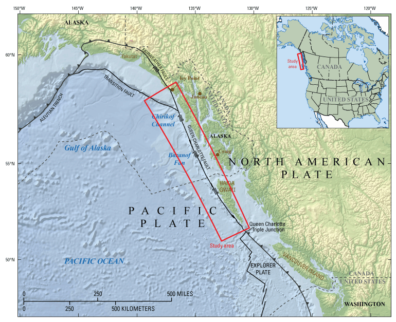
Map showing the Queen Charlotte-Fairweather fault system in southeastern Alaska and western British Columbia. Figure is replicated from the sheets of this report for the reader’s convenience; the figure has been designed for optimal viewing in the sheets at https://doi.org/10.3133/ofr20221085.
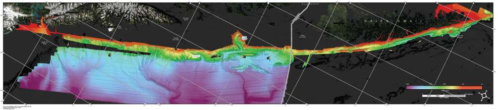
A bathymetric terrain model (fig. 2) was compiled from six different multibeam surveys of the previously unmapped Queen Charlotte fault offshore of southeastern Alaska and Haida Gwaii archipelago. The multibeam survey data were collected between 2005 and 2018 under a cooperative agreement between the U.S. Geological Survey, Natural Resources Canada, the Alaska Department of Fish and Game, and the National Oceanic and Atmospheric Administration. The terrain model that was generated from the multibeam data is published as a 30-meter resolution georeferenced tagged image file format (GeoTIFF) in Andrews and others (2022).
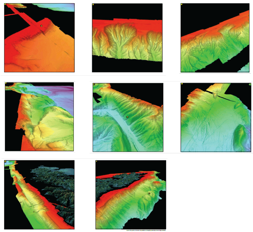
Three-dimensional (3D) perspective views of the Queen Charlotte fault system in southeastern Alaska and western British Columbia. A, Overview map rotated 62 degrees west from true north; the hillshaded bathymetry is vertically exaggerated three times. Azimuth is in degrees from true north. B–I, Perspective view of B, the fault as it crosses the Yakobi Sea Valley showing the approximately 900-meter (m) right lateral offset at map point “a” (center of 3D image: 397948.33 E, 6445333 N, azimuth 188); C, a previously unknown canyon head offset by the fault (center of 3D image: 388052 E, 6379748 N, azimuth 75); D, a canyon head west of Sitka, offset by the fault (center of 3D image: 409603 E, 6305930 N, azimuth 106); E, looking south along the fault with “mud hole” at map point “b” south of Sitka in the foreground (center of 3D image: 476484.0 E, 6205879 N, azimuth 164); F, looking north along the fault with offset gullies at map point “c” northwest of Noyes Canyon (center of 3D image: 526324 E, 6083885 N, azimuth 35); G, along the fault at the United States-Canada border (center of 3D image: 528542 E, 6051747 N, azimuth 130); H, along the fault of offset gullies at map point “d” and landslide scar at map point “e” offshore of Graham Island, Canada (center of 3D image: 657214 E, 5857969 N, azimuth 342); I, looking south at the transpressional stepovers and pop-up ridges at map point “f” off Moresby Island, Canada (center of 3D image: 691278 E, 5825029 N, azimuth 118).The coordinates in italics at the end of each figure caption define the center of each 3D image (yellow circles on overview map) based on the UTM 8N, WGS 84 coordinate system. Followed by the direction (azimuth) of the image in degrees (true) illustrated by yellow arrows in the overview map above. Location of study area shown on figure 1. Figure is replicated from the sheets of this report for the reader’s convenience; the figure has been designed for optimal viewing in the sheets at https://doi.org/10.3133/ofr20221085.
The seabed morphology is characterized by the following sets of features (fig. 3):
-
numerous submarine canyons, gullies, channels and fan aprons that have been offset by horizontal motion on the Queen Charlotte fault;
-
elongate pull-apart basins and pressure ridges associated with bends and jogs on the Queen Charlotte fault;
-
submarine landslides, scarps, scars, and mass transport deposits; and
-
broad sediment aprons located seaward of major shelf sea valleys (that is, trough-mouth fans) that expand across the continental slope and rise of the eastern Gulf of Alaska, delivering sediment to the Baranof Fan and Chirikof channel systems.
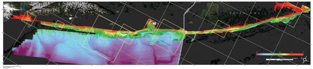
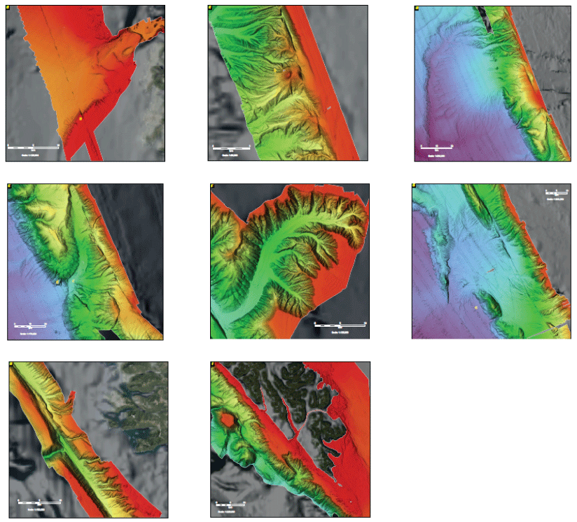
Two-dimensional (2D) perspective views of the Queen Charlotte fault system in southeastern Alaska and western British Columbia. A, Overview map rotated 62 degrees west from true north; the hillshaded bathymetry is vertically exaggerated three times. B, An approximately 900-meter (m) right-lateral offset at map point “a” along the southern margin of the Yakobi Sea Valley provides an estimate of cumulative fault movement since glacial ice receded from the valley; arcuate features at the mouth of Cross Sound are recessional moraines left behind as the ice sheet retreated into Icy Strait and Glacier Bay (Brothers and others, 2020). C, Incised gullies and canyons originating at the continental shelf-edge have been cut and translated by movement along the fault; a small volcanic cone at map point “b” is observed along the western edge of the fault (Prouty and others, 2020). D, Submarine canyons and slope gullies feed the Baranof fan and channel; during sea level lowstands, glacial sediments were transported through the Chatham Sea Valley and deposited onto the continental shelf-edge and slope (Brothers and others, 2019, 2020). E, Steep tectonically deformed topography along the lower slope is intersected by a submarine canyon, forming a knick-point at map point “c” and plunge pool at map point “d” by the erosive action of sediment flows. F, Noyes Canyon incises the continental shelf and takes a 90-degree northward turn as it meets the fault. G, Submarine fan lobes formed by sediment flows emanating from the Dixon Sea Valley during sea level lowstands; the fan surfaces have been offset by repeated movement along the fault (Brothers and others, 2020), and a series of steep elongate ridges at map point “e” have formed in response to tectonic deformation. H, Fault-parallel valleys to the west of Graham Island illustrate the influence of faulting on submarine canyon and gully evolution. I, Along-strike stepovers along the fault create complex deformation patterns and seafloor morphology seaward of Moresby Island; the fault steps around a series of knolls and ridges and cut across the mouth of Moresby Canyon. Location of study area shown on figure 1. Figure is replicated from the sheets of this report for the reader’s convenience; the figure has been designed for optimal viewing in the sheets at https://doi.org/10.3133/ofr20221085.
References Cited
Andrews, B.D., Brothers, D.S., Dartnell, P., and Barrie, J.V., 2022, A bathymetric terrain model of multibeam data collected between 2005 and 2018 along the Queen Charlotte fault system in the eastern Gulf of Alaska from Cross Sound, Alaska, to Queen Charlotte Sound, Canada: U.S. Geological Survey data release, https://doi.org/10.5066/P9YGDHIQ.
Brothers, D.S., Andrews, B.D., Walton, M.A.L., Greene, H.G., Barrie, J.V., Miller, N.C., ten Brink, U., East, A.E., Haeussler, P.J., Kluesner, J.W., and Conrad, J.E., 2019, Slope failure and mass transport processes along the Queen Charlotte fault, southeastern Alaska, in Lintern, D.G., Mosher, D.C., Moscardelli, L.G., Bobrowsky, P.T., Campbell, C., Chaytor, J., Clague, J., Georgiopoulou, A., Lajeunesse, P., Normandeau, A., Piper, D., Scherwath, M., Stacey, C., and Turmel, D., eds., Subaqueous mass movements and their consequences—Assessing geohazards, environmental implications and economic significance of subaqueous landslides: London, Geological Society Special Publications, v. 477, no. 1, p. 69–83, accessed June 8, 2022, at https://doi.org/10.1144/SP477.30.
Brothers, D.S., Miller, N.C., Barrie, J.V., Haeussler, P.J., Greene, H.G., Andrews, B.D., Zielke, O., Watt, J., and Dartnell, P., 2020, Plate boundary localization, slip-rates and rupture segmentation of the Queen Charlotte fault based on submarine tectonic geomorphology: Earth and Planetary Science Letters, v. 530, paper 115882, 16 p., accessed June 8, 2022, at https://doi.org/10.1016/j.epsl.2019.115882.
Lay, T., Ye, L., Kanamori, H., Yamazaki, Y., Cheung, K.F., Kwong, K., and Koper, K.D., 2013, The October 28, 2012 Mw 7.8 Haida Gwaii underthrusting earthquake and tsunami—Slip partitioning along the Queen Charlotte fault transpressional plate boundary: Earth and Planetary Science Letters, v. 375, p. 57–70, accessed June 8, 2022, at https://doi.org/10.1016/j.epsl.2013.05.005.
Prouty, N.G., Brothers, D.B., Kluesner, J.W., Barrie, J.V., Andrews, B.D., Lauer, R.M., Greene, H.G., Conrad, J.E., Lorenson, T.D., Law, M.D., Sahy, D., Conway, K.W., McGann, M.L., and Dartnell, P., 2020, Focused fluid flow and methane venting along the Queen Charlotte fault, offshore Alaska (USA) and British Columbia (Canada): Geosphere, v. 16, no. 6, p. 1336–1357, accessed June 8, 2022, at https://doi.org/10.1130/GES02269.1.
Tréhu, A.M., Scheidhauer, M., Rohr, K.M., Tikoff, B., Walton, M.A., Gulick, S.P., and Roland, E.C., 2015, An abrupt transition in the mechanical response of the upper crust to transpression along the Queen Charlotte fault: Bulletin of the Seismological Society of America, v. 105, no. 2B, p. 1114–1128, accessed September 30, 2022, at https://doi.org/10.1785/0120140159.
Yue, H., Lay, T., Freymueller, J.T., Ding, K., Rivera, L., Ruppert, N.A., and Koper, K.D., 2013, Supershear rupture of the 5 January 2013 Craig, Alaska (MW 7.5) earthquake: Journal of Geophysical Research: Solid Earth, v. 118, no. 11, p. 5903–5919, accessed September 30, 2022, at https://doi.org/10.1002/2013JB010594.
Suggested Citation
Andrews, B.D., Brothers, D.S., Dartnell, P., Barrie, J.V., Haeussler, P.J., Green, K.M., Greene, H.G., Miller, N.C., Kluesner, J.W., and ten Brink, U.S., 2022, Systematic mapping of the ocean-continent transform plate boundary of the Queen Charlotte fault system, southeastern Alaska and western British Columbia—A preliminary bathymetric terrain model: U.S. Geological Survey Open-File Report 2022–1085, 2 sheets, 7-p. pamphlet, https://doi.org/10.3133/ofr20221085.
ISSN: 2331-1258 (online)
Study Area
| Publication type | Report |
|---|---|
| Publication Subtype | USGS Numbered Series |
| Title | Systematic mapping of the ocean-continent transform plate boundary of the Queen Charlotte fault system, southeastern Alaska and western British Columbia—A preliminary bathymetric terrain model |
| Series title | Open-File Report |
| Series number | 2022-1085 |
| DOI | 10.3133/ofr20221085 |
| Year Published | 2022 |
| Language | English |
| Publisher | U.S. Geological Survey |
| Publisher location | Reston, VA |
| Contributing office(s) | Woods Hole Coastal and Marine Science Center |
| Description | Pamphlet: iii, 7 p.; 2 Sheets: 60.50 × 42.50 inches and 60.00 × 42.00 inches; Data Release |
| Country | Canada, United States |
| State | Alaska, British Columbia |
| Other Geospatial | Queen Charlotte Fault |
| Online Only (Y/N) | Y |
| Additional Online Files (Y/N) | N |
| Google Analytic Metrics | Metrics page |