

Hydrologic Data for Water-Management Plans—A Resource for Tribal Governments in Oklahoma
Links
- Document: Report (5.43 MB pdf) , HTML , XML
- Download citation as: RIS | Dublin Core
Introduction
The major streams in Oklahoma, and the alluvial aquifers associated with those major streams, are important resources for the 39 federally recognized Tribes in Oklahoma (figs. 1 and 2). Many Tribal Governments are interested in developing water-management plans (hereinafter referred to as “water plans”) to preserve water resources for the future. This report provides a general overview of the types of information and data needed to prepare comprehensive water plans. To assist Tribes in the development of water plans, the U.S. Geological Survey (USGS), in cooperation with the Bureau of Indian Affairs, has outlined the steps necessary for creation of such plans.
Steps to Develop a Water-Management Plan
1. Compile and characterize existing water-resources data.
2. Establish priorities for water resources (determined by the Tribal Government).
3. Identify data gaps and develop a process to reach water-management plan goals by filling those gaps.
4. Identify problems or concerns related to quantity, quality, or availability of water.
5. Set future management goals and strategies.
What is a Water Plan?
A water plan describes the water resources available to Tribal Governments and how those resources might best be used to serve Tribes in Oklahoma. Water plans typically include priorities established by Tribal Governments to help inform water-management decisions. Here are some examples of the concerns that water plans for Tribal Governments often address:
-
Water sustainability and conservation,
-
Wildlife and habitat conservation,
-
Agricultural management,
-
Water uses,
-
Resource planning, and
-
Community and economic planning.
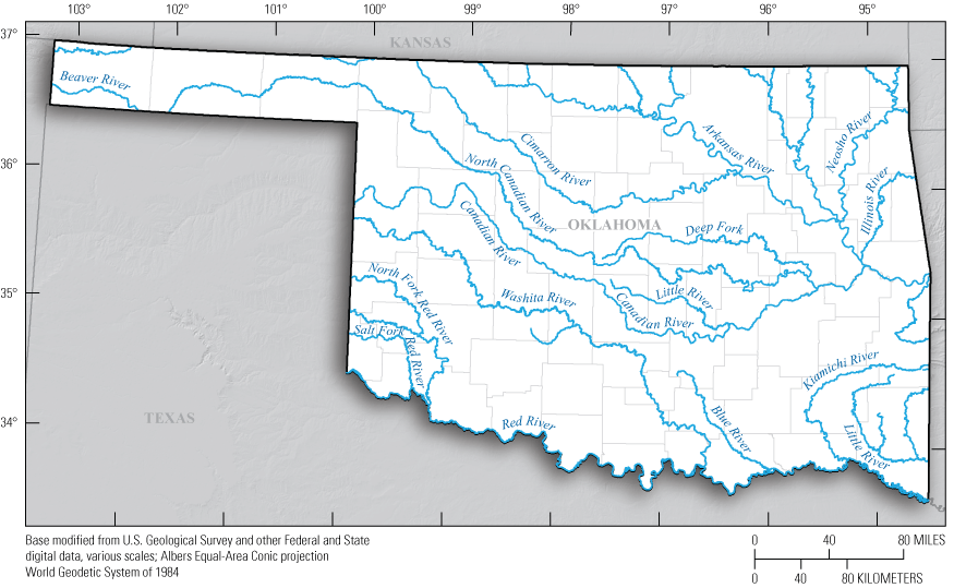
The major streams in Oklahoma.
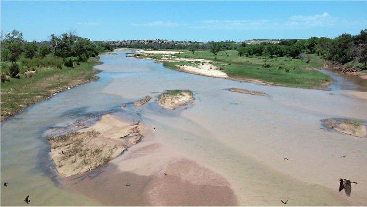
The Salt Fork Red River. Photograph by C. Becker, U.S. Geological Survey, June 2015.
Compile and Characterize Existing Water-Resources Data
By first compiling hydrologic data to characterize the quantity and quality of their water resources, a Tribal Government will be able to best decide how to manage those resources. The following are some of the primary online sources of hydrologic data in Oklahoma.
-
USGS National Water Information System database: https://doi.org/10.5066/F7P55KJN.
-
USGS groundwater data for Oklahoma: https://waterdata.usgs.gov/ok/nwis/gw.
-
USGS spring discharge data for Oklahoma: https://waterdata.usgs.gov/ok/nwis/inventory?site_tp_cd=SP&format=station_list&group_key=county_cd&list_of_search_criteria=site_tp_cd.
-
USGS water-quality data for Oklahoma: https://waterdata.usgs.gov/ok/nwis/qw.
-
USGS streamflow data for Oklahoma: https://waterdata.usgs.gov/ok/nwis/rt.
-
USGS Streamstats, a map-based web application that provides analytical data and tools for water-resources planning and management: https://streamstats.usgs.gov.
-
Oklahoma Water Resources Board (OWRB) streamflow data: https://www.arcgis.com/apps/webappviewer/index.html?id=f1656b4620f44fdd8c08e95192f75c46.
-
U.S. Army Corps of Engineers reservoir storage and release data: https://www.swt-wc.usace.army.mil/.
-
Bureau of Reclamation reservoir data: https://www.usbr.gov/gp/lakes_reservoirs/oklahoma_lakes.html.
-
Grand River Dam Authority River Operations Report: https://stormops.grda.tech/riveroperations.
-
National Inventory of Dams: https://nid.usace.army.mil/#/.
Descriptions of common types of groundwater, surface-water, and water-quality data are as follows.
Groundwater Levels—The term “groundwater level” refers to the depth from the land surface to the top of the water table; groundwater-level altitudes are calculated by subtracting the groundwater-level measurement from the land-surface altitude at the well referenced to a datum such as the North American Vertical Datum of 1988 (Cunningham and Schalk, 2011). Groundwater levels can be used to help assess the amount of groundwater in storage and general flow directions in an aquifer system. A typical continuous groundwater-level monitoring well in Oklahoma can be seen in figure 3.
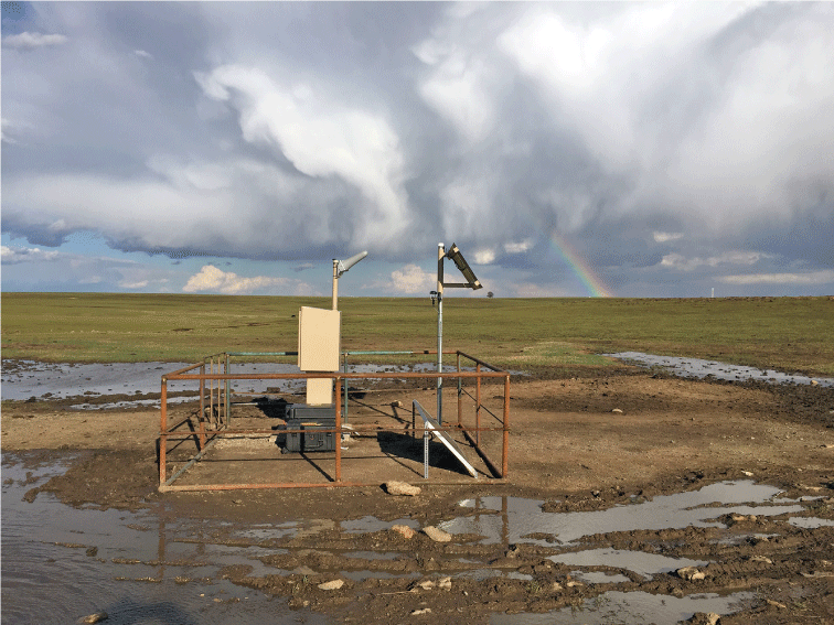
A groundwater-level monitoring well in Osage County, Oklahoma. Photograph by the U.S. Geological Survey, April 2017.
Groundwater levels in alluvial aquifer systems are usually less than those in bedrock aquifer systems because alluvial aquifer systems are contained in relatively shallow alluvial deposits (Hoekstra and others, 2011). Groundwater levels in bedrock aquifer systems can vary considerably and can be shallow or deep depending on the extent and consolidated nature of the rock.
Groundwater levels in Oklahoma (OWRB, 2021b) can be affected by seasonal fluctuations in the water budget, nearby persistent groundwater use, precipitation, and direct recharge from streams or surface inflow to the aquifer (Alley and others, 1999). Groundwater levels measured over time provide insights into how groundwater availability may fluctuate in a particular area. Groundwater generally flows from high head (higher altitude) to low head (lower altitude), and the general groundwater-flow direction can be interpreted from synoptic groundwater-level measurements in multiple wells completed in the same aquifer. Springflow discharging from the Arbuckle-Simpson aquifer is the source of water to Turner Falls, seen in figure 4.
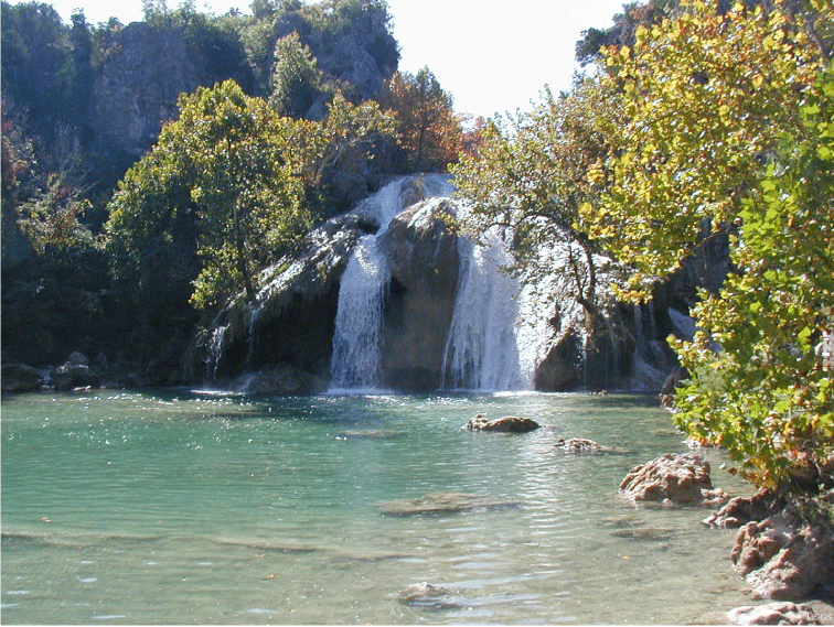
Turner Falls, the largest waterfall in Oklahoma, near Davis, Oklahoma. Springs discharging from the Arbuckle-Simpson aquifer into Honey Creek are the source of water to Turner Falls. Photograph by the U.S. Geological Survey.
Aquifer Characteristics—Aquifer thickness and storage properties, along with groundwater levels, can be used to assess groundwater storage. The amount of groundwater available in aquifers is calculated through measurements of groundwater levels and numerical groundwater-flow models. This information can be used to determine how water-usage patterns will affect groundwater availability in the aquifer in the future (Winter and others, 1998). The two types of aquifer systems in Oklahoma are bedrock and alluvial. Bedrock aquifers are composed of consolidated material such as limestone, dolomite, sandstone, siltstone, shale, or fractured crystalline rock (Hinaman, 2005). Alluvial aquifers are made up of unconsolidated stream sediments that typically allow water to move much faster than water can move in most bedrock aquifers. Characterizing the type of aquifer in a particular area can improve the understanding of groundwater storage and groundwater availability.
Streamflow—Historical and existing streamflow data (Ries and others, 2017; OWRB, 2021a; USGS, 2021) for streams in the jurisdictional areas of Tribal Governments and surrounding hydrologic drainage areas (watersheds) are often considered when creating a water plan. These data are usually collected in collaboration with Federal and State agencies. A typical real-time streamgage in northeastern Oklahoma can be seen in figure 5.
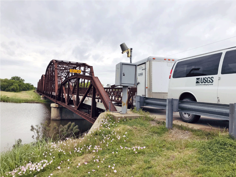
U.S. Geological Survey streamgage 07240200 on the North Canadian River at Highway 66 at Oklahoma City, Oklahoma. Photograph by T. Tibbets, U.S. Geological Survey, May 2020.
Reservoir Storage—Most reservoirs in Oklahoma were either constructed or are currently managed by the Bureau of Reclamation, the U.S. Army Corps of Engineers, or the Grand River Dam Authority. Additional reservoirs are owned and operated by various State and Federal agencies, cities, and other entities (Johnson, 2021). Reservoir storage and release data for many reservoirs are accessible from the reservoir and dam websites previously listed.
Springs—Springs are discharge points where groundwater flows onto the land surface. Springs can be ephemeral or perennial, depending on changes in groundwater levels and groundwater flow, and the amount a spring discharges can change over time as a result of changes in the groundwater budget. Measurements of spring discharge throughout the year can provide insights into how the groundwater budget changes as a result of variations in seasonal groundwater discharge to streams and reservoirs.
Water Quality—Data that describe the quality of water are important in determining the ways that the water can be used. To be considered potable, treated drinking water needs to meet the National Primary Drinking Water Regulations for constituent concentrations developed by the U.S. Environmental Protection Agency (2009). Water used for irrigation can be non-potable (National Blue Ribbon Commission for Onsite Non-Potable Water Systems, 2017). Monitoring the quality of the water resources during runoff events can provide insights into the relation between land use and water quality. For example, runoff from urban or agricultural land uses can lead to excess amounts of nutrients, such as phosphorous and nitrogen, entering the water (Paizis and Trevisan, 2021).
Denitrification is a natural process that occurs in aquifers to reduce nitrate and nitrite concentrations in groundwater through microbial processes to produce gaseous forms of nitrogen (Blicher-Mathiesen and others, 1998). Nitrogen exists naturally in the environment but is also introduced into groundwater resources through nitrates in runoff from fertilized land and livestock farms, atmospheric nitrates from combustion of fossil fuels in rainwater, residual nitrogen in sewage effluent, and natural oxidation processes (USGS, 1999). The gaseous forms of nitrogen are released from the aquifer in the form of nitrogen gas bubbles, as seen in figure 6 (Christenson and others, 2009). In figure 6, denitrification can be seen taking place in the Arbuckle-Simpson aquifer.
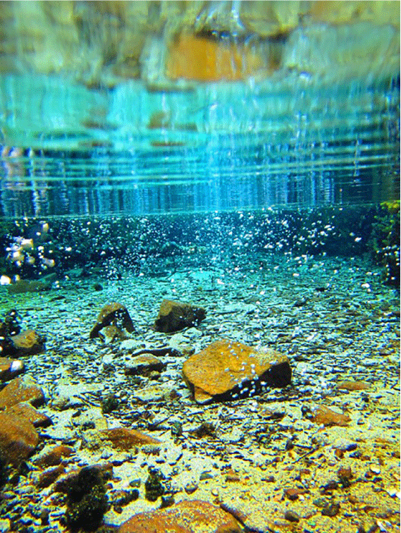
A spring discharging from the Arbuckle-Simpson aquifer. The bubbles are indicative of denitrification. Photograph by C. Becker, U.S. Geological Survey, March 2019.
Water Budget—A water budget accounts for the inflows and outflows of surface water and groundwater in each watershed during a specified period. A water budget is prepared from a collection of hydrologic data consisting of sources of water, water use, and land use that will be used to evaluate the spatial distribution of water on Tribal lands. Calculation of a water budget for a water resource or specific area can inform Tribes on the amount of water available for use. Water budgets can be prepared for surface water, groundwater, or both by using real-time and long-term collected hydrologic data. Streamflow data can be used to assess the surface-water budget (the balance of stream inflows minus outflows on an annual mean basis). The surface-water budget can provide an estimate of the average amount of surface water flowing through a given Tribal jurisdictional area and changes in streamflow volumes over time. This type of assessment is normally done by using data obtained at continuous streamgages. Groundwater-flow models are typically used to assess groundwater budgets and can be used to assess changes to overlying streamflow and reservoir budgets; see Ellis (2018) and Smith and others (2021) for examples. Water budgets can change over time and are affected by changes in precipitation, water use, and land use. Once a water budget is calculated for a given period, projected future variability in the water budget caused by changes in precipitation, water use, or land use can be estimated. The results of projected future analyses of water budgets can facilitate the development of water plans by Tribal Governments.
Land Use—Land-use type can directly or indirectly affect surface- and groundwater quality and groundwater recharge. For example, the effects of urban, agricultural, and recreational land uses on water resources are appreciable and different. Urbanization and agriculture can affect soil porosity, which is the amount of space available between soil particles, altering the direction of runoff and affecting recharge rates (Reilly and others, 2008). Quarries and other mining activities can also alter the direction of runoff, affect recharge rates, and introduce contaminants to the surface water and groundwater (Langer, 2001). Extensive groundwater withdrawals to supply urban areas or to be used for agricultural practices or irrigation can cause groundwater levels to decrease appreciably, resulting in decreased water availability and impaired water quality (Bartolino and Cunningham, 2003).
Habitat—Streams and lakes and the riparian vegetation provide habitat for aquatic and terrestrial species. Riparian habitats can be negatively affected by degraded water quality and a loss of general riparian health, including habitat fragmentation. For example, land-use changes such as the removal of tree canopies along streams can degrade and fragment stream habitats (Yirigui and others, 2019). Riparian vegetation can also die or become unhealthy if base flows are diminished by excessive groundwater withdrawals, resulting in stream erosion and sedimentation issues (Stromberg and others, 1996). Without sufficient inflows of groundwater to sustain base flows, the water quality can become impaired. Biodiversity is dependent on abundant habitat and water availability and is affected by a loss in riparian health and degraded water quality (Montgomery, 1996). A healthy aquatic environment will sustain sensitive benthic invertebrate species referred to as water-quality indicator species; a loss of indicator species might mean the water quality has been impaired (Chambers and Messinger, 2001).
Establish Priorities and Identify and Fill Data Gaps
Once water resources have been quantified and described, and priorities have been established by the Tribe, then gaps in datasets can be identified and plans can be made to help fill those gaps. Water plans can incorporate planning steps and strategies to fill data gaps. Examples include planning to add a streamgage or make a series of streamflow measurements at a stream site that is crucial for quantifying outflow from a Tribal jurisdictional area. Additionally, groundwater monitoring equipment could be deployed at a network of wells to better understand groundwater resources and availability. Tribes with water-quality concerns could initiate water-quality sampling for nutrients such as nitrogen and phosphorus or heavy metals such as arsenic. If the concentrations of these constituents are elevated, drinking water viability, riparian habitats, and other water-resource concerns can be affected. Land use could also be evaluated to determine areas of excessive runoff. In these areas, the installation of storm retention ponds and green infrastructure (U.S. Environmental Protection Agency, 2015), such as rain barrels or green roofs where vegetation is planted over a waterproof layer, could be implemented to attenuate stormwater runoff and encourage sustainable water use.
Identify Problems or Concerns Related to Quantity, Quality, or Use of Water
Once water-resource priorities have been established and data have been collected, Tribal Governments are better enabled to identify potential problems or concerns regarding water resources. Continuously collected water-resources data can be used to discern trends in the data that could indicate problems. Possible problems or areas of concern could include aquifer depletion from overuse, decreased water quality caused by agricultural runoff and nutrient leaching, and habitat degradation. Numerous competing priorities for water resources make it challenging to balance sustainability with use.
Potential Problems and Concerns
The goal of developing an effective water plan is to ensure an adequate water supply is maintained while also considering the quality of the water and the environment. A water plan can be used to help balance the demands for surface water and groundwater by taking the sustainability of the overall water resources into account. Water resources can be negatively affected by many water-management strategies, such as out-of-basin transfers, stream diversions, and groundwater withdrawals. Water and habitat quality can be affected by excess nutrients and other chemicals from agricultural sources, such as poultry farming. Contaminants can also be introduced into the surface water or groundwater from industrial sources, such as quarries and mineral exploration activities (Langer, 2001) The following water-resource concerns are typically considered when developing a water plan:
• Adequacy of the water supply;
• Effects of basin transfers, stream diversions, and groundwater withdrawals on supply and the environment;
• Quality of water resources;
• Safety of the drinking water from domestic wells;
• Effects of agricultural activities on water quality (nutrients, antibiotics, or arsenic);
• Effects of quarries on the water budget, water quality, and habitats;
• Effects of mineral exploration activities on water resources and the environment (water quality, water supply, erosion, and habitat fragmentation);
• Effects of groundwater withdrawals on streams and springs;
• Maintenance of the environmental streamflows needed for healthy habitats where aquatic species such as fish and freshwater mussels can thrive, and maintenance of streamflows needed to support recreation and domestic use;
• Optimization of surface-water and groundwater withdrawals while also protecting the environment and water resources; and
• Inclusion of plans for response to floods, droughts, and wildfires.
Set Future Management Goals and Strategies
Effective long-term management strategies are designed to preserve the water resources for Tribal communities through adaptable water plans that can readily account for changes in land use and other types of landscape modification over time. Understanding the current water-resource uses and how they are changing is dependent on the availability of ongoing hydrologic data monitoring, including the collection of continuous (real-time) hydrologic data. Collecting different types of surface-water and groundwater data, as well as water-use and land-use data, can help to close data gaps in water plans and ensure the preservation of important water resources for the Tribes in Oklahoma.
Summary
Reliable long-term hydrologic data, real-time measurements, and modeling (surface water, groundwater, and water quality) are essential in developing comprehensive water-management plans for current and future water-resource needs of the 39 federally recognized Tribes in Oklahoma. To assist Tribes in the development of water-management plans, the U.S. Geological Survey, in cooperation with with Bureau of Indian Affairs, has outlined the steps necessary for creation of such plans. The first step in developing a water-management plan is compiling and characterizing existing water-resources data, available from the U.S. Geological Survey and other agencies, to understand the availability and quality of surface water and groundwater. Establishing water-resources priorities is the next step, followed by identification of data gaps that need to be filled. Next, concerns related to quantity, quality, or availability of water can be identified so that the final step, setting future management goals and strategies, can be accomplished.
References Cited
Alley, W.M., Reilly, T.E., and Franke, O.L., 1999, Sustainability of ground-water resources: U.S. Geological Survey Circular 1186, 76 p., accessed January 11, 2022, at https://doi.org/10.3133/cir1186.
Bartolino, J.R., and Cunningham, W.L., 2003, Ground-water depletion across the Nation: U.S. Geological Survey Fact Sheet 103–03, 4 p., accessed January 19, 2022, at https://doi.org/10.3133/fs10303.
Blicher-Mathiesen, G., McCarty, G.W., and Nielsen, L.P., 1998, Denitrification and degassing in groundwater estimated from dissolved dinitrogen and argon: Journal of Hydrology, v. 208, no. 1–2, p. 16–24, accessed May 25, 2022, at https://doi.org/10.1016/S0022-1694(98)00142-5.
Chambers, D.B., and Messinger, T., 2001, Benthic invertebrate communities and their responses to selected environmental factors in the Kanawha River Basin, West Virginia, Virginia, and North Carolina: U.S. Geological Survey Water-Resources Investigations Report 01–4021, 52 p., accessed January 11, 2022, at https://doi.org/10.3133/wri014021.
Christenson, S., Hunt, A.G., and Parkhurst, D.L., 2009, Geochemical investigation of the Arbuckle-Simpson aquifer, south-central Oklahoma, 2004–06: U.S. Geological Survey Scientific Investigations Report 2009–5036, 50 p., accessed February 14, 2022, at https://doi.org/10.3133/sir20095036.
Cunningham, W.L., and Schalk, C.W., comps., 2011, Groundwater technical procedures of the U.S. Geological Survey: U.S. Geological Survey Techniques and Methods 1–A1, 151 p., accessed January 7, 2022, at https://doi.org/10.3133/tm1A1.
Ellis, J.H., 2018, Simulation of groundwater flow and analysis of projected water use for the Rush Springs aquifer, western Oklahoma: U.S. Geological Survey Scientific Investigations Report 2018–5136, 156 p., accessed October 20, 2021, at https://doi.org/10.3133/sir20185136.
Hinaman, K., 2005, Hydrogeologic framework and estimates of ground-water volumes in Tertiary and Upper Cretaceous hydrogeologic units in the Powder River Basin, Wyoming: U.S. Geological Survey Scientific Investigations Report 2005–5008, 17 p., accessed August 17, 2021, at https://doi.org/10.3133/sir20055008.
Hoekstra, A.Y., Chapagain, A.K., Aldaya, M.M., and Mekonnen, M.M., 2011, The water footprint assessment manual—Setting the global standard: London, Earthscan, 203 p., accessed August 13, 2021, at https://waterfootprint.org/media/downloads/TheWaterFootprintAssessmentManual_2.pdf.
Johnson, K.S., 2021, Lakes and reservoirs, in The encyclopedia of Oklahoma history and culture: Oklahoma Historical Society, accessed May 5, 2022, at https://www.okhistory.org/publications/enc/entry?entry=LA010.
Langer, W.H., 2001, Potential environmental impacts of quarrying stone in karst—A literature review: U.S. Geological Survey Open-File Report 2001–484, 39 p., accessed January 19, 2022, at https://doi.org/10.3133/ofr01484.
Montgomery, G.L., 1996, Riparian areas reservoirs of diversity: U.S. Department of Agriculture, Natural Resources Conservation Service, Working Paper No. 13, accessed January 18, 2022, at https://www.nrcs.usda.gov/wps/portal/nrcs/detail/wy/home/?cid=nrcs143_014206.
National Blue Ribbon Commission for Onsite Non-Potable Water Systems, 2017, A guidebook for developing and implementing regulations for onsite non-potable water systems, accessed September 17, 2021, at http://uswateralliance.org/resources/publications.
Oklahoma Water Resources Board [OWRB], 2021a, Lake level and streamflow conditions for Oklahoma, accessed September 17, 2021, at https://www.arcgis.com/apps/webappviewer/index.html?id=f1656b4620f44fdd8c08e95192f75c46.
Oklahoma Water Resources Board [OWRB], 2021b, Groundwater studies—North Canadian River alluvial aquifer, accessed September 2, 2021, at https://www.owrb.ok.gov/studies/groundwater/northcanadian.php.
Paizis, N.C., and Trevisan, A.R., 2021, Cimarron River alluvial aquifer hydrogeologic framework, water budget, and implications for future water availability in the Pawnee Nation Tribal jurisdictional area, Payne County, Oklahoma, 2016–18: U.S. Geological Survey Scientific Investigations Report 2021–5073, 49 p., accessed May 5, 2022, at https://doi.org/10.3133/sir20215073.
Reilly, T.E., Dennehy, K.F., Alley, W.M., and Cunningham, W.L., 2008, Ground-water availability in the United States: U.S. Geological Survey Circular 1323, 70 p., accessed January 3, 2022, at https://doi.org/10.3133/cir1323.
Ries, K.G., III, Newson, J.K., Smith, M.J., Guthrie, J.D., Steeves, P.A., Haluska, T.L., Kolb, K.R., Thompson, R.F., Santoro, R.D., and Vraga, H.W., 2017, StreamStats, version 4: U.S. Geological Survey Fact Sheet 2017–3046, 4 p., accessed January 11, 2022, at https://doi.org/10.3133/fs20173046.
Smith, S.J., Ellis, J.H., Paizis, N.C., Becker, C.J., Wagner, D.L., Correll, J.S., and Hernandez, R.J., 2021, Hydrogeology and model-simulated groundwater availability in the Salt Fork Red River aquifer, southwestern Oklahoma, 1980–2015: U.S. Geological Survey Scientific Investigations Report 2021–5003, 85 p., accessed January 3, 2022, at https://doi.org/10.3133/sir20215003.
Stromberg, J.C., Tiller, R., and Richter, B., 1996, Effects of groundwater decline on riparian vegetation of semiarid regions—The San Pedro, Arizona: Ecological Applications, v. 6, no. 1, p. 113–131, accessed January 11, 2022, at https://doi.org/10.2307/2269558.
U.S. Environmental Protection Agency, 2009, National Primary Drinking Water Regulations: U.S. Environmental Protection Agency, EPA 816-F-09-004, 6 p., accessed January 3, 2022, at https://www.nrc.gov/docs/ML1307/ML13078A040.pdf.
U.S. Environmental Protection Agency, 2015, Green infrastructure opportunities that arise during municipal operations: U.S. Environmental Protection Agency, Office of Wetlands, Oceans and Watersheds, National Estuary Program, EPA 842-R-15-002, 36 p., accessed January 18, 2022, at https://www.epa.gov/sites/default/files/2015-09/documents/green_infrastructure_roadshow.pdf.
U.S. Geological Survey [USGS], 1999, The quality of our nation’s waters nutrients and pesticides: U.S. Geological Survey Circular 1225, 82 p., accessed May 26, 2022, at https://doi.org/10.3133/cir1225.
U.S. Geological Survey [USGS], 2021, USGS water data for the Nation: U.S. Geological Survey National Water Information System database, accessed January 10, 2022, at https://doi.org/10.5066/F7P55KJN.
Winter, T.C., Harvey, J.W., Franke, O.L., and Alley, W.M., 1998, Ground water and surface water—A single resource: U.S. Geological Survey Circular 1139, 79 p., accessed January 11, 2022, at https://doi.org/10.3133/cir1139.
Yirigui, Y., Lee, S.-W., Nejadhashemi, A.P., Herman, M.R., and Lee, J.-W., 2019, Relationships between riparian forest fragmentation and biological indicators of streams: Sustainability, v. 11, no. 10, article 2870, accessed January 11, 2022, at https://doi.org/10.3390/su11102870.
For more information about this publication, contact
Director, Oklahoma-Texas Water Science Center
U.S. Geological Survey
1505 Ferguson Lane
Austin, TX 78754-4501
Suggested Citation
Higginbotham, M., and Mashburn, S.L., 2022, Hydrologic data for water-management plans—A resource for Tribal Governments in Oklahoma: U.S. Geological Survey Circular 1498, 10 p., https://doi.org/10.3133/cir1498.
ISSN: 2330-5703 (online)
Study Area
| Publication type | Report |
|---|---|
| Publication Subtype | USGS Numbered Series |
| Title | Hydrologic data for water-management plans—A resource for Tribal Governments in Oklahoma |
| Series title | Circular |
| Series number | 1498 |
| DOI | 10.3133/cir1498 |
| Year Published | 2022 |
| Language | English |
| Publisher | U.S. Geological Survey |
| Publisher location | Reston, VA |
| Contributing office(s) | Oklahoma-Texas Water Science Center |
| Description | iii, 10 p. |
| Country | United States |
| State | Oklahoma |
| Online Only (Y/N) | Y |
| Google Analytic Metrics | Metrics page |