

Maine and Landsat
Links
- Document: Report (4.62 MB pdf) , HTML , XML
- Version History: Version History (1 kB txt)
- Download citation as: RIS | Dublin Core
Abstract
As the Nation’s northeastern-most State, Maine’s reputation is that of rocky coastlines, rich maritime history symbolized by lighthouses dotting the ocean bluffs, and wondrous nature areas like the granite and spruce islands of Acadia National Park.
But Maine is a place of changes too. The State has warmed about 3 degrees Fahrenheit in the last 120 years. Spring is arriving earlier, bringing more precipitation. Heavy rainstorms are more frequent, and summers are hotter and drier. With sea levels rising, severe storms increasingly cause floods that damage property and infrastructure.
In the coming decades, as the changing climate continues to increase flooding, harm ecosystems, and disrupt fishing and agriculture, here are four critical areas where Landsat satellite systems can be valuable tools in monitoring those changes and their effects, on the land and in the water.
Forest Health and Changes
With 89 percent of its territory classified as forest, Maine is the most forested State in the Nation. The forest industry is a driving force in the State’s economy and has an annual economic impact of $8.5 billion. Landsat time-series imagery provides a valuable asset to the forestry industry. When used with county-level Forest Inventory and Analysis estimates, Landsat data enable decision makers to gather a variety of information: analyze forest distribution; identify forest cover loss through harvests, fire, disease, or other disturbance; and identify forest gain through regeneration (Sader and others, 2005).
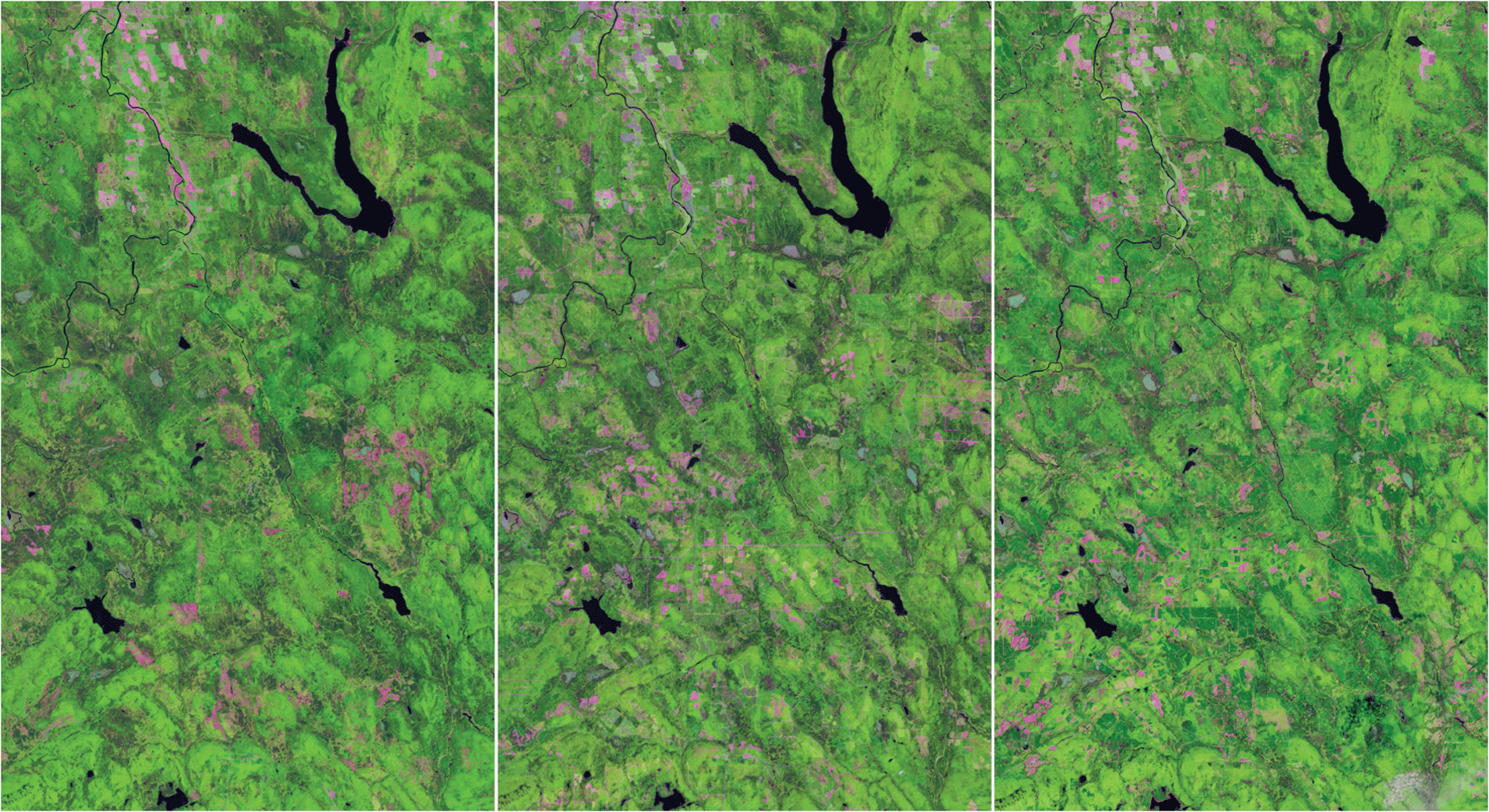
These three Landsat images, from the summers of (left to right) 1985, 2002, and 2019, show areas in northeastern Maine where forest clearcuts are occurring over time. The pink areas in the upper center and upper right are from agriculture. The green in all three images is forest. Throughout the lower and center part of the images, areas of pink are where forests have been cleared. Image credit: U.S. Geological Survey.
Fishing and Farms
Researchers from the University of Maine have demonstrated that Landsat 8 data are useful in aquaculture site selection. Each summer, the State closes areas of coastline to shellfish harvesting because of harmful algal blooms. Analyzing validated Landsat temperature and water-quality fields enables the siting of promising oyster aquaculture areas out of harm’s way (Snyder and others, 2017). Landsat surface reflectance data can also help to differentiate between nutrient deficiencies and insect/weed problems in farm fields. Site-specific farming using Landsat can increase income and resolve environmental issues, thus easing agricultural management decisions (Leslie and others, 2017).
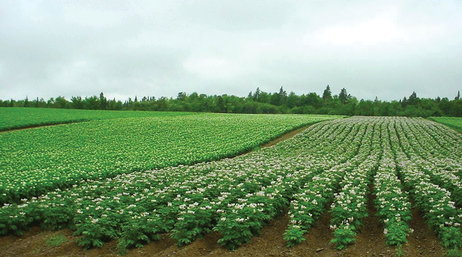
In Maine, where potatoes are an important crop, Landsat surface reflectance data can help to differentiate between nutrient deficiencies and insect/weed problems in farm fields. Photograph credit: Maine. gov; used with permission.
Coastlines and Wetlands
Rising sea levels erode Maine’s wetlands and beaches and increase damage from coastal storms. Geographers and remote-sensing scientists use Landsat to help map shorelines and inform decision makers on several areas: where human activities, such as filling tidal wetlands, not only affect habitat for bird and fish species but also remove an important line of defense against coastal flooding; where storm surges are becoming higher, eroding shorelines, and making coastal cities more vulnerable to storms; and where community infrastructure, such as highways, rail lines, wastewater treatment plants, and more, are threatened by sea-level rise and future storm surges (Pearsall, 2021).

Landsat imagery is used to help identify coastal areas vulnerable to storm surges and erosion. Photograph credit: Maine.gov; used with permission.
National Land Imaging Program Benefits—Maine
The U.S. Geological Survey (USGS) National Land Imaging Program provides a wide range of satellite imagery and other remotely sensed and geospatial data to Government, commercial, academic, and public users. Those users can get worldwide access to Landsat satellite data through the National Land Imaging Program-funded USGS Earth Resources Observation and Science (EROS) Center.
Landsat—Critical Information Infrastructure for the Nation
Landsat is the most widely used land remote sensing data source within Federal civilian agencies. Local, State, Tribal, and Federal agencies use Landsat to monitor and forecast a wide range of land surface phenomena. Information from Landsat contributes to day-to-day decisions on land, water, and resource use that protect life and property; safeguard the environment; advance science, technology, and education; support climate change resiliency; and grow the U.S. economy. Landsat’s imagery provides a landscape-level view of land surface, inland lake, and coastal processes, both natural and human-induced. Landsat enables us to better understand the scope, nature, and speed of change to the natural and built environment.
Businesses draw upon Landsat data to provide customer-specific applications to improve logistics, resource allocation, and investment decisions. Commercial space imaging firms leverage Landsat data to refine product offerings and support new information services. A 2017 USGS study determined the total annual economic benefit of Landsat data in the United States. to be $2.06 billion, far surpassing its development and operating costs (Straub and others, 2019).
Landsat 8 and Landsat 9 provide 8-day repeat coverage of the Earth’s land surfaces. The National Aeronautics and Space Administration (NASA) and the USGS are currently reviewing the findings from a joint Architecture Study Team, which will inform the design and implementation approach for Landsat Next, the follow-on mission to Landsat 9. Landsat 9 and its successors are planned to provide a sustainable, space-based system to extend the 50-year Landsat series of high-quality global land imaging measurements—the world’s longest time series of the Earth’s land surface.
The long-term availability of consistent and accurate Landsat data, combined with a no-cost data policy, allows users to analyze extensive geographic areas and better understand and manage long-term trends in land surface change. New cloud computing and data analytics technologies use Landsat data in a wide range of decision-support tools for Government and industry. Much like global positioning systems and weather data, Landsat data are used every day to help us better understand our dynamic planet.
References Cited
Leslie, C.R., Serbina, L.O., and Miller, H.M., 2017, Landsat and agriculture—Case studies on the uses and benefits of Landsat imagery in agricultural monitoring and production: U.S. Geological Survey Open-File Report 2017–1034, 27 p., accessed June 8, 2022, at https://doi.org/10.3133/ofr20171034.
Pearsall, P., 2021, Eyes in the sky—How satellite imagery transforms shoreline monitoring from “data-poor” to “data-rich”: U.S. Geological Survey web page, accessed May 11, 2023, at https://www.usgs.gov/centers/pcmsc/news/eyes-sky-how-satellite-imagery-transforms-shoreline-monitoring-data-poor-data.
Sader, S., Hoppus, M., Metzler, J., and Jin, S., 2005, Perspectives of Maine forest cover change from Landsat imagery and Forest Inventory Analysis (FIA): Journal of Forestry, v. 103, no. 6, p. 299–303, accessed June 2, 2022, https://www.fs.fed.us/ne/newtown_square/publications/other_publishers/OCR/ne_2005_sader001.pdf.
Snyder, J., Boss, E., Weatherbee, R., Thomas, A.C., Brady, D., and Newell, C., 2017, Oyster aquaculture site selection using Landsat 8-derived sea surface temperature, turbidity, and chlorophyll a: Frontiers in Marine Science, v. 4, art. 190, 11 p., accessed June 2, 2022, at http://misclab.umeoce.maine.edu/documents/Snyderetal2017.pdf.
Straub, C.L., Koontz, S.R., and Loomis, J.B., 2019, Economic valuation of Landsat imagery: U.S. Geological Survey Open-File Report 2019–1112, 13 p., accessed January 13, 2022, at https://doi.org/10.3133/ofr20191112.
For additional information on Landsat, please contact:
Program Coordinator
USGS National Land Imaging Program
12201 Sunrise Valley Drive
Reston, VA 20192
703–648–4567
The Landsat series is a joint effort of USGS and NASA. NASA develops and launches the spacecraft; USGS manages satellite operations, ground reception, data archiving, product generation, and data distribution. Funding for the National Land Imaging Program’s Landsat operations and data management is provided through the USGS.
Suggested Citation
U.S. Geological Survey, 2020, Maine and Landsat (ver. 1.2, May 2023): U.S. Geological Survey Fact Sheet 2020–3066, 2 p., https://doi.org/10.3133/fs20203066.
ISSN: 2327-6932 (online)
ISSN: 2327-6916 (print)
Study Area
| Publication type | Report |
|---|---|
| Publication Subtype | USGS Numbered Series |
| Title | Maine and Landsat |
| Series title | Fact Sheet |
| Series number | 2020-3066 |
| DOI | 10.3133/fs20203066 |
| Edition | Version 1.0: December 21, 2020; Version 1.1: July 1, 2022; Version 1.2: May 16, 2023 |
| Year Published | 2020 |
| Language | English |
| Publisher | U.S. Geological Survey |
| Publisher location | Reston, VA |
| Contributing office(s) | Earth Resources Observation and Science (EROS) Center |
| Description | 2 p. |
| Country | United States |
| State | Maine |
| Online Only (Y/N) | N |
| Google Analytic Metrics | Metrics page |