

Missouri and Landsat
Links
- Document: Report (5.63 MB pdf) , HTML , XML
- Version History: Version History (1.92 kB txt)
- Download citation as: RIS | Dublin Core
Abstract
Missouri, one of only two States that borders eight different States, lies in the heart of the United States. Distinguished by its farm fields and forests, substantial rivers and lakes, and cities filled with culture and industry, the “Show Me State” has abundant beauty and a long history of connecting the East and the West. The Pony Express, Oregon Trail, Santa Fe Trail, and California Trail all began in Missouri.
The land and the people of Missouri contribute to its resiliency. Landsat data provide important tools for Missourians to protect their landscapes and waterways and enhance their economy under a variety of circumstances, from fast-arising natural disasters to longer-term environmental phenomena.
Here are several ways that Landsat data benefit Missouri.
Keeping an Eye on Flooding and Farming
Landsat helps measure the food supply by monitoring crop type, acreage, and yield throughout the United States. Statistics on crop estimates and yields from the U.S. Department of Agriculture’s (USDA’s) National Agricultural Statistics Service (NASS) are derived from satellite remote sensing, field observations, and surveys. This information helps agricultural producers and others in the industry make well-informed decisions. When a natural disaster disrupts field observations and surveys, Landsat shows additional benefits. For example, in 2019, when an exceptionally rainy spring flooded fields in Missouri and many other States, Landsat data helped the NASS identify fields that were underwater, fields that had been planted, and changes in crop estimates (Gran, 2019).
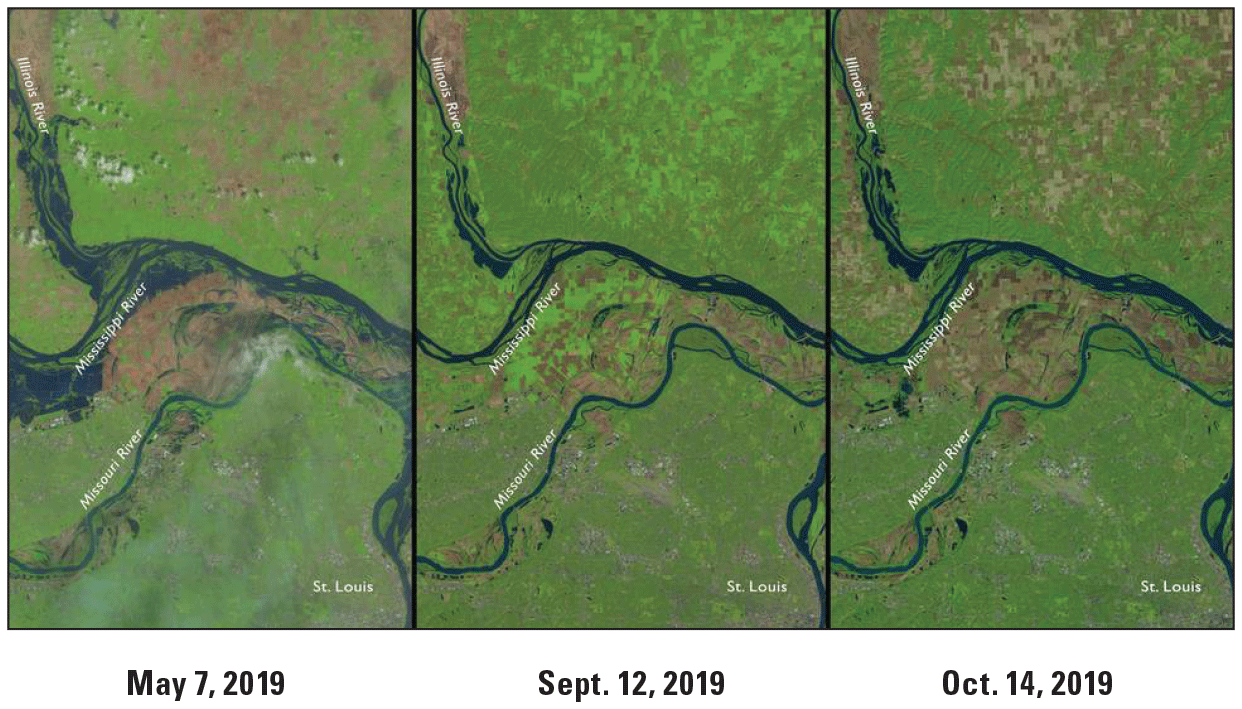
Landsat 8 imagery shows farmland north of St. Louis, Missouri, in the aftermath of spring flooding in 2019. Bright green indicates growing vegetation, light brown indicates harvested fields, and darker brown indicates fallowed fields. Image credit: National Aeronautics and Space Administration.
Monitoring Forest Changes
Forests cover about one-third of Missouri and include more than a dozen species of oak trees, contributing to the economy through timber harvesting (for products from flooring to barrels), recreation, and tourism. Landsat helps the State Forestry Division monitor the health of this important resource and detect changes. For example, imagery has been used to monitor rapid white oak (Quercus alba) mortality and the slower-progressing oak decline, both of which have harmed stands in Missouri (National Association of State Foresters, 2018).
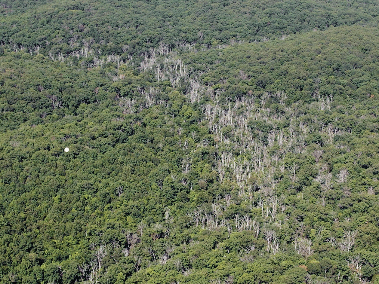
Rapid white oak (Quercus alba) mortality is the cause of the dead trees shown here in Huzzah Conservation Area, Crawford County. Photograph credit: Robbie Doerhoff, Missouri Department of Conservation; used with permission.
Partnering on Geospatial Data Research
The University of Missouri is known for innovative research. One notable example is its Missouri Resource Assessment Partnership (MoRAP). The partnership, staffed by University of Missouri employees, brings together State and Federal agencies, including the USGS, and other organizations. They coordinate technology, expertise, and a variety of geospatial data to help manage natural and cultural resources at a lower cost than they could on their own. One MoRAP project used Landsat data to analyze urban sprawl in several Missouri cities and help planners reduce its negative effects (MoRAP, 2022).

One project by the Missouri Resource Assessment Partnership (MoRAP) used Landsat to look at urban growth over time in several cities, including Springfield. Image credit: MoRAP; used with permission.
National Land Imaging Program Benefits—Missouri
The U.S. Geological Survey (USGS) National Land Imaging Program provides a wide range of satellite imagery and other remotely sensed and geospatial data to Government, commercial, academic, and public users. Those users can get worldwide access to Landsat satellite data through the National Land Imaging Program-funded USGS Earth Resources Observation and Science (EROS) Center.
Landsat—Critical Information Infrastructure for the Nation
Landsat is the most widely used land remote sensing data source within Federal civilian agencies. Local, State, Tribal, and Federal agencies use Landsat to monitor and forecast a wide range of land surface phenomena. Information from Landsat contributes to day-to-day decisions on land, water, and resource use that protect life and property; safeguard the environment; advance science, technology, and education; support climate change resiliency; and grow the U.S. economy. Landsat’s imagery provides a landscape-level view of land surface, inland lake, and coastal processes, both natural and human-induced. Landsat enables us to better understand the scope, nature, and speed of change to the natural and built environment.
Businesses draw upon Landsat data to provide customer-specific applications to improve logistics, resource allocation, and investment decisions. Commercial space imaging firms leverage Landsat data to refine product offerings and support new information services. A 2017 USGS study determined the total annual economic benefit of Landsat data in the United States. to be $2.06 billion, far surpassing its development and operating costs (Straub and others, 2019).
Landsat 8 and Landsat 9 provide 8-day repeat coverage of the Earth’s land surfaces. The National Aeronautics and Space Administration (NASA) and the USGS are currently reviewing the findings from a joint Architecture Study Team, which will inform the design and implementation approach for Landsat Next, the follow-on mission to Landsat 9. Landsat 9 and its successors are planned to provide a sustainable, space-based system to extend the 50-year Landsat series of high-quality global land imaging measurements—the world’s longest time series of the Earth’s land surface.
The long-term availability of consistent and accurate Landsat data, combined with a no-cost data policy, allows users to analyze extensive geographic areas and better understand and manage long-term trends in land surface change. New cloud computing and data analytics technologies use Landsat data in a wide range of decision-support tools for Government and industry. Much like global positioning systems and weather data, Landsat data are used every day to help us better understand our dynamic planet.
References Cited
Gran, R., 2019, Satellites track status of Nation’s food supply: National Aeronautics and Space Administration Landsat Science web page, accessed January 4, 2022, at https://www.nasa.gov/feature/goddard/2019/landsat-data-maps-nation.
Missouri Resource Assessment Partnership [MoRAP], 2022, Urban change detection: Missouri Resource Assessment Partnership website, accessed January 4, 2022, at https://morap.missouri.edu/index.php/urban-change-detection/.
National Association of State Foresters, 2018, State forestry agency input: Importance of Landsat and NAIP data—Letter to USGS containing State position statements: National Association of State Foresters, accessed January 4, 2022, at https://www.southernforests.org/legislation/position-statements/other-administration-policy/NASF%20Letter%20to%20USGS%20on%20Proposed%20Landsat%20Fees %20-%20Sept.%202018.pdf.
Straub, C.L., Koontz, S.R., and Loomis, J.B., 2019, Economic valuation of Landsat imagery: U.S. Geological Survey Open-File Report 2019–1112, 13 p., accessed January 4, 2022, at https://doi.org/10.3133/ofr20191112.
For additional information on Landsat, please contact:
Program Coordinator
USGS National Land Imaging Program
12201 Sunrise Valley Drive
Reston, VA 20192
703–648–4567
The Landsat series is a joint effort of USGS and NASA. NASA develops and launches the spacecraft; USGS manages satellite operations, ground reception, data archiving, product generation, and data distribution. Funding for the National Land Imaging Program’s Landsat operations and data management is provided through the USGS.
Suggested Citation
U.S. Geological Survey, 2022, Missouri and Landsat (ver. 1.1, January 2023): U.S. Geological Survey Fact Sheet 2022–3015, 2 p., https://doi.org/10.3133/fs20223015.
ISSN: 2327-6932 (online)
ISSN: 2327-6916 (print)
Study Area
| Publication type | Report |
|---|---|
| Publication Subtype | USGS Numbered Series |
| Title | Missouri and Landsat |
| Series title | Fact Sheet |
| Series number | 2022-3015 |
| DOI | 10.3133/fs20223015 |
| Edition | Version 1.0: March 16, 2022; Version 1.1: January 19, 2023 |
| Year Published | 2022 |
| Language | English |
| Publisher | U.S. Geological Survey |
| Publisher location | Reston, VA |
| Contributing office(s) | Earth Resources Observation and Science (EROS) Center |
| Description | 2 p. |
| Country | United States |
| State | Missouri |
| Online Only (Y/N) | N |
| Google Analytic Metrics | Metrics page |