

North Carolina and Landsat
Links
- Document: Report (13.4 MB pdf) , HTML , XML
- Download citation as: RIS | Dublin Core
Abstract
North Carolina’s rich history and importance in the colonial days played a critical role in the Nation’s economic development. It was also the setting for events like the Wright Brothers’ famous first flight of a powered aircraft, called “Wright Flyer,” which took place in Kitty Hawk in 1903. Today, North Carolina license plates proudly proclaim the State as “First in Flight.”
The aerospace and defense sectors remain large players in the State’s economy to this day. Boeing, Lockheed Martin, General Electric Aviation, and others maintain a presence in the Tar Heel State, and military installations dot the landscape.
It is fitting, then, that North Carolinians rely upon a satellite system to monitor and study the health of their State’s vast and varied terrain: its coastal plain, the sweeping valleys and peaks of the Blue Ridge Mountains, and the fertile rolling plateau of the Piedmont ecoregion that separates the two. The USGS Landsat satellite program’s unparalleled 50-year record of Earth surface change offers scientists, watershed and land managers, urban planners, and others insight into landscape change, both drastic and mild. Landsat observations document everything from posthurricane floods that push inland to subtle shifts in forest composition and coastal encroachment on urban and military infrastructure.
Here are just a few examples of how Landsat benefits North Carolina.
Watching Over Forests
More than one-half of North Carolina’s land area is covered in forest. The timber industry contributed nearly $35 billion to the State economy in 2019, employing more than 73,600 people (Parajuli and Bardon, 2021). Yet these forests also draw visitors for recreation and are, therefore, a key component of the State’s tourism industry. North Carolina leads the Nation in the number of acres located within the wildland urban interface, or WUI (North Carolina Forest Service, 2017). WUIs comprise areas where homes and forests intermingle, putting homes at risk during wildfires. Landsat data can be used to map fire perimeters in near-real time and assess post-fire damage, as well as to map vegetation types and fuel loads for long-term planning and wildfire management.
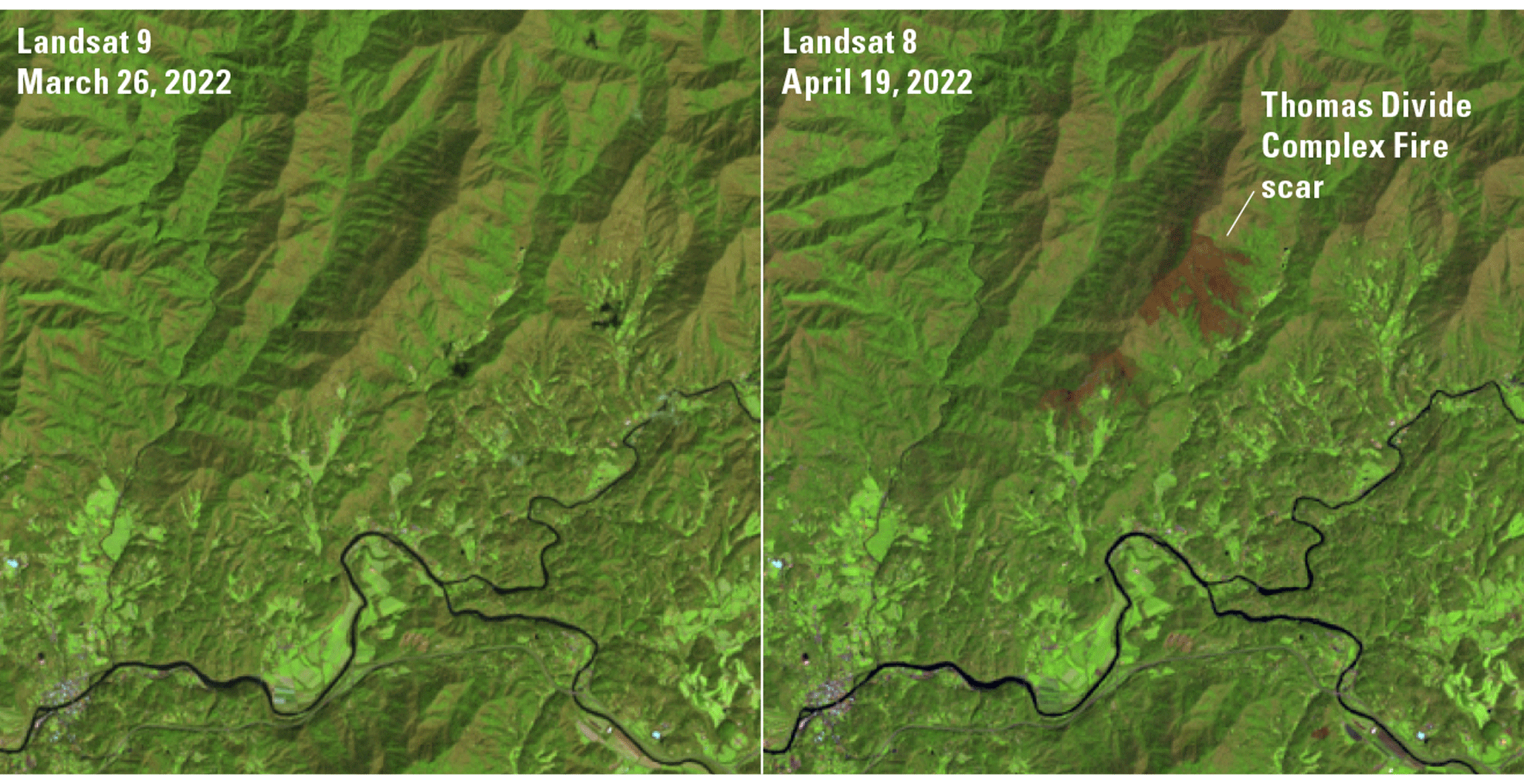
False color images from Landsat 8 and 9 show the scar of the Thomas Divide Complex Fire, which ignited in Great Smoky Mountain National Park in spring 2022.
Mapping the Coastlines
North Carolina’s sandy beaches draw millions of visitors each year, and its shorelines and coastal estuaries provide critical habitat for wildlife. Assessing such dynamic coastline change from erosion, sea-level rise, and more frequent hurricanes and tropical storms would be difficult without the aid of repeat Earth observation imagery from the Landsat program. As early as 1978, scientists used Landsat data to assess coastal changes to Croatan Sound and Pamlico Sound (Welby, 1978). Mapping methods and computing power have improved as the Landsat archive has grown, enabling modern research teams to track coastline change trends across the decades (Pardo-Pascual and others, 2018).
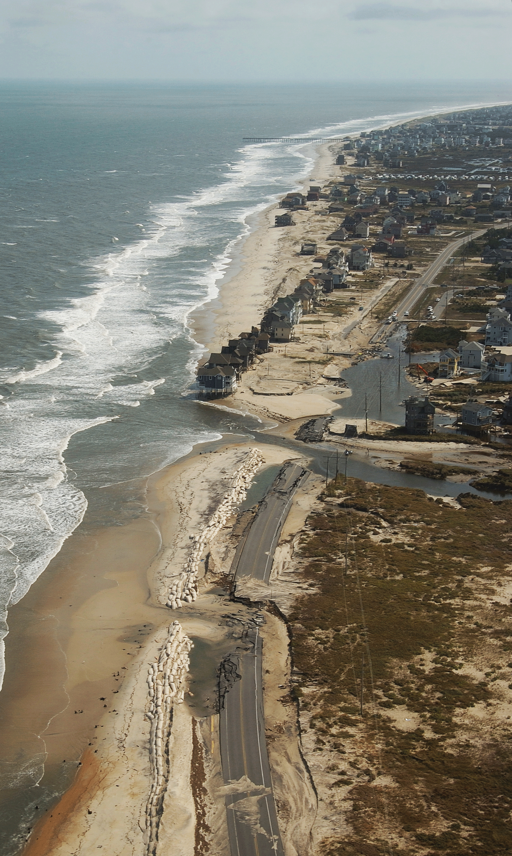
A breach in the coastline of Rodanthe, North Carolina, caused by Hurricane Irene in 2011. Repeated storm effects, combined with sea-level rise, make the development and improvement of models that help forecast coastal change important to local planners.
Urban Growth
Nearly a million people moved to North Carolina between 2010 and 2020, most to metropolitan areas, marking a 9.5-percent growth rate—faster than the national average of 7.3 percent (Tippett, 2021). Accompanying this urban growth is landscape alteration, which is forcing city planners to more sustainably manage phenomena such as increased runoff, wetlands and wildlife habitat impacts, and the urban heat island (UHI) effect, whereby impervious surfaces capture and retain more heat and cause higher temperatures in cities than in the rural areas surrounding them. Landsat is helpful for UHI studies because of its thermal sensor capabilities. Military installations in North Carolina such as Camp Lejeune have also used Landsat to study urban growth and ecosystem performance on military land, particularly as urban development begins to encroach on military operations (Harrell, 2010).
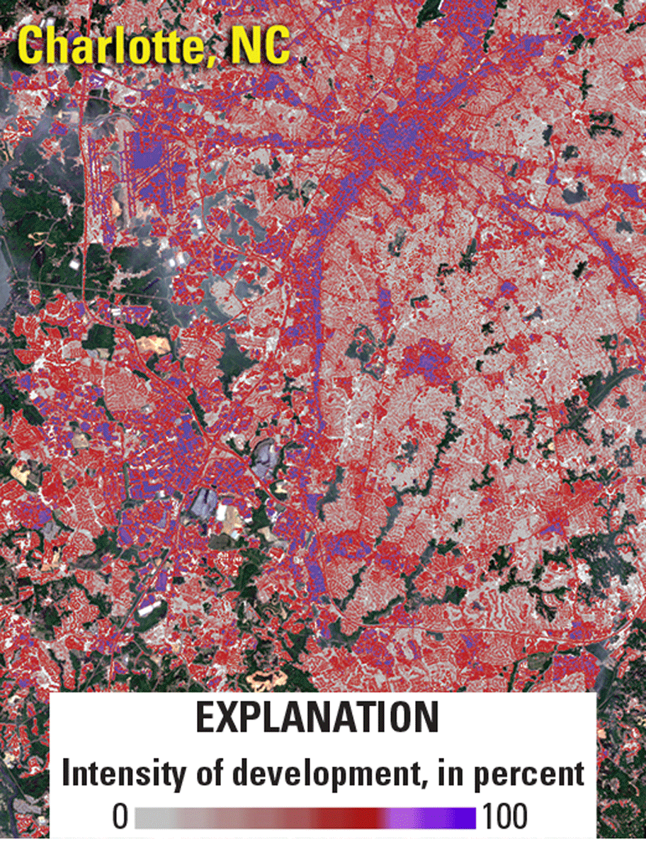
Landsat helps map the intensity of development across the Nation. This image shows Charlotte, North Carolina.
National Land Imaging Program Benefits—North Carolina
The U.S. Geological Survey (USGS) National Land Imaging Program provides a wide range of satellite imagery and other remotely sensed and geospatial data to Government, commercial, academic, and public users. Those users can get worldwide access to Landsat satellite data through the National Land Imaging Program-funded USGS Earth Resources Observation and Science (EROS) Center.
Landsat—Critical Information Infrastructure for the Nation
Landsat is the most widely used land remote sensing data source within Federal civilian agencies. Local, State, Tribal, and Federal agencies use Landsat to monitor and forecast a wide range of land surface phenomena. Information from Landsat contributes to day-to-day decisions on land, water, and resource use that protect life and property; safeguard the environment; advance science, technology and education; support climate change resiliency; and grow the U.S. economy. Landsat’s imagery provides a landscape-level view of land surface, inland lake, and coastal processes, both natural and human-induced. Landsat enables us to better understand the scope, nature, and speed of change to the natural and built environment.
Businesses draw upon Landsat data to provide customer-specific applications to improve logistics, resource allocation, and investment decisions. Commercial space imaging firms leverage Landsat data to refine product offerings and support new information services. A 2017 USGS study determined the total annual economic benefit of Landsat data in the U.S. to be $2.06 billion, far surpassing its development and operating costs (Straub and others, 2019).
Landsat 8 and Landsat 9 provide 8-day repeat coverage of the Earth’s land surfaces. The National Aeronautics and Space Administration (NASA) and the USGS are currently reviewing the findings from a joint Architecture Study Team, which will inform the design and implementation approach for Landsat Next, the follow-on mission to Landsat 9. Landsat 9 and its successors are planned to provide a sustainable, space-based system to extend the 50-year Landsat series of high-quality global land imaging measurements—the world’s longest time series of the Earth’s land surface.
The long-term availability of consistent and accurate Landsat data, combined with a no-cost data policy, allows users to analyze extensive geographic areas and better understand and manage long-term trends in land surface change. New cloud computing and data analytics technologies use Landsat data in a wide range of decision-support tools for Government and industry. Much like global positioning systems and weather data, Landsat data are used every day to help us better understand our dynamic planet.
The Landsat series is a joint effort of USGS and NASA. NASA develops and launches the spacecraft; USGS manages satellite operations, ground reception, data archiving, product generation, and data distribution. Funding for the National Land Imaging Program’s Landsat operations and data management is provided through the USGS.
References Cited
Harrell, P., 2010, Marine Corps Base Camp Lejeune greenness gain from 1984 to 1990: Defense Coastal/Estuarine Research Program, ESS-DIVE repository dataset, accessed December 21, 2021, at https://doi.org/10.15485/1603061.
North Carolina Forest Service, 2017, The wildland/urban interface: North Carolina Forest Service web page, accessed December 31, 2021, at https://www.ncforestservice.gov/fire_control/fc_wui.htm.
Parajuli, R., and Bardon, R., 2021, Economic contribution of the forest sector in North Carolina: N.C. Cooperative Extension web page, accessed December 31, 2021, at https://content.ces.ncsu.edu/economic-contribution-of-the-forest-sector-in-north-carolina.
Pardo-Pascual, J.E., Sánchez-García, E., Almonacid-Caballer, J., Palomar-Vázquez, J.M., Priego de los Santos, E., Fernández-Sarría, A., and Balaguer-Beser, Á., 2018, Assessing the accuracy of automatically extracted shorelines on microtidal beaches from Landsat 7, Landsat 8 and Sentinel-2 imagery: Remote Sensing (Basel), v. 10, no. 2, p. 326, accessed December 21, 2021, at https://doi.org/10.3390/rs10020326.
Straub, C.L., Koontz, S.R., and Loomis, J.B., 2019, Economic valuation of Landsat imagery: U.S. Geological Survey Open-File Report 2019–1112, 13 p., accessed October 13, 2021, at https://doi.org/10.3133/ofr20191112.
Tippett, R., 2021, NC growth over last decade entirely from adult population: Carolina Demography article, accessed December 31, 2021, at https://www.ncdemography.org/2021/08/16/nc-growth-over-last-decade-entirely-from-adult-population/.
Welby, C.W., 1978, Application of Landsat imagery to shoreline erosion: Photogrammetric Engineering and Remote Sensing, v. 44, no. 9, p. 1173–1177, accessed December 21, 2021, at https://www.asprs.org/wp-content/uploads/pers/1978journal/sep/1978_sep_1173-1177.pdf.
For additional information on Landsat please contact:
Program Coordinator
USGS National Land Imaging Program
12201 Sunrise Valley Drive
Reston, VA 20192
703–648–5953
The Landsat series is a joint effort of USGS and NASA. NASA develops and launches the spacecraft; USGS manages satellite operations, ground reception, data archiving, product generation, and data distribution. Funding for the National Land Imaging Program’s Landsat operations and data management is provided through the USGS.
Suggested Citation
U.S. Geological Survey, 2022, North Carolina and Landsat: U.S. Geological Survey Fact Sheet 2022–3038, 2 p., https://doi.org/10.3133/fs20223038.
ISSN: 2327-6932 (online)
ISSN: 2327-6916 (print)
Study Area
| Publication type | Report |
|---|---|
| Publication Subtype | USGS Numbered Series |
| Title | North Carolina and Landsat |
| Series title | Fact Sheet |
| Series number | 2022-3038 |
| DOI | 10.3133/fs20223038 |
| Year Published | 2022 |
| Language | English |
| Publisher | U.S. Geological Survey |
| Publisher location | Reston, VA |
| Contributing office(s) | Earth Resources Observation and Science (EROS) Center |
| Description | 2 p. |
| Country | United States |
| State | North Carolina |
| Online Only (Y/N) | N |
| Google Analytic Metrics | Metrics page |