

Montana and Landsat
Links
- Document: Report (4.46 MB pdf) , HTML , XML
- Download citation as: RIS | Dublin Core
Abstract
The landscapes beneath Montana’s big sky are as breathtaking as the State’s nickname would suggest. Visitors to the 41st State’s “Big Sky Country” can take in the stunning icy hues of aquamarine at Glacier National Park; explore the northern swaths of Yellowstone National Park; or hike, bike, or boat through Bighorn Canyon National Recreation Area, and those are just the National parks.
Montana is the fourth-largest State by land area, with miles upon miles of forests, rolling prairie rangelands, croplands, badlands, and mountains, from which flow a sizable part of the Nation’s water supply. The headwaters of the Missouri River, which covers 2,341 miles before merging with the Mississippi River, are located in Three Forks, Montana. On the opposite side of the Continental Divide, the Kootenai, Clark Fork, Blackfoot, Bitterroot, and Flathead Rivers flow across Montana and into the Columbia River, which ultimately empties into the Pacific Ocean.
The Treasure State’s cherished landscapes face many threats, however: fire-fueling invasive grasses, increasing temperatures caused by climate change, shifting land use patterns, water supply contractions, and more. The USGS Landsat satellite program’s imagery can improve Montanans’ understanding of land change and offer valuable insight for the ranchers, farmers, land and resource managers, firefighters, and urban planners.
Here are just a few examples of how Landsat benefits Montana.
Managing Rangeland Health
More than 70 percent of Montana’s land area, or 68 million acres, is covered in rangelands. Cattle roam and forage across these wide-open spaces, and the beef industry is worth $2.2 billion to the State. For decades, invasive plant species such as Bromus tectorum L. (cheatgrass) have infiltrated Montana, overwhelming sagebrush landscapes and creating substantial fire risk. Landsat observations help research teams to build tools that can guide wise decisions on invasive species management in Montana. In the late 2010s, the Western Governors’ Association partnered with the University of Montana to build a Landsat-based tool that breaks rangelands into their component parts (sagebrush, annual herbaceous, bare ground, and so on). These categorizations and related analyses help land managers target areas of invasion for restoration, preserve uninvaded areas, and assess wildfire risk (U.S. Geological Survey, 2020).
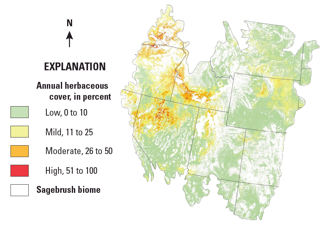
A map depicting the amount of annual herbaceous cover (primarily cheatgrass) across the western United. States. Data are based on the weighted average of the USGS Back in Time fractional component time series, USGS Harmonized Landsat-Sentinel data, and the University of Montana Rangeland Analysis Platform products—all from 2016 to 2018.
Monitoring Mountain Snow and Ice
The wonders of Glacier National Park thrill visitors, but warming temperatures and shifting climate patterns have had a substantial effect on the namesake features of the 1,583-square-mile wilderness preserve. The USGS Northern Rocky Mountain Science Center has documented losses in all glacial areas of the park since 1966, with an average area reduction of 39 percent and a maximum of 85 percent at Boulder Glacier (Florentine, 2019). That reality has implications well beyond visitor satisfaction; glacial meltwater is an important source of moisture and streamflow in Montana. Landsat’s long-term, repeat observations help research teams to track glacial retreat. One team of researchers built an automated system for mapping persistent snow and ice cover across the United States in 2015 using Landsat data. They determined that snow and ice cover has declined at an even greater rate than had been previously estimated (Selkowitz and Forster, 2016).
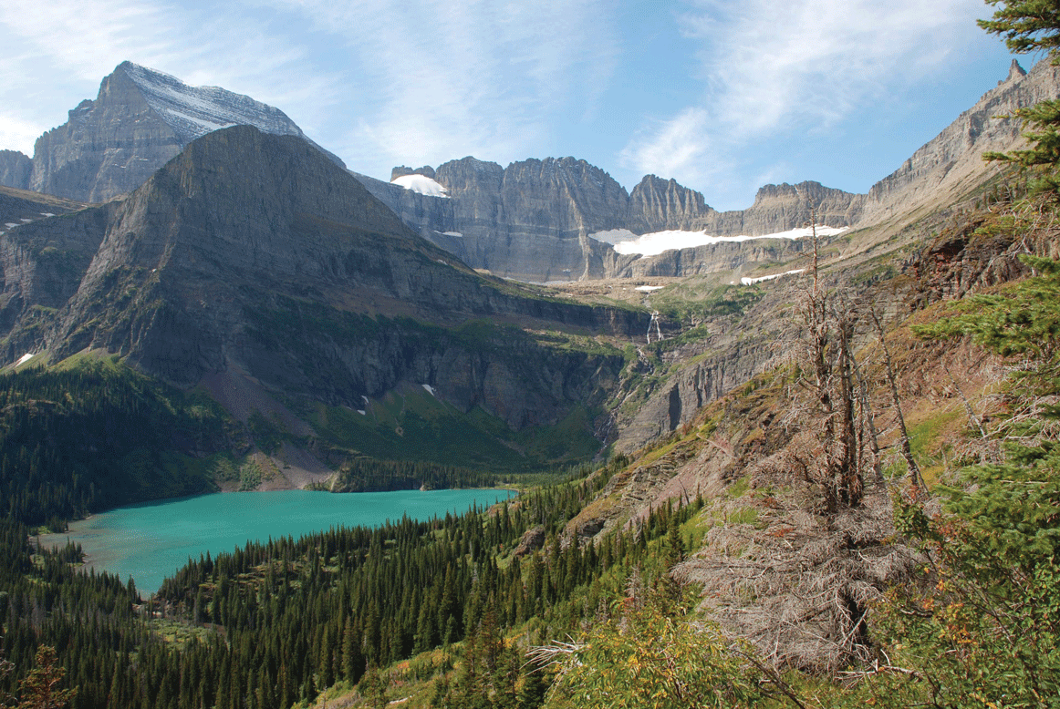
Grinnell Glacier in Glacier National Park, Montana.
Tracking Water Use from Space
Nearly 2 million acres of Montana cropland was irrigated in 2019, making irrigation an important component of the State’s $4.4 billion agriculture industry. Competition for scarce water resources is among the reasons farmers, ranchers, water managers, and researchers lean on Landsat. Thermal sensors make it possible to map evapotranspiration (ET), or the combined rate of water loss through evaporation from the Earth’s surface and transpiration from plant leaves. Absent satellite observations, the measurement of ET can only be completed with flux towers on the ground. Multiple researchers have formulated methods for calculating ET estimates at a wide scale using Landsat observations, which can help guide resource allocation decisions; for example, USGS researchers have used ET models developed by the USGS EROS Center to track field-scale water use across the St. Mary-Milk River drainage basin for the U.S.-Canada International Joint Commission, which manages lakes and rivers at the United States-Canadian border (U.S. Geological Survey, 2021).
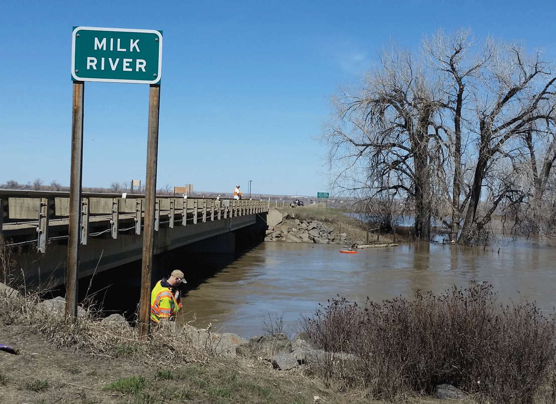
Streamflow measurement at Milk River near Harlem, Montana. Scientists use Landsat data to measure ET, a measurement of water use efficiency valuable in water resource allocation decisions.
National Land Imaging Program Benefits—Montana
The U.S. Geological Survey (USGS) National Land Imaging Program provides a wide range of satellite imagery and other remotely sensed and geospatial data to Government, commercial, academic, and public users. Those users can get worldwide access to Landsat satellite data through the National Land Imaging Program-funded USGS Earth Resources Observation and Science (EROS) Center.
Landsat—Critical Information Infrastructure for the Nation
Landsat is the most widely used land remote sensing data source within Federal civilian agencies. Local, State, Tribal, and Federal agencies use Landsat to monitor and forecast a wide range of land surface phenomena. Information from Landsat contributes to day-to-day decisions on land, water, and resource use that protect life and property; safeguard the environment; advance science, technology, and education; support climate change resiliency; and grow the U.S. economy. Landsat’s imagery provides a landscape-level view of land surface, inland lake, and coastal processes, both natural and human-induced. Landsat enables us to better understand the scope, nature, and speed of change to the natural and built environment.
Businesses draw upon Landsat data to provide customer-specific applications to improve logistics, resource allocation, and investment decisions. Commercial space imaging firms leverage Landsat data to refine product offerings and support new information services. A 2017 USGS study determined the total annual economic benefit of Landsat data in the United States to be $2.06 billion, far surpassing its development and operating costs (Straub and others, 2019).
Landsat 8 and Landsat 9 provide 8-day repeat coverage of the Earth’s land surfaces. The National Aeronautics and Space Administration (NASA) and the USGS are currently reviewing the findings from a joint Architecture Study Team, which will inform the design and implementation approach for Landsat Next, the follow-on mission to Landsat 9. Landsat 9 and its successors are planned to provide a sustainable, space-based system to extend the 50-year Landsat series of high-quality global land imaging measurements—the world’s longest time series of the Earth’s land surface.
The long-term availability of consistent and accurate Landsat data, combined with a no-cost data policy, allows users to analyze extensive geographic areas and better understand and manage long-term trends in land surface change. New cloud computing and data analytics technologies use Landsat data in a wide range of decision-support tools for Government and industry. Much like global positioning systems and weather data, Landsat data are used every day to help us better understand our dynamic planet.
References Cited
Florentine, C., 2019, Glacier retreat in Glacier National Park, Montana (ver. 1.1, December 2019): U.S. Geological Survey Fact Sheet 2019–3068, 2 p. [Also available at https://doi.org/10.3133/fs20193068.]
Selkowitz, D.J., and Forster, R.R., 2016, Automated mapping of persistent ice and snow cover across the western U.S. with Landsat: ISPRS Journal of Photogrammetry and Remote Sensing, v. 117, p. 126–140. [Also available at https://doi.org/10.1016/j.isprsjprs.2016.04.001.]
Straub, C.L., Koontz, S.R., and Loomis, J.B., 2019, Economic valuation of Landsat imagery: U.S. Geological Survey Open-File Report 2019–1112, 13 p., accessed January 13, 2022, at https://doi.org/10.3133/ofr20191112.
U.S. Geological Survey, 2021, Landsat will help US and Canada share river's water: U.S. Geological Survey web page, accessed February 25, 2022, at https://www.usgs.gov/news/landsat-will-help-us-and-canada-share-rivers-water.
U.S. Geological Survey, 2020, USGS-University of Montana data layer plays critical role in Western Governors’ new toolkit for invasive species: U.S. Geological Survey web page, accessed February 28, 2022, at https://www.usgs.gov/news/usgs-university-montana-data-layer-plays-critical-role-western-governors-new-toolkit-invasive.
For additional information on Landsat, please contact:
Program Coordinator
USGS National Land Imaging Program
12201 Sunrise Valley Drive
Reston, VA 20192
703–648–4567
The Landsat series is a joint effort of USGS and NASA. NASA develops and launches the spacecraft; USGS manages satellite operations, ground reception, data archiving, product generation, and data distribution. Funding for the National Land Imaging Program’s Landsat operations and data management is provided through the USGS.
Suggested Citation
U.S. Geological Survey, 2022, Montana and Landsat: U.S. Geological Survey Fact Sheet 2022–3041, 2 p., https://doi.org/10.3133/fs20223041.
ISSN: 2327-6932 (online)
ISSN: 2327-6916 (print)
Study Area
| Publication type | Report |
|---|---|
| Publication Subtype | USGS Numbered Series |
| Title | Montana and Landsat |
| Series title | Fact Sheet |
| Series number | 2022-3041 |
| DOI | 10.3133/fs20223041 |
| Year Published | 2022 |
| Language | English |
| Publisher | U.S. Geological Survey |
| Publisher location | Reston, VA |
| Contributing office(s) | Earth Resources Observation and Science (EROS) Center |
| Description | 2 p. |
| Country | United States |
| State | Montana |
| Online Only (Y/N) | N |
| Google Analytic Metrics | Metrics page |