

Geologic Assessment of Undiscovered Gas Resources in Cretaceous–Tertiary Coal Beds of the U.S. Gulf of Mexico Coastal Plain
Links
- Document: Report (15.0 MB pdf) , HTML , XML
- Appendixes:
- Appendix 1 (165 KB pdf) - Input Data Form for the Cretaceous Olmos Coalbed Gas Assessment Unit (50470281)
- Appendix 2 (161 KB pdf) - Input Data Form for the Rio Escondido Basin Olmos Coalbed Gas Assessment Unit (53000281)
- Appendix 3 (168 KB pdf) - Input Data Form for the Wilcox Coalbed Gas Assessment Unit (50470381)
- Related Work: Open-File Report 2017–1111 - Geologic assessment of undiscovered conventional oil and gas resources in the Lower Paleogene Midway and Wilcox Groups, and the Carrizo Sand of the Claiborne Group, of the Northern Gulf coast region
- Download citation as: RIS | Dublin Core
Abstract
The U.S. Geological Survey (USGS) completed an assessment in 2007 of the undiscovered, technically recoverable, continuous gas potential of Cretaceous–Tertiary coal beds of the onshore areas and State waters of the northern Gulf of Mexico Coastal Plain. The assessment was based on geologic elements including hydrocarbon source rocks, availability of suitable reservoir rocks, and hydrocarbon accumulations in three coalbed gas total petroleum systems (TPSs) identified in the region: (1) the Olmos Coalbed Gas TPS (Upper Cretaceous), (2) the Wilcox Coalbed Gas TPS (Paleocene–Eocene), and (3) the Cretaceous-Tertiary Coalbed Gas TPS. Four continuous assessment units (AUs) were defined within these three TPSs: (1) the Cretaceous Olmos Coalbed Gas AU, (2) the Rio Escondido Basin Olmos Coalbed Gas AU, (3) the Wilcox Coalbed Gas AU, and (4) the Cretaceous-Tertiary Coalbed Gas AU, which was not quantitatively assessed and which includes all other Cretaceous and Tertiary coal beds that are not included in the other AUs.
This USGS assessment estimated a mean of 4.06 trillion cubic feet of undiscovered, technically recoverable, continuous coalbed gas resources in the four AUs that were assessed. Nearly all of the undiscovered continuous gas resources that were estimated (95 percent, or 3.86 trillion cubic feet of gas [TCFG]) were in the Wilcox Coalbed Gas AU. The continuous gas resources resided in coalbed reservoirs. Gas sourced from these coal beds may also occur as conventional accumulations in adjacent or interlayered sandstones that were not included in this assessment of continuous resources. The assessment was conducted via the established USGS methodology for continuous petroleum accumulations and reflects estimates of undiscovered resources based on vertical (nonhorizontal) drilling technology.
Introduction
A primary mission of the U.S. Geological Survey (USGS) Energy Resources Program is to conduct geologic assessments of the undiscovered, technically recoverable quantities of oil and gas that have the potential to be added to the proved reserves in the United States (U.S. Geological Survey, 2010). As part of the National Oil and Gas Assessment Project, these assessments are based on an integration and analysis of geologic elements such as hydrocarbon source rocks (source-rock maturation, hydrocarbon generation and migration), reservoir rocks (sequence stratigraphy and petrophysical properties), and hydrocarbon traps (trap formation and timing) within a total petroleum system (TPS) framework (Magoon and Dow, 1994; Schmoker and Klett, 2005; U.S. Geological Survey National Assessment Review Team, 2006; see https://www.usgs.gov/centers/cersc/science/united-states-assessments-undiscovered-oil-and-gas-resources?qt-science_center_objects=0#qt-science_center_objects). A TPS consists of all genetically related petroleum generated by a pod or closely related pods of mature source rocks (Schmoker and Klett, 2005).
The last USGS assessment of the total oil and gas resources in the U.S. Gulf of Mexico Coastal Plain was completed in 1995 (U.S. Geological Survey National Oil and Gas Resource Assessment Team, 1995; Schenk and Viger, 1996a, b). Since then, assessments of the Jurassic–Tertiary intervals in the Gulf of Mexico Coastal Plain were reported by Condon and Dyman (2006), Dyman and Condon (2006), Dubiel and others (2007, 2011), Pitman and others (2007), Eoff and others (2015), Paxton and others (2017a, b), Buursink and others (2018), Hackley and others (2018), Whidden and others (2018), and Roberts-Ashby and others (2019). This report is an update of previous work and is the first to assess the coalbed gas resources of the region. It also serves to document the work conducted during USGS assessments of the Paleogene and Neogene strata in the Gulf of Mexico Coastal Plain (Dubiel and others, 2007; Warwick and others, 2007a; Warwick, 2017).
The discovery of coalbed gas in Cretaceous and Paleocene strata (Warwick and others, 2000a, b, 2002; Barker and others, 2002, 2003) identifies new petroleum systems that were not recognized in previous USGS assessments for the Gulf of Mexico Coastal Plain. Gas production from coal beds across the United States accounted for about 3 percent of U.S. domestic gas production in 2019 (U.S. Energy Information Administration, 2021). The Gulf of Mexico Basin is one of the major hydrocarbon-producing areas of the world and the extensive production infrastructure that could contribute to the development of the region’s coalbed gas resources is already in place.
The purpose of this report is to describe the geological concepts, models, TPSs, and assessment units (AUs) for the Cretaceous–Tertiary coal beds that were assessed in the Dubiel and others (2007) assessment of the remaining technically recoverable oil and gas resources to be found in the Gulf of Mexico Coastal Plain (figs. 1, 2). This report also serves as a guide to help interpret and understand the numerical results of the assessment presented in Dubiel and others (2007) and Warwick and others (2007a). Lastly, the coalbed gas resource assessment presented in this report can also help provide a better understanding of the region’s coalbed gas resources, which may lead to additional coalbed gas exploration and production that will add to the Nation’s domestic gas supply.
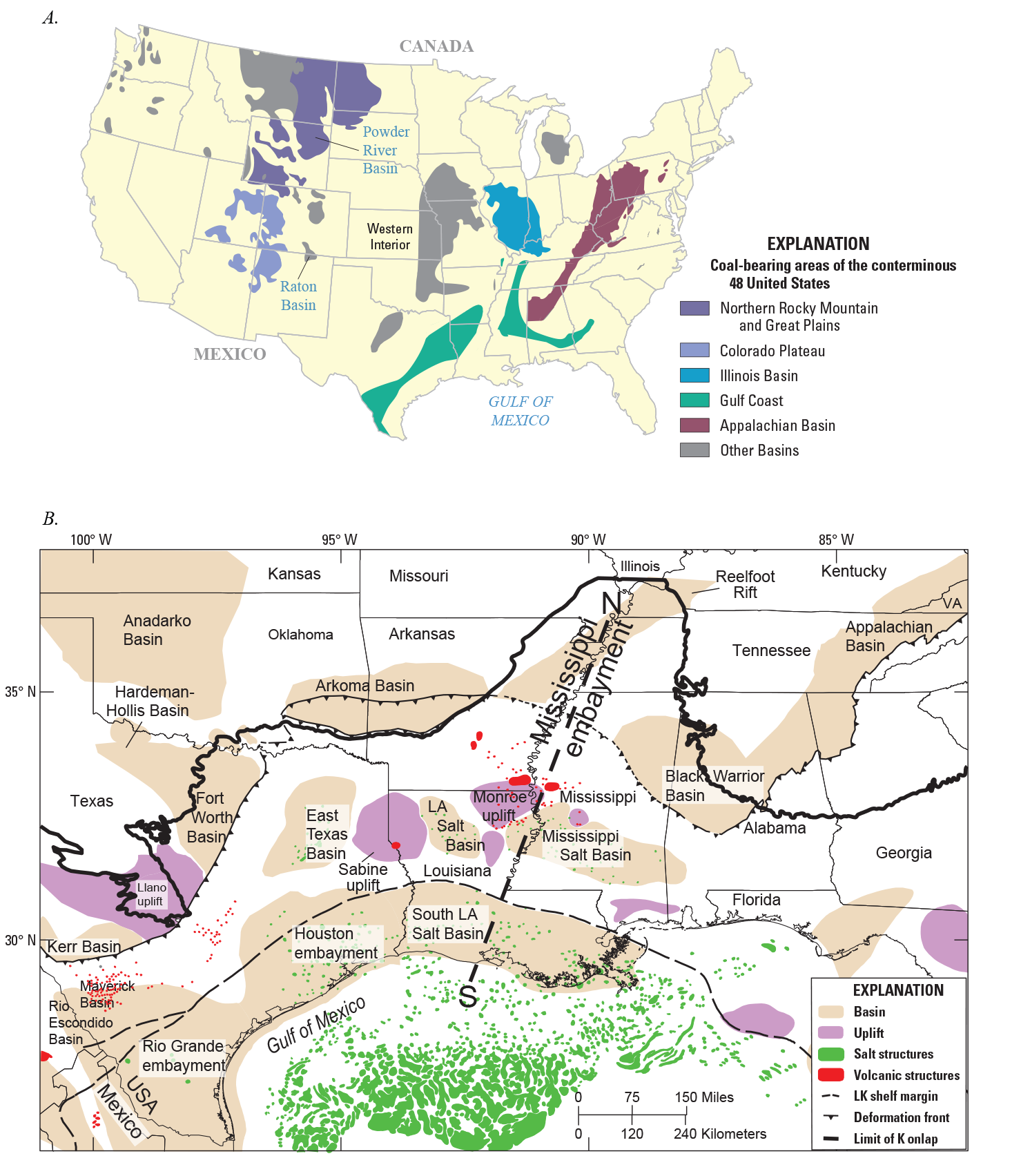
Maps showing coal-bearing areas and structural features of the conterminous United States and northern Gulf of Mexico Basin. A, Coal-bearing areas of the conterminous United States; modified from Tully (1996) and Dennen (2009). The “other basins” in the explanation are those outside of the five priority coal-producing regions assessed for the National Coal Resource Assessment (Dennen, 2009). B, Major surface and subsurface structural features of the northern Gulf of Mexico Basin; modified from Milici (1980), Frezon and Finn (1988), Ewing (1991), Ewing and Lopez (1991), Salvador and Quezada Muñeton (1991), Warwick and others (1997b, 2008), Galloway and others (2000), Coleman and Pratt (2015), and Warwick (2017). Abbreviations: N, S, north and south endpoints for the cross section shown on figure 15; K, Cretaceous; LK, Lower Cretaceous; LA, Louisiana; VA, Virginia.
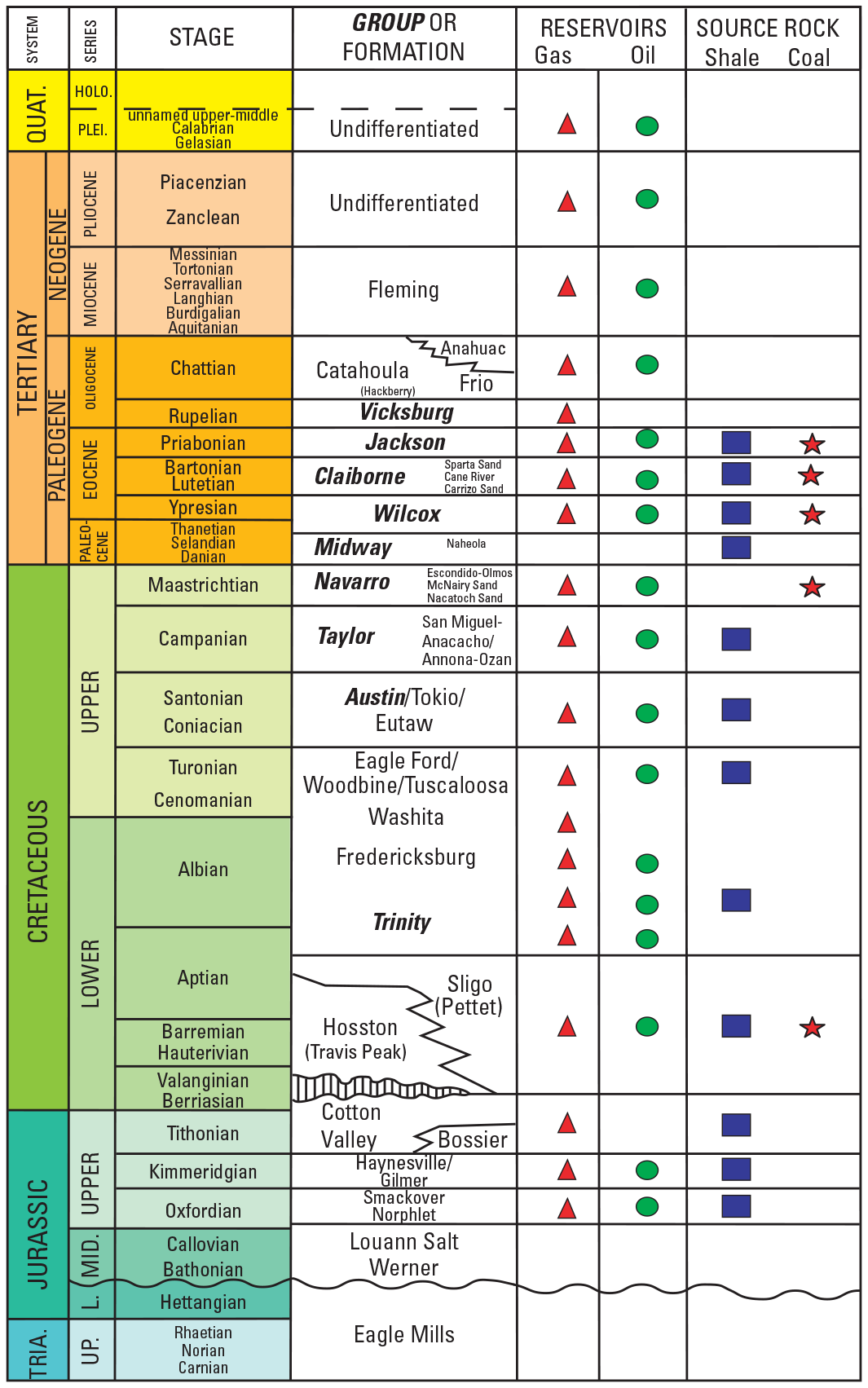
Generalized stratigraphic section of the northern Gulf of Mexico Basin showing gas (triangles) and oil (circles) occurrences as well as potential source rocks (boxes and stars). Group names are bold and italic. Modified from Nehring (1991), Salvador and Quezada Muñeton (1991), Baker (1995), Palmer and Geissman (1999), Humble Geochemical Services and others (2002), Warwick and others (2007b), and Warwick (2017). Abbreviations: L., Lower; MID., Middle; UP., Upper; TRIA., Triassic; PLEI., Pleistocene; HOLO., Holocene; QUAT., Quaternary; evenly spaced vertical lines, unconformity; wavy line, disconformity; jagged line, interfingering; dashed line, uncertain.
Geologic Setting
The Gulf of Mexico Basin is a circular depression that contains strata as much as 9 miles thick that range in age from Late Triassic to Holocene (Ewing, 1991). The structural and stratigraphic setting of the northern Gulf of Mexico Coastal Plain has been well documented by previous studies (Murray, 1961; Ewing, 1991; Salvador, 1991; Cao and others, 1993; Zimmerman, 1995; Hosman, 1996; Galloway and others, 2000; Stephens, 2001). Figure 1B shows the major structural features of the northern part of the Gulf of Mexico Basin, including the Louisiana and Mississippi salt basins where numerous salt structures occur (Ewing and Lopez, 1991; Lopez, 1995). Strata in the Gulf of Mexico Coastal Plain generally dip into the basin, except where local deformation occurs around structural uplifts, subbasins, faults, and folds.
Coal Geology of the Gulf of Mexico Coastal Plain
The coal-bearing strata in the Gulf of Mexico Coastal Plain were deposited in a variety of depositional settings, and the coal ranks range from lignite to bituminous. The primary coal-bearing areas of this region are along the north-northwestern margin of the Gulf of Mexico Basin where coal deposits are found in Upper Cretaceous, Paleocene, and Eocene coastal, deltaic, and fluvial sediments (fig. 3) (Fisher and McGowen, 1967; Galloway, 1968; Ayers and Lewis, 1985; Kaiser, 1990; Breyer, 1991; Sohl and others, 1991; Warwick and others, 2004b). In addition, recent investigations suggest that coalbed gas resources may also exist in Lower Cretaceous rocks of the Hosston Formation or the lower part of the Trinity Group of southeastern Arkansas (Warwick and others, 2000a, b, 2002, 2004a, b, 2011). Drill records from Arkansas indicate that there are Lower Cretaceous coal beds greater than 10 feet (ft) thick at depths of 1,500 to 6,000 ft that may be suitable for coalbed gas development (Warwick and others, 2004b; Hackley and others, 2006a, 2011a). Vitrinite reflectance data obtained from Lower Cretaceous coal cuttings from these depths indicates that maximum vitrinite reflectance (%Ro max) values are as much as 0.54 %Ro max (Hackley and others, 2006a, 2011a). Some wells in northern Louisiana have produced coal cuttings from the Lower Cretaceous section (Jim York, EnerVest Operating LLC, oral commun., 2003), and other reports indicate that there are coal occurrences in the Hosston Formation of southern Texas (Imlay, 1945) and of central Mississippi (Scherer, 1980; Mitchell-Tapping, 1997).
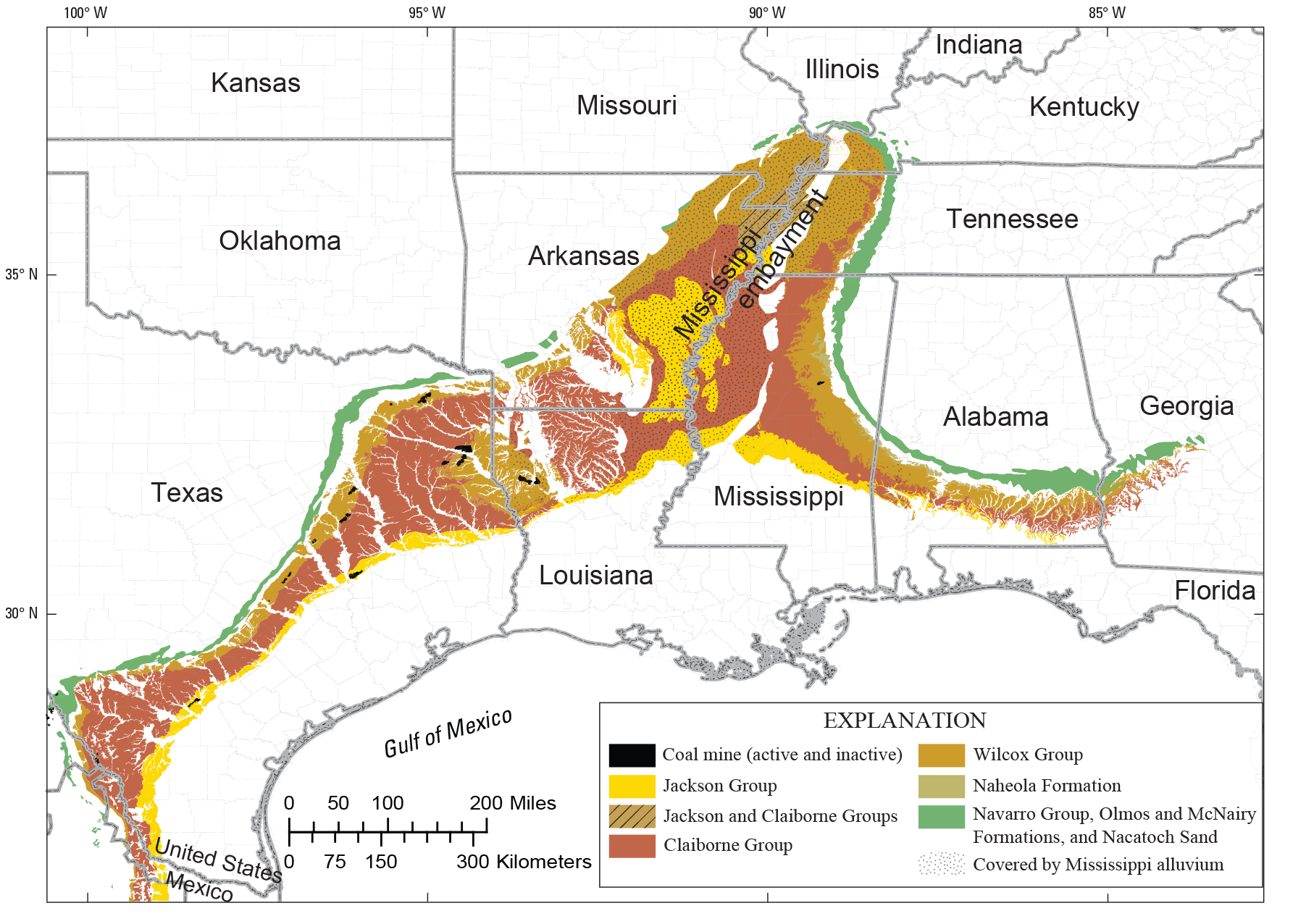
Map showing locations of outcrops of primary coal-bearing units and coal mine locations in the northern Gulf of Mexico Coastal Plain and Mississippi embayment. Geology from Stose and Ljungstedt (1932), Fisk (1944), Warwick and others (1997b), Schruben and others (1994), and Page and others (2005).
Coal-bearing strata extend over much of the Gulf of Mexico Coastal Plain, but basinwide stratigraphic relations and depositional settings are poorly defined. Figure 4 illustrates the lateral and vertical relations of the Upper Cretaceous and Paleocene–Eocene coal-bearing stratigraphic nomenclature; these stratigraphic data were compiled from State geologic maps at the scales of 1:500,000 and 1:250,000 (Miller and others, 1966; Bicker, 1969; Haley and others, 1976; McDowell and others, 1981; Snead and McCulloh, 1984; Osborne and others, 1989; Barnes, 1992). The group and formation names generally follow State usage but have been edited to conform with current USGS terminology; therefore, names may not match correlation schemes used in previously published USGS reports such as those by Cushing and others (1964), Hackman and Meissner (1983), and Hosman (1996).
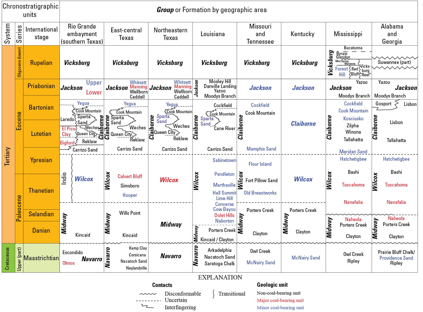
Correlation diagram showing stratigraphic nomenclature of Upper Cretaceous and Paleocene–Eocene coal-bearing and associated strata for the Gulf of Mexico Coastal Plain and the Mississippi embayment. Group names are in bold and italic; text color indicates the degree to which a geologic unit is coal bearing. The diagram generally follows Galloway and others (1991), Salvador and Quezada Muñeton (1991), Baker (1995), Dockery (1996), Warwick and others (1997b), Ogg and others (2008), and Merrill and others (2012). State geologic maps at the scales of 1:500,000 and 1:250,000 were used in this assessment, and group and formation names thereon have been maintained or were edited for conformity with U.S. Geological Survey usage as shown in figures 2 and 3.
Coal is currently mined from several geologic units in the northern Gulf of Mexico Coastal Plain. Bituminous coal zones of the deltaic Navarro Group are currently mined in surface and subsurface mines in northeastern Mexico (Verdugo and Ariciaga, 1991; Gentzis and others, 2006) and southern Texas (fig. 3). In Texas, the coal zones were mined underground until the late 1920s (Evans, 1974); today they are surface mined and are targets for coalbed gas exploration (Barker and others, 2002, 2003; Scott, 2003). The Paleocene–Eocene Wilcox Group crops out across most of the gulf coast coal-bearing region (figs. 3, 5, 6) and has the greatest amount of known coal resources. There are 6 active Wilcox Group lignite surface mines in Texas, 2 in Louisiana, and 1 in Mississippi (fig. 3) (U.S. Energy Information Administration, 2008, 2020; Louisiana Department of Natural Resources, 2009; Railroad Commission of Texas, 2009; Warwick and others, 2011). The Wilcox Group is about 1,000 ft thick in the subsurface near the outcrop areas shown on figures 3, 5 and 6, and thickens downdip (fig. 6) to several tens of thousands of feet offshore. The northern (updip) parts of the Wilcox Group contain fluvial and deltaic coal-bearing facies, whereas the southern (downdip) parts of the basin contain siliciclastic shelf and marine facies. In Texas, lignite is mined from the upper part of the Wilcox Group; whereas, in Louisiana and Mississippi, lignite is mined from the lower part (fig. 4). Individual Wilcox Group coal beds are generally less than 15 ft thick, and most coal mines produce from several beds. Reviews of recent coalbed gas exploration and production activities in the Paleocene–Eocene Wilcox Group can be found in Warwick and others (2002), Warwick (2004b), Breland and Warwick (2005), Warwick and others (2008), and McIntosh and others (2010).
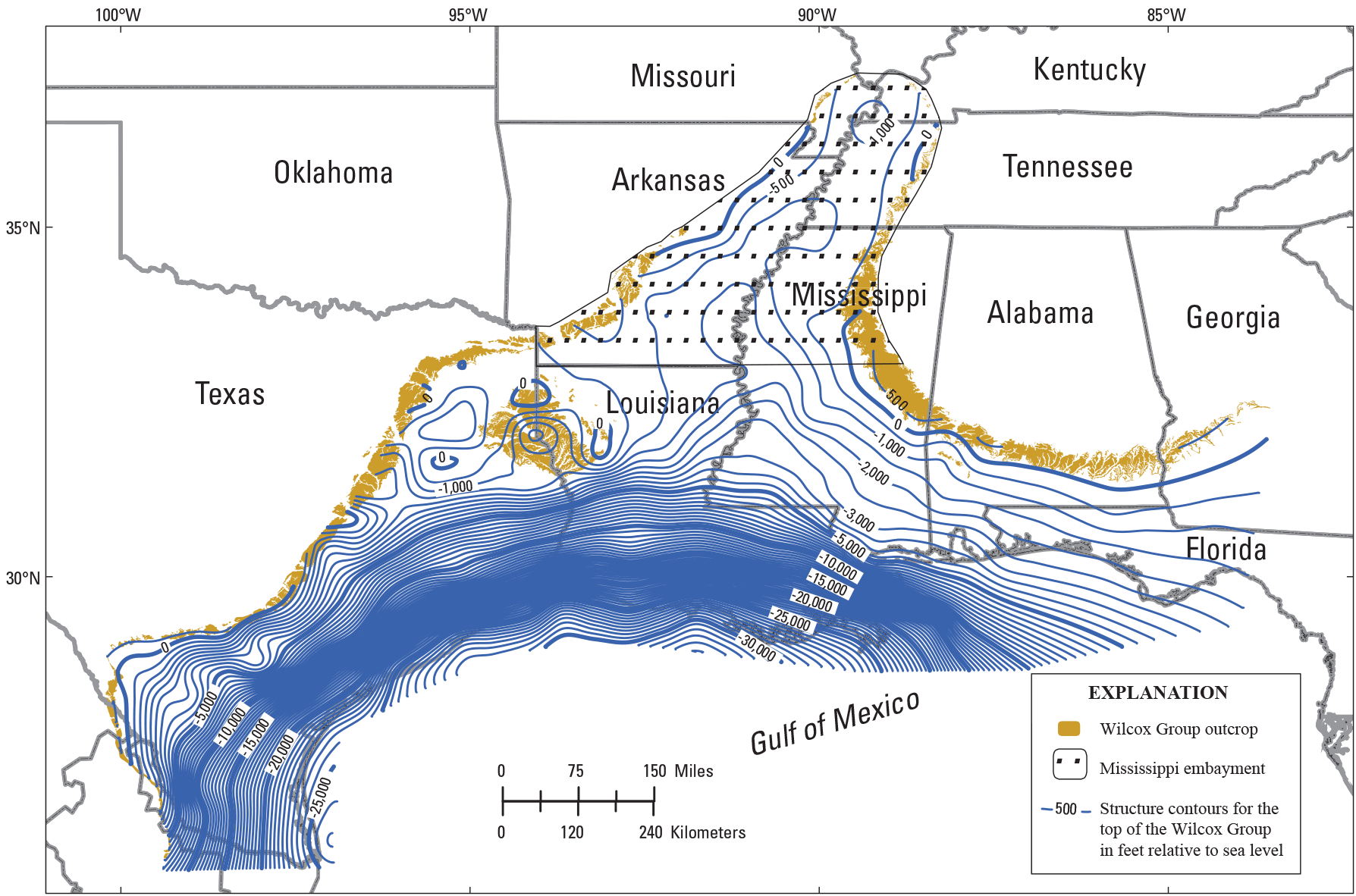
Map showing structure contours for the top of the Wilcox Group in the Gulf of Mexico Coastal Plain and Mississippi embayment. The map is from figure 3 of Warwick (2017) and is based on data from more than 42,000 wells where the top of the Wilcox Group has been determined from the IHS Energy Group database (IHS Energy Group, 2005b). Outcrop geology is from Warwick and others (1997b). Structure contours have been extended to beyond the coastal areas by using control points based on depths to the top of the Wilcox Group from regional cross sections and seismic lines (Ewing, 1991; Salvador, 1991). The contours have been smoothed to remove the local effect of uplifts associated with salt structures. Recent data from ultra-deep wells penetrating the Wilcox Group in the Outer Continental Shelf have not been incorporated into this map. A digital version of this contour map is provided in Sweetkind and Warwick (2022).
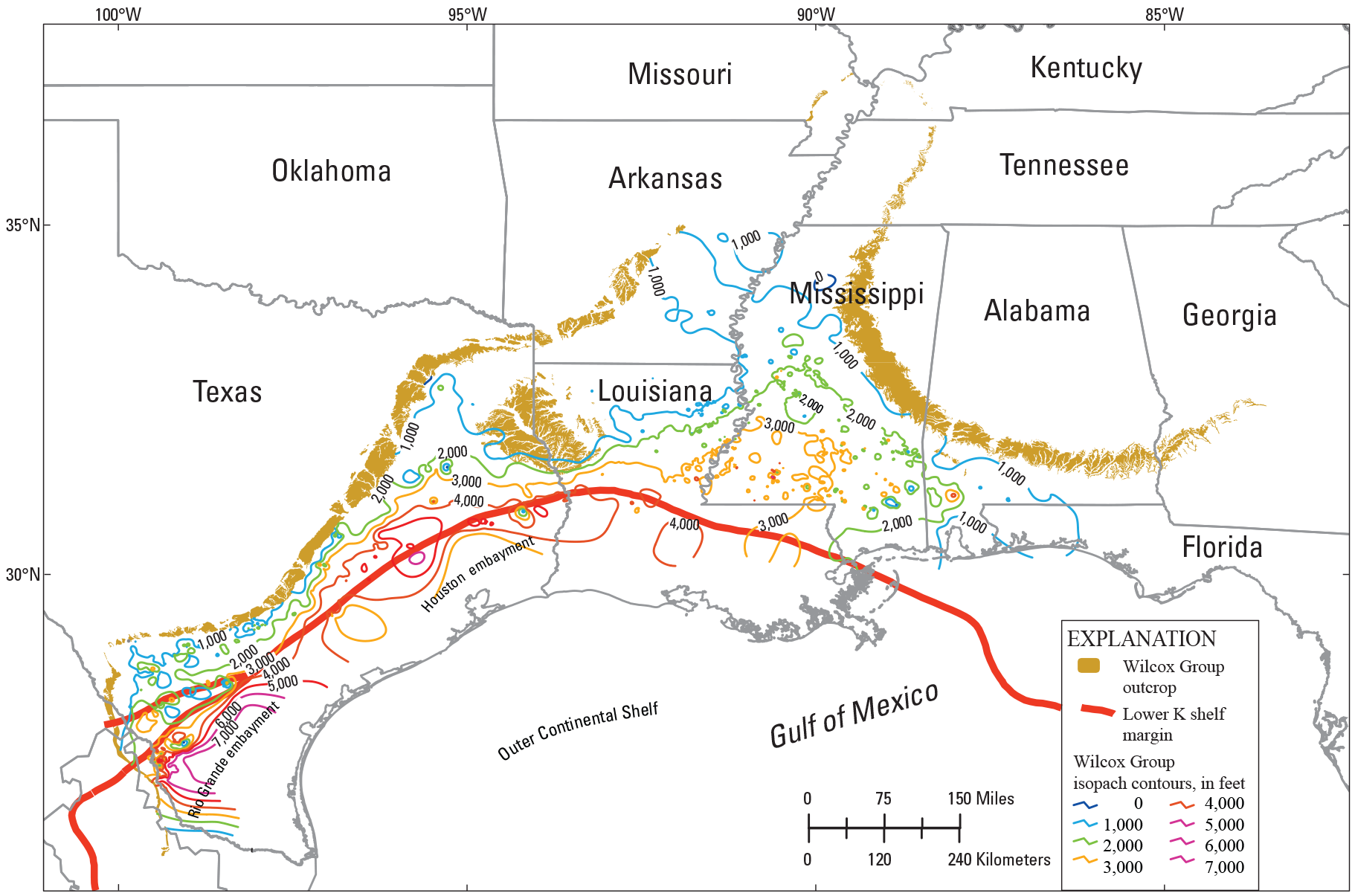
Map showing generalized contours for the subsurface thickness (isopachs) of the Wilcox Group in the Gulf of Mexico Coastal Plain and the Mississippi embayment. The Wilcox Group is coal bearing to the north of the Lower Cretaceous (Lower K) shelf margin. The map is figure 4 from Warwick (2017) and was modified from Barker and others (2000). Outcrop geology is from Warwick and others (1997b); the Lower Cretaceous shelf margin is from Galloway and others (2000).
The deltaic Claiborne Group (figs. 2, 3, 4) overlies the Wilcox Group and contains minor coal resources (Breyer, 1991). In southern Texas, bituminous coals that have a texture and composition similar to those of cannel coals (cannel-like) were mined at the surface from the Claiborne Group (Evans, 1974; Warwick and Hook, 1995; Warwick and others, 1997b; Hook and Warwick, 2011). These coal zones extend into northern Mexico (Flores Galicia, 1991).
The deltaic Jackson Group (figs. 2, 3, 4, 7A) overlies the Claiborne Group across the entire Gulf of Mexico Coastal Plain. The Jackson Group is divided into several formal and informal units across the States where it is present (fig. 4) (Breyer, 1991; Barnes, 1992). Lignite zones in the Jackson Group have been mined in central Texas and are currently mined from surface mines in southern Texas (Warwick and others, 1996, 1997b; Hook and others, 2011d).
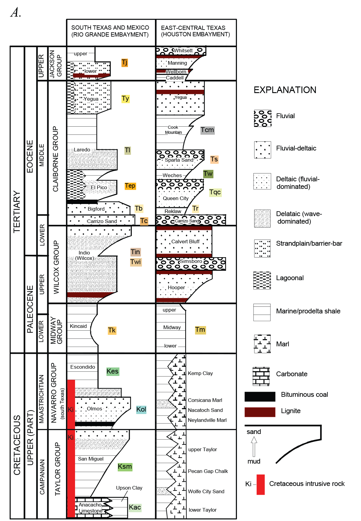
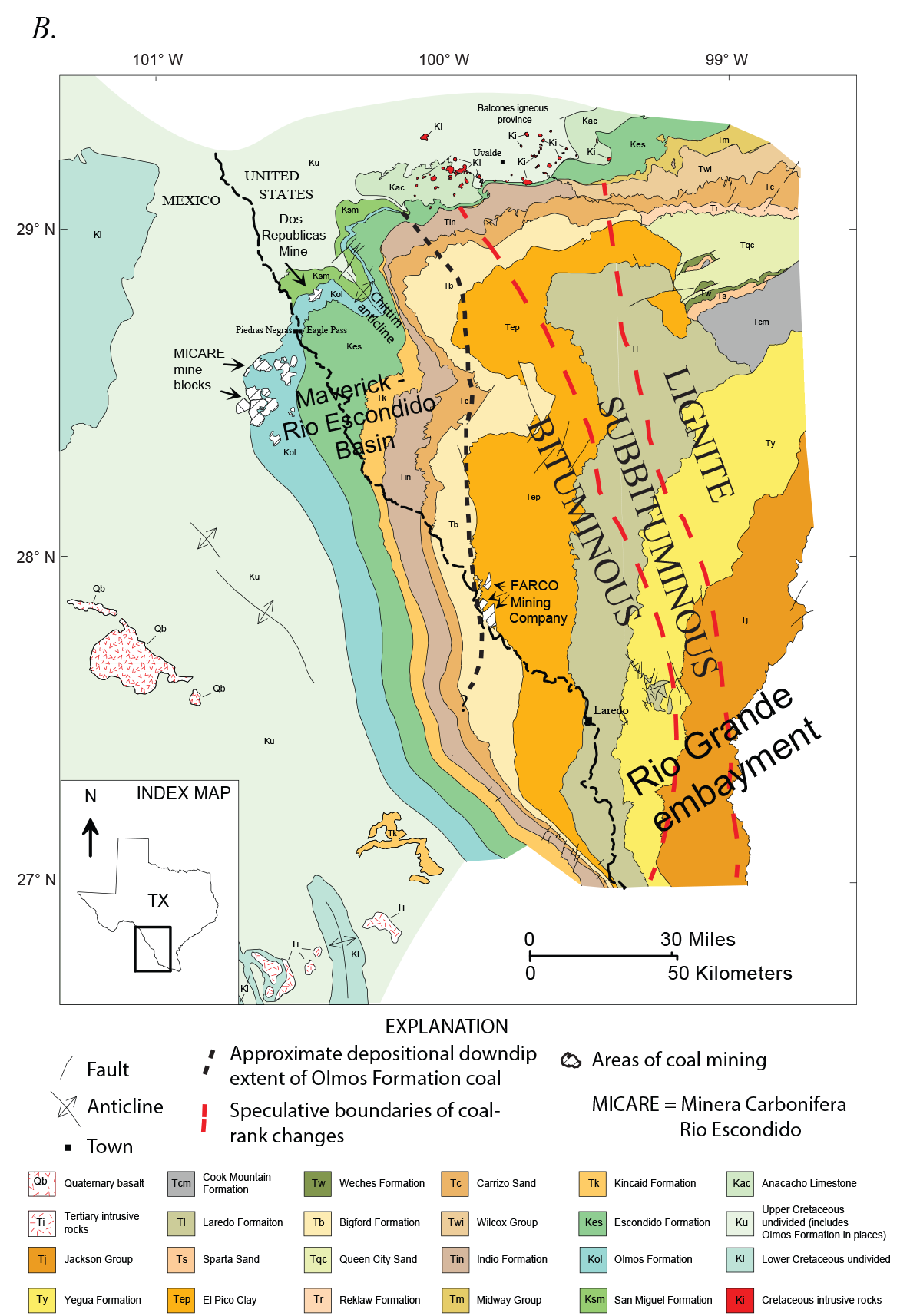
Generalized stratigraphic column and map of regional geology for southern Texas and adjacent Mexico. A, Generalized stratigraphic column for coal-bearing areas in southern Texas and adjacent areas of Mexico and the Houston embayment. The Claiborne Group bituminous coal rank anomaly has been described by Evans (1974) and Warwick and Hook (1995). The stratigraphic position of map units and symbols used are shown on figure 7B. Note that the figure explanation is mostly for depositional environments, but also includes grain sizes and rock types. Figure modified from Ayers and Kaiser (1986), Baker (1995), SanFilipo (1999), and Condon and Dyman (2006). B, Geologic map of the Maverick and Rio Escondido Basins showing the location of bituminous coal-bearing strata of southern Texas and adjacent areas of Mexico. See figure 7A for a stratigraphic summary of the geologic map units. Figure modified from SanFilipo (1999) and Hackley and others (2012).
Origin of Coalbed Gas
Naturally occurring bacteria in peat or coal can generate significant amounts of methane. Gas generated from the decay of organic matter in the peat stage is generally referred to as swamp gas and is not thought to be preserved in the resulting coal beds (Clayton, 1998). Such bacterial gas generation (a process known as methanogenesis) continues throughout the various processes leading to different coal rank stages; if significant amounts of the gas are trapped in the coal or in an adjacent reservoir such as porous sandstone beds, the gas may eventually become an economic gas resource (Warwick, 2005). Many low-rank coal deposits—such as those in the northern Gulf of Mexico Basin—owe their coalbed methane (CBM) resources to solely biogenic activity (Rice, 1993; Clayton, 1998; Warwick and others, 2008; McIntosh and others, 2010).
Diagenesis and coalification are the processes by which buried plant material is altered (metamorphosed) to form coal. During these processes, the original organic material is geochemically altered by heat and pressure for relatively long periods of geologic time (Levine, 1993; Taylor and others, 1998; Warwick, 2005). In the bituminous coal stage, organic material is heated to where the hydrogen-rich components generate bitumen, which is a gelatinous mixture of hydrocarbons similar to oil. These bitumens can fill open pore spaces in the coal or they can be expelled and can migrate away from the coal bed to become trapped in conventional oil reservoirs (Littke and Leythaeuser, 1993; Wilkins and George, 2002). Because of this change in chemical properties, the physical nature of the coal also changes. The internal microporosity of the coal decreases, which contributes to an increase in density. If the coal is buried deeper and (or) is subjected to increased heat, the bitumen cracks into smaller molecules and then gases such as methane and carbon dioxide are released. These gases can be adsorbed into the coal structure and, in the case of methane, can become an economic source of natural gas. This type of methane is described as thermogenic because it was generated by thermal (heating) processes within the earth; methane of this kind accounts for most of the gas currently being produced from the Maverick Basin in southern Texas and other bituminous coal basins in the United States. In many coal-bearing basins, a mixture of biogenic and thermogenic coalbed gas is produced from the well bore. For a detailed discussion of the origin of coalbed gas, see Rice (1993) and Clayton (1998).
Methods
Thirty-three conventional AUs were identified in the 2007 USGS assessment of the undiscovered, technically recoverable, conventional oil and gas resources and continuous coalbed gas resources in Paleogene and Neogene strata underlying the U.S. Gulf of Mexico Coastal Plain and State waters (Dubiel and others, 2007). Four Cretaceous–Paleogene continuous (coalbed gas) AUs were included in this assessment. The initial numerical results of the assessment can be found in USGS fact sheets by Dubiel and others (2007) and Warwick and others (2007a). The methodology used for the conventional AUs follows that described in Charpentier and Klett (2005), Klett and others (2005), and Schmoker and Klett (2005). The methodology used for assessing the continuous AUs is described in Cook (2005), Crovelli (2005), Klett and Schmoker (2005), and Schmoker (2005). Methodology for developing estimated ultimate recovery (EUR) plots for coalbed gas AUs follows that outlined in Cook (2005).
Some well and field production data used in the USGS assessment of continuous coalbed gas resources in the Gulf of Mexico Coastal Plain are from proprietary commercial datasets of the IHS Energy Group (2005a, b) and from Nehring Associates, Inc. (2006). Data from these commercial databases are subject to proprietary constraints, and the USGS may not publish, share, or serve any data from these databases. However, the USGS may prepare and publish derivative representations in the form of graphs and summary statistics for each AU. The IHS production database includes oil and gas production data for wells, leases, and producing units (collectively called “entities” in these databases). The IHS oil and gas wells database includes individual well data (including data for dry holes) such as well identification, locations, and information on penetrated and producing formations. Oil and gas field databases include location, geologic characterization, and oil and gas production data for domestic oil and gas fields and reservoirs (U.S. Geological Survey National Assessment Review Team, 2006). The USGS does not verify the accuracy, completeness, or currency of data reported in these commercial databases.
Because coalbed gas exploration and development in the Gulf of Mexico Coastal Plain is relatively new, well and production data have not been fully incorporated in the IHS and Nehring Associates databases described above. Accordingly, this assessment relied heavily on publicly available well and production data accessed from State regulatory websites (Louisiana Department of Natural Resources, 2007; Railroad Commission of Texas, 2007).
Resource Assessment
In October of 2006, the USGS Gulf Coast Assessment Team met at the USGS offices in Denver, Colorado, to review the petroleum geology related to Tertiary conventional and Cretaceous–Tertiary coal bed continuous assessment intervals for the onshore and State waters portion of the U.S. Gulf of Mexico Coastal Plain. This meeting led to defining a composite Jurassic–Cretaceous–Tertiary TPS and the associated conventional AUs that are described in Warwick and others (2007b). Three coalbed gas TPSs were identified in the Gulf of Mexico Coastal Plain and four continuous AUs were defined within the three TPSs (fig. 8). The coalbed gas TPSs and the AUs are described in detail below.
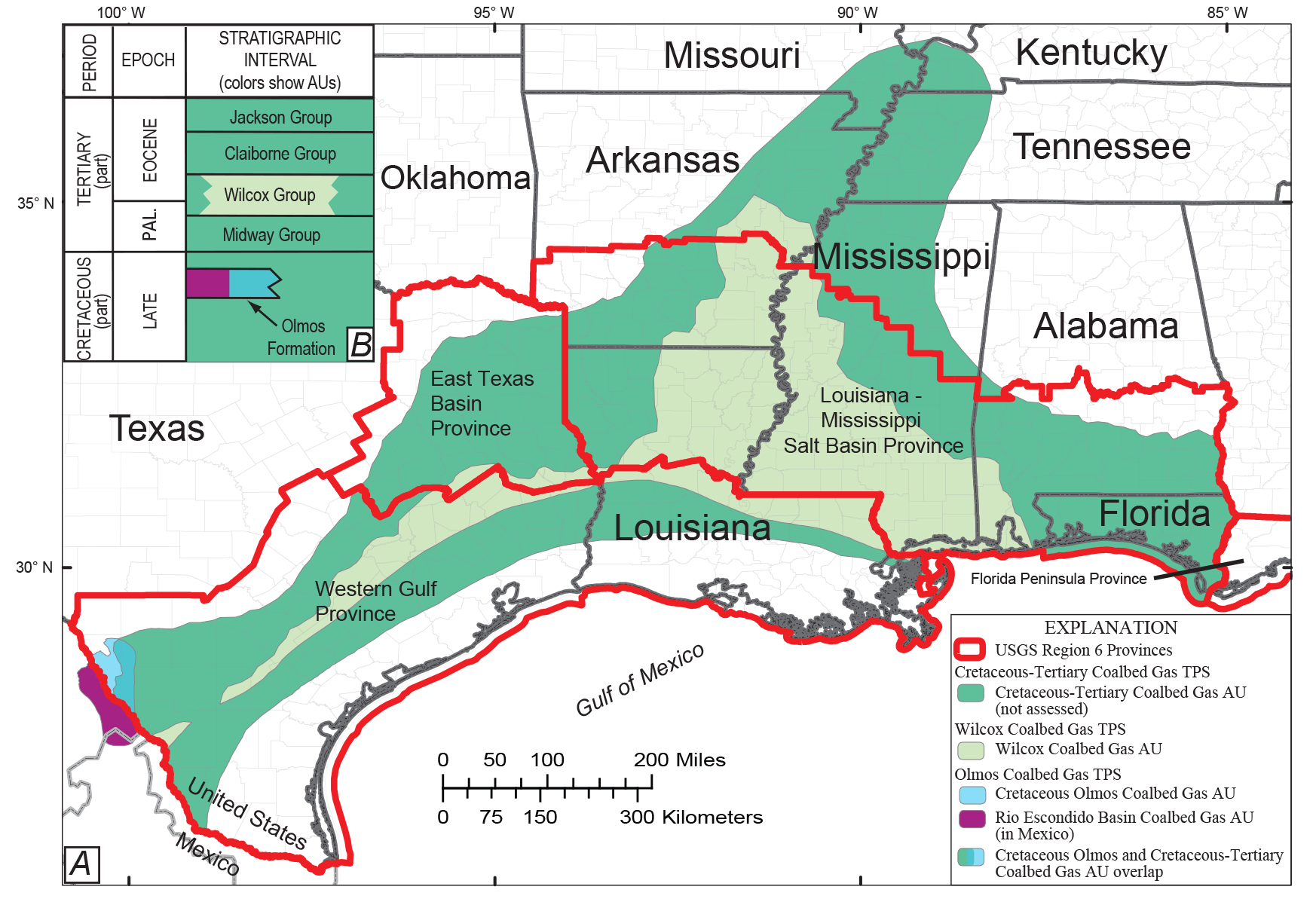
Map showing total petroleum system (TPS) and assessment unit (AU) boundaries for the Cretaceous–Tertiary continuous coalbed gas intervals in the Gulf of Mexico Coastal Plain and the Mississippi embayment as well as a stratigraphic section showing generalized stratigraphy of the region. A, Map showing TPS and AU boundaries. The U.S. Geological Survey (USGS) Region 6 Province boundaries (heavy red lines) are from U.S. Geological Survey National Oil and Gas Resource Assessment Team (1995). For a discussion of how the boundaries were drawn, see the sections “Olmos Coalbed Gas Total Petroleum System,” “Wilcox Coalbed Gas Total Petroleum System,” and “Cretaceous-Tertiary Coalbed Gas Total Petroleum System.” B, Inset generalized stratigraphic section of the coalbed gas assessment intervals in the TPSs and AUs mapped in figure 8A. Assessment interval colors match AU colors used in figure 8A. Figure modified from Warwick and others (2007a, figs. 1, 2). Abbreviation: PAL., Paleocene.
The Olmos Coalbed Gas TPS (504702), located in southern Texas and northeastern Mexico, was divided into two Upper Cretaceous AUs based on their geographic locations in Texas and Mexico: the Cretaceous Olmos Coalbed Gas AU (50470281) and the Rio Escondido Basin Olmos Coalbed Gas AU (53000281). The Wilcox Coalbed Gas TPS (504703), which contains the Wilcox Coalbed Gas AU (50470381), is the primary coalbed gas petroleum system in the gulf coast area in terms of total undiscovered coalbed gas resources. The Cretaceous-Tertiary Coalbed Gas TPS (504704) also defines one AU (Cretaceous-Tertiary Coalbed Gas AU 50470481; not assessed) that contains all other Cretaceous and Tertiary coal beds that are not part of the Cretaceous Olmos Coalbed Gas AU or the Wilcox Coalbed Gas AU.
The TPS and AU numbering system used in this report was established by the USGS to facilitate petroleum resource assessments (Klett and others, 2000). The unique numbers assigned to the three coalbed gas TPSs are 504702, 504703, and 504704 of which “5” denotes the world region (North America), “047” (Western Gulf) and “300” (Burgos Basin, for the Rio Escondido Basin Olmos Coalbed Gas AU [53000281]) denote the province, and “02,” “03,” and “04” denote the individual TPS. A review of the geologic model used to define the AUs is also presented below. Digital versions of the AU boundary lines are available for download at the following USGS website: https://certmapper.cr.usgs.gov/data/apps/noga-data/?provcode=5047.
In January 2007, the assessment team met in Denver to present to a review panel a thorough analysis of all the available geologic data, as well as petroleum exploration and development information for each AU. For each coalbed gas AU, EUR plots were made using available production data (Troy Cook, USGS, written commun., January 10, 2007). The result of the meeting was a consensus on the input-form data values (app. 1‒3) used for estimating the remaining hydrocarbon resources in each assessed AU. Appendixes 1‒3 contain estimates of (1) the total AU area in acres, (2) the AU cell area, in acres, that has potential for hydrocarbon accumulation, (3) the percentage of the AU area that is unexplored, and (4) the percentage of the AU area that is unexplored and has potential for hydrocarbon accumulations. The minimum total recovery for each cell in the AU used in this assessment was placed at 0.01 billion cubic feet of gas (BCFG). Other data compiled or calculated for each AU to aid in the final estimate of undiscovered resources include liquid-to-gas ratios, gas composition, drilling depths, exploration success ratios, and completion practices. The current assessment reflects estimates of undiscovered resources based only on vertical (nonhorizontal) drilling technology. Additionally, allocations of undiscovered resources were calculated for Federal, State, and private lands and for various ecosystem regions. All such data are available on the completed input data forms for the individual AUs (app. 1‒3). Table 1 lists the assessment results.
Table 1.
Results of an assessment of undiscovered, technically recoverable, continuous resources of coalbed gas in the Gulf of Mexico Coastal Plain for the four assessment units in this report.[Results shown are fully risked estimates. For gas accumulations, all liquids are included as natural gas liquids (NGLs). F95 represents a 95-percent chance of at least the amount tabulated; other fractiles are defined similarly. Fractiles are additive under the assumption of perfect positive correlation. Volume terms: BCFG, billion cubic feet of gas; MMBNGL, million barrels of natural gas liquids; MMBO, million barrels of oil. Other terms: AU, assessment unit; CBG, coalbed gas; NA, not applicable; TPS, total petroleum system; ‒, not quantitatively assessed. Table format modified from Warwick and others (2007a)]
Olmos Coalbed Gas Total Petroleum System (504702)
The coal-bearing Olmos Formation of the Navarro Group occurs within the Maverick Basin in Texas—as well as in the equivalent Rio Escondido Basin in Mexico—and is located in the northwestern part of the Rio Grande embayment of southern Texas and northeastern Mexico (figs. 1, 7B). This part of the Rio Grande embayment was folded and faulted during the Late Cretaceous to early Tertiary Laramide orogeny (Ewing, 1991, 1999). Significant structural features include the Chittim anticline in the northwest part of the basin and small-scale offsets (usually no more than a few feet) along numerous faults in the basin (Scott, 2003). The Olmos Formation thins and is truncated by erosion below the Midway and Wilcox Groups to the north near the present-day town of Uvalde (fig. 7B). The coal-bearing strata of the Olmos Formation are exposed near Eagle Pass in Texas and near Piedras Negras, Mexico (fig. 7B), where coal has been mined for more than a century (Evans, 1974; Verdugo and Ariciaga, 1991; Hook and others, 2011b). Olmos strata are also exposed in northern Mexico in the Rio Escondido Basin and various other basins outside the area (Weidie and others, 1972). In the Maverick Basin, the Olmos coal-bearing facies extend, from the outcrop, downdip towards the southeast for approximately 30 miles to where marine-dominated facies replace the terrestrial-dominated coal-bearing facies (Caffey, 1978; McBride and Caffey, 1979; Tyler and Ambrose, 1986; Ewing, 1999; Barker and others, 2002, 2003; Scott, 2003).
Previous studies have shown that the coals of the Olmos Formation are thin (generally <3 ft), are laterally discontinuous, and are host to numerous rock and volcanic ash partings (Vaughan, 1900; Evans, 1974; Caffey, 1978; McBride and Caffey, 1979; Flores Galicia, 1991; Verdugo and Ariciaga, 1991; Barker and others, 2002, 2003). Coals are most abundant in the lowermost sandstone-dominated part of the Olmos Formation where multiple coal beds typically occur within an approximately 50- to 100-ft-thick interval (fig. 9). Sandstone body geometries, abundant burrowing, and flaser-type bedding indicate a deltaic depositional origin for these sediments (Caffey, 1978; McBride and Caffey, 1979; Indest, 1982; Tyler and Ambrose, 1986; Mahmoud and others, 1999; Karlsen and others, 2002). Published coal quality data show that these coals have high ash yields (about 20 percent as-received basis), medium sulfur content (1.2 percent, as-received basis), and average calorific values of about 6,670 kilocalories per kilogram (kcal/kg) (moist, mineral-matter-free basis); these data indicate an apparent rank of high-volatile C bituminous (Evans, 1974; SanFilipo, 1999). Vitrinite reflectance (%Ro) values are as high as 0.6 %Ro (SanFilipo, 1999; Barker and others, 2002, 2003). Barker and others (2003) and Ewing (2003) estimated that about 6,500 to 7,500 ft of burial and subsequent uplift and erosion have occurred in this part of the basin. Values of 0.6 %Ro for Olmos coals are found near the outcrop (Barker and others, 2002, 2003). SanFilipo (1999) proposed the hypothetical location of rank isograds indicating a westward rank increase from lignite through bituminous (fig. 7B); Hackley and others (2005) concurred with the interpretation of Barker and others (2003) and Ewing (2003) in that increased burial depth is most likely responsible for the apparent rank elevation in southern Texas. Adsorption isotherm data indicate that the Olmos coals are gas saturated throughout the subsurface in the areas that have been drilled (Barker and others, 2002, 2003). Canister desorption data indicate the coals contain about 200–300 standard cubic feet per short ton (SCF/ton) (dry, ash-free basis) of gas in the area with the thickest coal beds west of the junction of the Maverick, Zavala, and Dimmit County boundaries (fig. 10) (Barker and others, 2002, 2003).
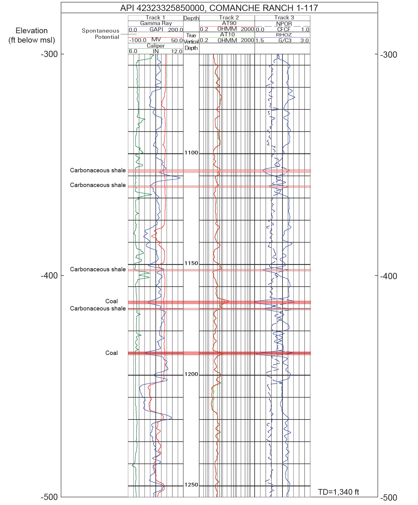
Example geophysical well log for the Cretaceous Olmos Coalbed Gas Assessment Unit from the Comanche Ranch 1-117 drill hole in Maverick County, Texas, showing coal and carbonaceous shale beds. Location of the well is shown in figure 10. Abbreviations: API, American Petroleum Institute; AT10, Array Induction Two Foot Resistivity A10; AT90, Array Induction Two Foot Resistivity A90; CFCF, cubic foot per cubic foot; ft, foot; GAPI, American Petroleum Institute gamma ray units; G/C3, gram per cubic centimeter; IN, inch; msl, mean sea level; MV, millivolts; NPOR, Enhanced Thermal Neutron Porosity; OHMM, ohmmeter; RHOZ, Standard Resolution Formation Density; TD, total depth.
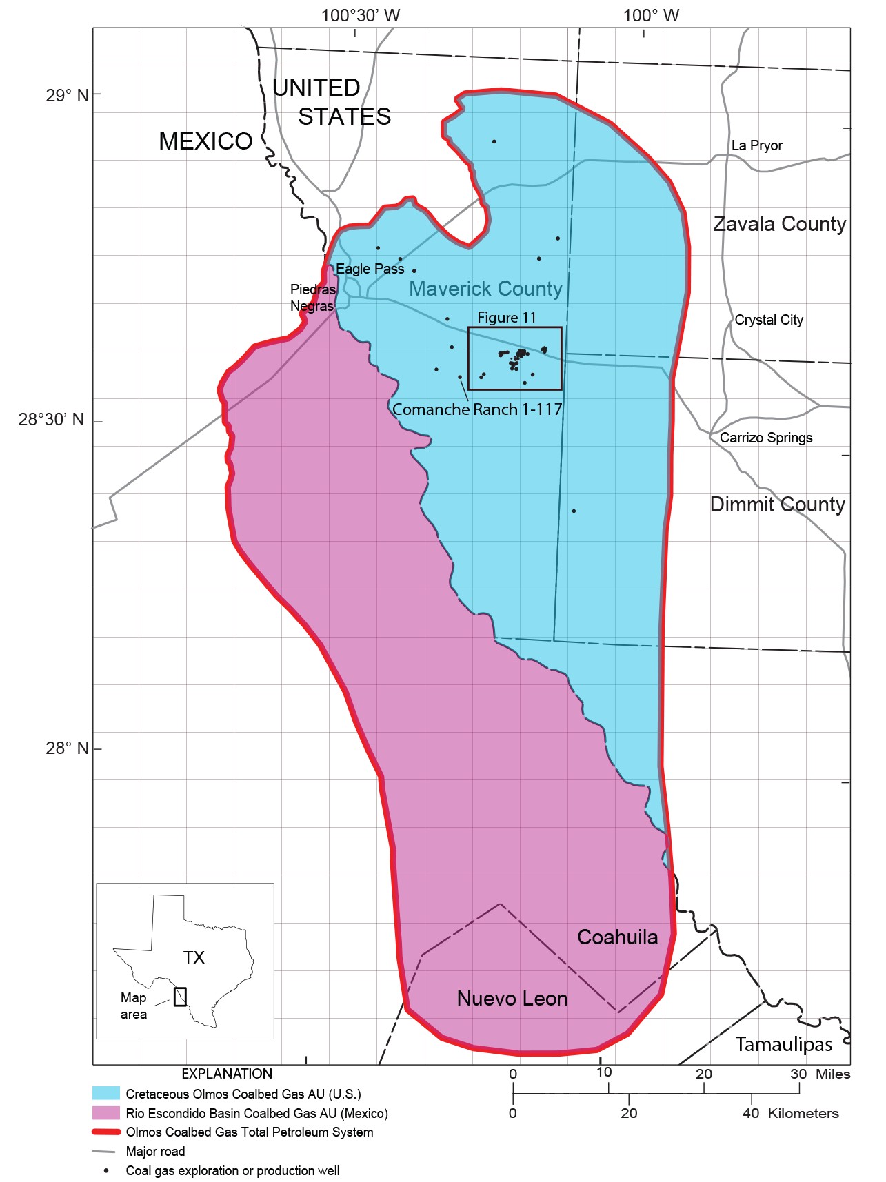
Map showing the extent of the Olmos Coalbed Gas Total Petroleum System in the United States and Mexico. Locations of 57 coalbed gas exploration and production wells are shown in the Cretaceous Olmos Coalbed Gas Assessment Unit. Inset box shows the location depicted in figure 11A. Each map grid cell represents an area of 5 square miles. Abbreviations: AU, assessment unit; TX, Texas; U.S., United States.
The Olmos Coalbed Gas TPS (504702) is confined to the coal-bearing part of the Olmos Formation and is outlined on figure 10. There is a limited amount of data published on the geochemical character and origin of the associated coalbed gas. Barker and others (2002, 2003) reported that desorbed gas from coal samples obtained in the basin is dominated by methane. Deuterium and carbon isotopic data from this methane indicate that the origin of the coalbed gas is biogenic to mixed biogenic and thermogenic. The mixed biogenic and thermogenic gas in the Olmos Coalbed Gas TPS could have formed in two main ways: (1) by biogenic gases (that were generated as the rocks cooled during uplift) mixing with the thermogenic coalbed gas (that was generated in situ during the time of maximum burial) or (2) by biogenic gases (that were generated in situ) mixing with thermogenic gases that migrated from depth (Barker and others, 2002, 2003). The Railroad Commission of Texas (2007) reported that few wells produced some gas condensate, so a maximum liquid/gas ratio (barrels of liquid/million cubic feet of gas [BLIQ/MMCFG]) value of 13 was used for the assessment input data forms; zero was used as the minimum value (app. 1).
Cretaceous Olmos Coalbed Gas Assessment Unit (50470281)
The Cretaceous Olmos Coalbed Gas AU (50470281) (fig. 10) extends southeast (downdip) from the Upper Cretaceous Olmos Formation of the Navarro Group outcrop (Warwick and others, 1997b) to the transition area where the coal-bearing facies changes into non-coal-bearing marine strata (fig. 7B). The southwestern boundary of the AU is the United States and Mexico border. The AU includes strata of the Olmos Formation (figs. 2, 4).
At the time of the assessment in early 2007, 57 exploration wells that tested for coalbed gas had been drilled or reentered in the Cretaceous Olmos Coalbed Gas AU part of the Maverick Basin (fig. 10). Thirty-nine (or 68 percent) of these wells were successful and have production data available from the IHS Energy Group (2005a, b) databases and the Railroad Commission of Texas (2007) (fig. 11). These wells were all part of the Sacatosa (CBM Olmos) Field (field no. 79451187) designated by the Railroad Commission of Texas (2007). The Sacatosa Field was the first CBM field to be recognized in Texas by the Railroad Commission (Barker and others, 2002, 2003).
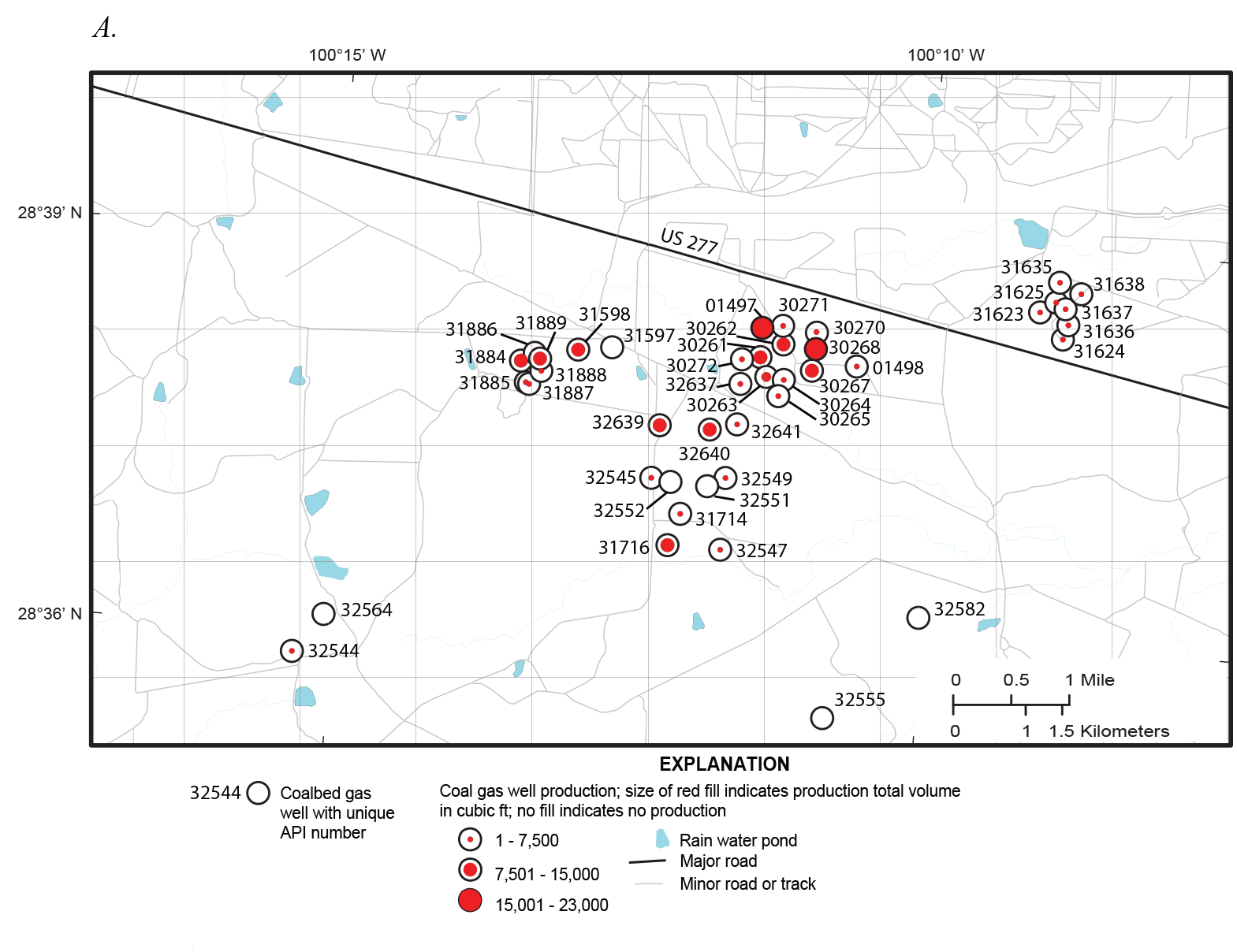
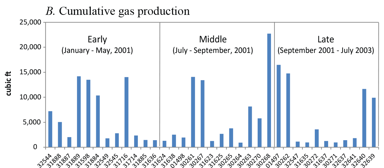
Map showing locations of wells in the Cretaceous Olmos Coalbed Gas Assessment Unit in southern Texas with known production data and a graph showing cumulative coalbed gas production for those wells. A, Map showing cumulative coalbed gas production for each well from 2001 to 2003, as indicated by the size of the red fill color. Empty circles are those wells with no production data available. For figure 11A and B, the numbers on the map and graph are part of the unique API number and should be prefixed by “42323” (State and County designations) to form the complete number. The area mapped in figure 11A is shown by the box in figure 10. Each map grid cell represents an area of 1 square mile. B, Graph showing cumulative coalbed gas production for each well; the wells are divided into three groups (early, middle, and late) based on their initial production date. The numbers on figure 11A correspond to the numbers on figure 11B, but wells that had no production are not included in figure 11B. Abbreviations: API, American Petroleum Institute; ft, foot.
Data from the 39 production wells were used to construct EUR plots for the Cretaceous Olmos Coalbed Gas AU (fig. 12A; Troy Cook, USGS, written commun., January 10, 2007). The median EUR value for these wells is about 8 million cubic feet (MMCF; fig. 12A). The EUR data were also divided into three groups based on early, middle, and late periods of production (fig. 12B). These data, when plotted by discovery thirds, show no major differences between the three groups; however, the middle third EUR values are generally less than the first and the last third datasets (fig. 12B). In general, EUR values from wells in the Cretaceous Olmos Coalbed Gas AU are very low when compared to values from other established CBM-producing basins (fig. 12C, D, E). Specifically, these EUR values are significantly lower than early (1987 to 1990) well data from the Raton Basin and early (1989 to 1995) well data from the Powder River Basin (fig. 12D, E). Gas contents measured by canister desorption for the coals of the Cretaceous Olmos Coalbed Gas AU are similar to those measured for the coals of the Raton Basin and greater than those of the Powder River Basin (see coal desorption data in Barker and others, 2002, 2003; Stricker and others, 2006; and Higley, 2007). Because limited production data were available for these coals, the Upper Cretaceous–Tertiary coals of the Raton Basin and the Powder River Basin (Flores, 2004; Higley, 2007) were used as analogs for assessment of the coals of the Cretaceous Olmos Coalbed Gas AU in Texas.
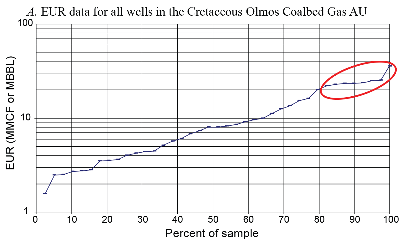
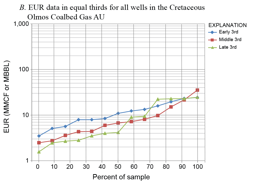
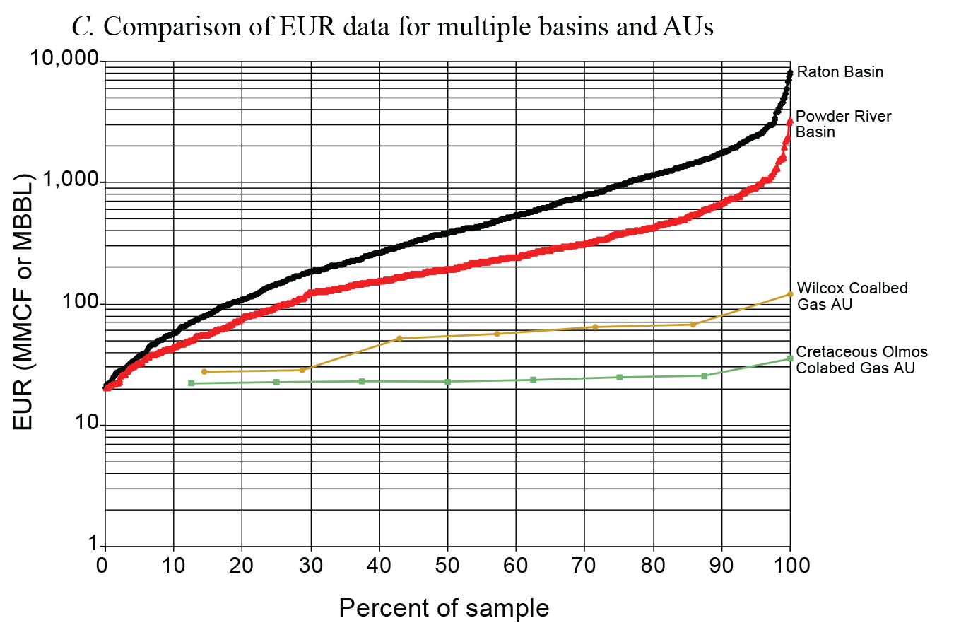
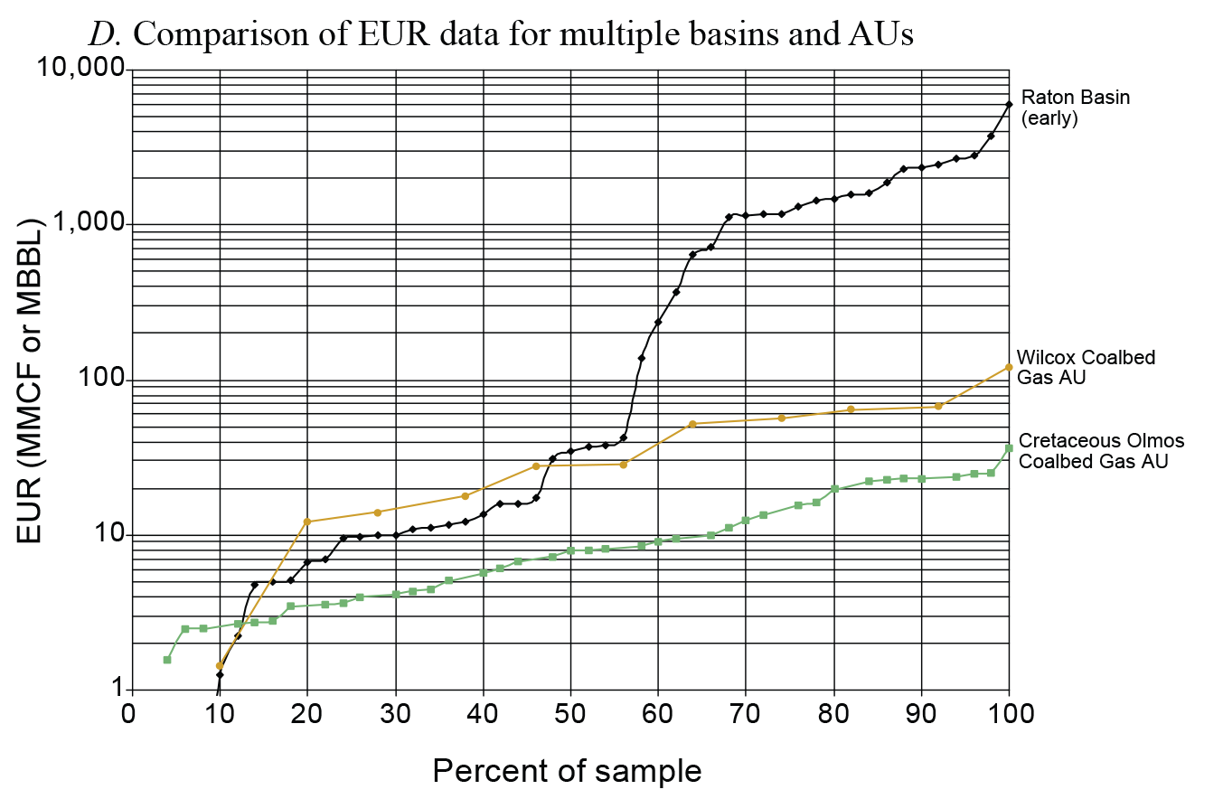

Estimated ultimate recovery (EUR) plots for the Cretaceous Olmos Coalbed Gas Assessment Unit (AU) and the Wilcox Coalbed Gas AU. All plots represent production prior to 2003 unless otherwise specified. A, The EUR data distribution for all wells in the Cretaceous Olmos Coalbed Gas AU. No minimum EUR cutoff is used for the data. The red oval indicates data shown on figure 12C. B, Early, middle, and late EUR data distribution thirds for wells in the Cretaceous Olmos Coalbed Gas AU; 0.01 billion cubic feet (BCFG) is used as the minimum cutoff for the data. C, The EUR data for Cretaceous Olmos Coalbed Gas AU wells compared to EUR data for wells from the Wilcox Coalbed Gas AU, as well as the Raton Basin and the Powder River Basin; 0.02 BCFG is used as the minimum cutoff for the data. D, The EUR data from the Cretaceous Olmos Coalbed Gas AU and Wilcox Coalbed Gas AU compared to early EUR data from the Raton Basin. Raton Basin (early) data ranges from 1987 to 1990 and is a partial subset of the Raton Basin data shown in figure 12C; no minimum EUR cutoff is used for the data. E, The EUR data from the Cretaceous Olmos Coalbed Gas AU and Wilcox Coalbed Gas AU compared to EUR data from the Powder River Basin. Powder River Basin (early) data ranges from 1989 to 1995 and is a subset of the Powder River Basin dataset; no minimum EUR cutoff is used for the data. See figure 1A for the location of the Raton and Powder River Basins and Flores (2004) and Higley (2007) for a discussion of the geology of these basins. All plots are modified from Troy Cook (U.S. Geological Survey, written commun., January 10, 2007). Abbreviations: MMCF, million cubic feet; MBBL, thousand barrels.
Scott (2003) explained that the operating company that managed most of the producing coalbed gas wells in the Maverick Basin experienced problems producing gas. These difficulties may have been a product of the completion and stimulation methods employed by the operating companies rather than an inability of the coals to produce gas at rates found in other basins (Scott, 2003). However, the low production and EUR values strongly influenced the assessment results of the Cretaceous Olmos Coalbed Gas AU.
The assessment results for the Cretaceous Olmos Coalbed Gas AU are listed in table 1. A mean of 75 BCFG of undiscovered, technically recoverable, continuous natural gas was estimated for the AU. The AU form input parameters are listed in appendix 1. The assessment results reflect a mode value of 33 percent of the AU area having the greatest potential to be developed as a fairway for the addition of new reserves; 25 percent of that value (8 percent) has the greatest potential to have EUR recoveries greater than 0.01 BCFG. This reflects a future success ratio of 25 percent for the total AU area (mode; app. 1).
Rio Escondido Basin Olmos Coalbed Gas Assessment Unit (53000281)
The Rio Escondido Basin Olmos Coalbed Gas AU (53000281) (fig. 10) extends from the outcrop of the Olmos Formation in Mexico south (downdip) to the transition area of the coal-bearing facies into marine non-coal-bearing rocks. The northern boundary of the AU is the United States and Mexico border. The AU also includes strata of the Upper Cretaceous Olmos Formation of the Navarro Group (figs. 2, 4). The Rio Escondido Basin Olmos Coalbed Gas AU is a continuation of the Cretaceous Olmos Coalbed Gas AU (50470281) and is renamed because of its location in Mexico.
Very few data are available on the character of the gas associated with the Olmos Formation coals in the Rio Escondido Basin. Several studies have discussed the potential for CBM development in the Rio Escondido and adjacent basins in Mexico (Eguiluz de Antuñano, 2001; Eguiluz de Antuñano and Amezcua Torres, 2003; Corona-Esquivel and others, 2006; Gentzis and others, 2006), but no detailed data are available on the gas content of Rio Escondido coals. However, coalbed gas studies in the Maverick Basin in Texas (Barker and others 2002, 2003; Scott, 2003) and reports of coalbed gas in mines in the Sabinas and Rio Escondido Basins (Schwoebel and others, 1993; Schwochow, 1997; Santillán-González, 2003; U.S. Environmental Protection Agency Coalbed Methane Outreach Program, 2015) suggest that coalbed gas may be present throughout the Rio Escondido Basin in Mexico.
Because no detailed coalbed gas geochemical or production data are available for the Rio Escondido Basin Olmos Coalbed Gas AU, data from the Cretaceous Olmos Coalbed Gas AU were used for the Rio Escondido Basin Olmos Coalbed Gas AU assessment data forms (app. 2). The only difference between the two AUs is that the Rio Escondido Basin Olmos Coalbed Gas AU is geographically larger and therefore its resource estimate is larger than the Cretaceous Olmos Coalbed Gas AU.
The assessment results for the Rio Escondido Basin Olmos Coalbed Gas AU are listed in table 1. A mean of 123 BCFG of undiscovered, technically recoverable, continuous natural gas was estimated for the AU. The AU form input parameters are listed in appendix 2. The assessment results reflect a mode value of 45 percent of the AU area having the greatest potential to be developed as a fairway for the addition of new reserves; 25 percent of that value (11 percent) has the greatest potential to have EUR recoveries greater than 0.01 BCFG. This reflects a future success ratio of 28 percent (mode; app. 2).
Wilcox Coalbed Gas Total Petroleum System (504703)
The Wilcox Coalbed Gas TPS (504703) is located in the portion of the Wilcox Group (fig. 8A) that contains coal-bearing strata (fig. 4). The coal-bearing facies of the Wilcox Group extends across the entire onshore part of the Gulf of Mexico Coastal Plain and generally does not extend basinward of the Lower Cretaceous shelf margin (figs. 6, 8). Beyond the shelf margin, Wilcox Group strata contain marine facies; however, few wells have penetrated these strata basinward of the Lower Cretaceous shelf margin and the full downdip extent of Wilcox Group coal-bearing strata is not well known. Regional cross sections that show the downdip character and extent of the Wilcox Group in Florida, Alabama, and Mississippi have been published by Maher and Applin (1968) and Williams (1969). Similar cross sections have been published for other regions of the Gulf of Mexico Coastal Plain; for Louisiana, refer to Bebout and Gutiérrez (1982, 1983), Eversull (1984), and Glawe and Echols (1997); for the Arkansas, Louisiana, and Texas border area, refer to Morton and others (1990) and Stoudt and others (1990a, b); and for Texas, refer to Dodge and Posey (1981) and Galloway and others (1994). The downdip transition from Wilcox Group deltaic (coal-bearing) to marine facies in Texas is well depicted on cross sections by Galloway and others (1994) and Xue and Galloway (1995).
Wilcox Group coal-bearing sediments in the northern part of the Gulf of Mexico Coastal Plain consist of interbedded sandstone, siltstone, claystone, coal, and limestone beds. Depositional settings for these strata have been interpreted to be prograding fluvial-deltaic systems with alluvial plain and deltaic peat mire environments (Murray, 1961; Fisher and McGowen, 1967; Galloway, 1968; Cleaves, 1980; Coates and others, 1980; Ayers and Lewis, 1985; Kaiser, 1990; Breyer, 1991; Galloway and others, 1991, 2000; Tye and others, 1991; Mancini and others, 1993; Glawe, 1995; Kinsland and others, 2003; Kull and Kinsland, 2006). Wilcox Group coal rank ranges from lignite at the outcrop to high volatile C bituminous at depths of about 5,500 ft (Tewalt, 1986; Mukhopadhyay, 1989; Warwick and others, 2006, 2008; Pierce and others, 2011).
The coal-bearing part of the Wilcox Group ranges from about 500 to 1,000 ft thick near the outcrop and thickens to about 2,000 to 4,000 ft near the Lower Cretaceous shelf margin (fig. 6). In general, Wilcox Group coal beds can be grouped into lower, middle, and upper coal zones; in east-central Texas, these units are referred to as the Hooper, Simsboro, and Calvert Bluff Formations, respectively, with the Calvert Bluff being the primary coal-bearing unit (fig. 4). In northern Louisiana, individual coal beds reach a maximum thickness of about 20 ft and the thickest coal beds tend to be in the lower Wilcox Group coal zone. Cumulative coal thickness for all three zones can exceed 98 ft. Examples of Louisiana well-log stratigraphy and coal intervals are shown on figure 13 and have been documented by Echols (2001), Breland and Warwick (2005), and Warwick and others (2006, 2008).
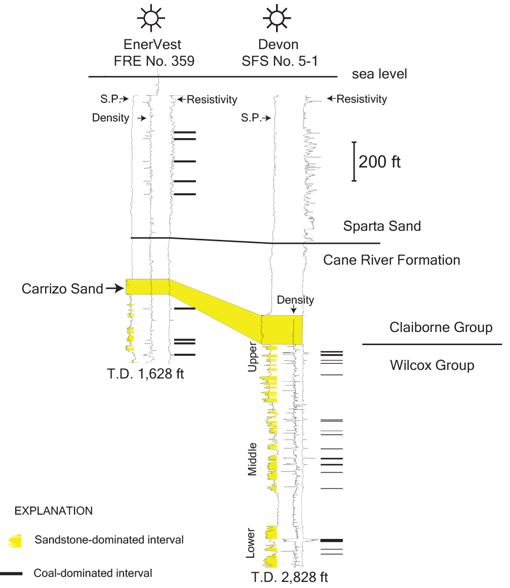
Generalized stratigraphic column of northern Louisiana showing selected geophysical (spontaneous potential, density, and resistivity) logs for coalbed gas wells and coal beds in the Wilcox Group (Paleocene–Eocene) and Sparta Sand (Claiborne Group, Eocene). Well locations are shown in figure 14. Modified from Hackley and others (2007a), Warwick and others (2008), and McIntosh and others (2010). Abbreviations: S.P., spontaneous potential; T.D., total depth.
Numerous studies have discussed the character, distribution, and thickness of coal beds in Wilcox Group strata of the gulf coast region; many of these reports are listed in Doney (1986), Tewalt and others (1990), and Hook and others (2011a); the two older reports focus on near-surface coal as a minable resource. Some important older Wilcox Group coal reports include Brown (1907), Williamson (1976), Cleaves (1980), Mancini (1983), and Tolson (1985), all of which described the lignite deposits of western Alabama and Mississippi. Louisiana coal deposits have been described by Meagher and Aycock (1942), Roland and others (1976), Coates and others (1980), Luppens (1986), and Williamson (1986). Texas coal deposits have been described by Phillips (1902), Fisher (1963), Kaiser (1974, 1986, 1990), Ayers and Lewis (1985), Ayers and Kaiser (1986), Ayers and others (1986), Finkelman and Casagrande (1986), Kaiser and others (1986), Breyer (1991), and Warwick and others (2011). More recent reports have focused on Wilcox Group CBM potential and these include reports by Echols (1995, 2001), Basin Research Institute (1999), SanFilipo (1999), Scott (1999, 2000), Barker and others (2000), Griffiths and Pilcher (2000), SanFilipo and others (2000a, b), Scott and Tyler (2000), Warwick and others (2000a, b, 2002, 2008), Breland and John (2002), Ayers and others (2005), McVay and others (2005), and Hackley and others (2007a).
The potential for Wilcox Group coalbed gas was first discussed based on coalbed gas shows obtained from a USGS test well drilled in Panola County, Texas (fig. 14) (Warwick and others, 1999, 2000a, b, 2002, 2005). In this well, at a depth of 355 ft, an 18-ft-thick lower Wilcox Group coal bed had an average raw (as-determined) gas content of 7 SCF/ton. A second Panola County well—drilled by the USGS—contained no measurable coalbed gas. Subsequent work in Texas, Louisiana, and Mississippi has shown that Wilcox Group coalbed gas content increases to over 300 SCF/ton at depths greater than 3,000 ft (Griffiths and Pilcher, 2000; Warwick and others, 2004a, b, 2006, 2008; Ayers and others, 2005; McVay and others, 2005; Hackley and others, 2007a, b).
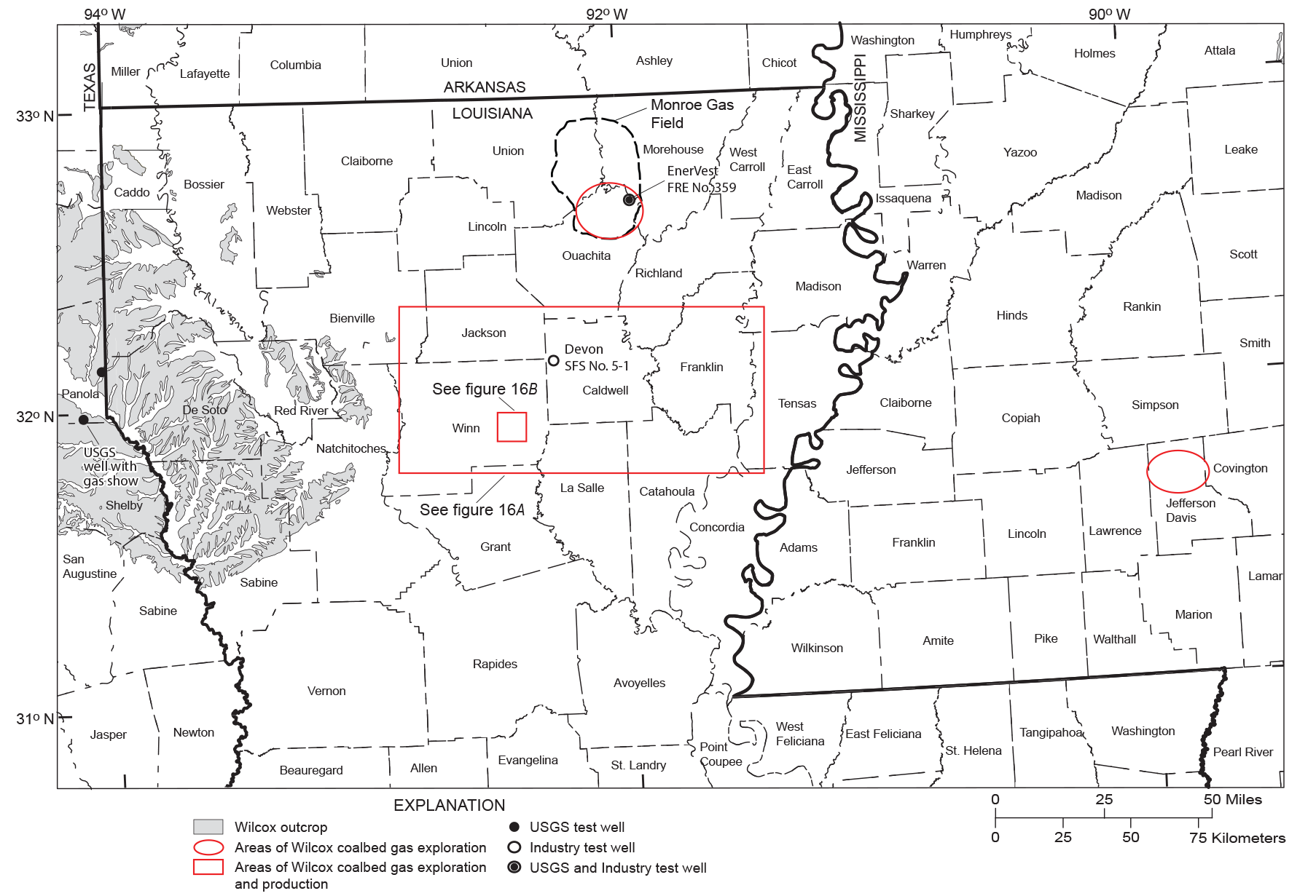
Index map showing the locations of coalbed gas (methane) exploration and production activity in northern Louisiana and central Mississippi within the Wilcox Coalbed Gas TPS. Included are two USGS wells (western edge of map extent) and the two wells shown in figure 13. Outlines of the figure 16 map area extents are indicated by red boxes. Abbreviations: TPS, total petroleum system; USGS, U.S. Geological Survey.
Reviews of CBM exploration activity in northern Louisiana are presented in Echols (2001), Warwick and others (2002, 2008), and Breland and Warwick (2005). At the time of the assessment in 2007 (Warwick and others, 2007a), approximately 50 wells had been drilled in northern Louisiana, specifically for coalbed gas exploration or production. Public data from 19 wells completed in Wilcox Group coal zones in north-central Louisiana since 2001 indicate an initial production range of 7,000 to 229,000 cubic ft of gas per day and as many as 550 barrels of water per day (Breland and Warwick, 2005). Cumulative production (January 2001 through December 2006) from these wells was approximately 878 MMCF (Warwick and others, 2008).
Production activities in the study area have been hampered mostly because of the lack of a suitable completion method that will work in the Wilcox Group coals. The problem is related to high water production, which is probably derived from associated Wilcox Group sand bodies. These highly permeable Wilcox Group sands appear to be in hydrologic communication with the coals. Several operators have seen increased water production even in short-radius horizontal wells (single lateral, open hole, and unstimulated). They attribute this to the “shrinking” of the coal and expansion of cleat and fracture networks into the overlying and underlying water-bearing sands. In an attempt to “bypass” these water-bearing sands, most prospects are trying to locate a Wilcox Group coal bed bound by thick shale seals, which would serve as a barrier to reduce or eliminate water production (Richard T. Lewis, Penn Virginia Oil & Gas Corporation, written commun., December 13, 2007).
Coalbed gas exploration has occurred in central Mississippi (fig. 14). Although most data are confidential, Penn Virginia Oil & Gas Corporation provided some of the data that are contained in Warwick and others (2008). The Wilcox coal-bearing stratigraphy and structural settings of Mississippi are similar to those described above for north-central Louisiana.
In the coalbed gas producing area of northern Louisiana (fig. 14), the amount of formation water in the Wilcox Group is influenced by the presence of salt structures (Hanor and Sassen, 1990; Huff and Hanor, 1997; Hanor and McIntosh, 2007; McIntosh and others, 2010). Lower Tertiary aquifers (Wilcox Group, Sparta Sand, and Cockfield Formation) are separated by confining units (Midway Group, Cane River Formation, Cook Mountain Formation, Jackson Group, and Vicksburg Group) (fig. 15). There are also unexposed Late Cretaceous intrusive igneous bodies in areas of northeastern Louisiana, west-central Mississippi, and southeastern Arkansas (fig. 1B) (Byerly, 1991; Coleman, 1991, 2008; Ewing and Lopez, 1991). These igneous bodies “may have promoted hydrothermal circulation and upward transfer of solutes during late Mesozoic and early Cenozoic” (Heydari and others, 1997, p. 201) and may have locally contributed to Wilcox Group strata thermally maturing during the early Paleocene.
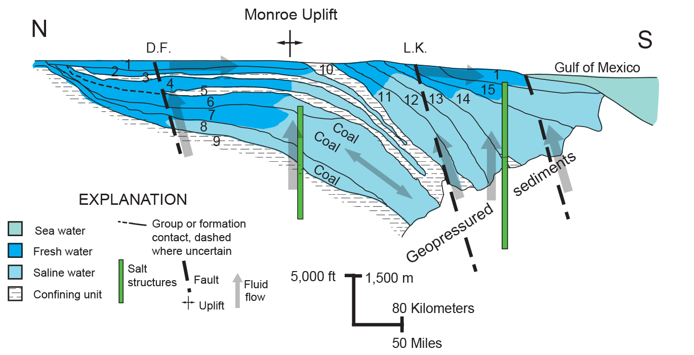
Generalized north-to-south structural cross section along the Mississippi embayment showing geology, hydrology, and structural features. See figure 1B for the north (N) and south (S) endpoints of this section. The position of salt structures is greatly generalized. Note that coal-bearing aquifer systems are filled with saline water derived from groundwater interaction with salt diapirs. Geopressured sediments are found at depth. Figure modified from Bebout and Gutiérrez (1983), Hanor and Sassen (1990), Williamson and others (1990), Huff and Hanor (1997), and Warwick and others (2008). Numbers on the figure correspond to the following geologic units: 1, Holocene to Pleistocene sediments; 2, Cockfield Formation; 3, Cook Mountain Formation; 4, Sparta Sand; 5, Cane River Formation; 6, Wilcox Group, upper; 7. Wilcox Group, middle; 8, Wilcox Group, lower; 9, Midway Group confining unit; 10, Jackson Group and Vicksburg Group; 11, Frio Formation and Anahuac Formation; 12, Miocene sediments, lower; 13, Miocene sediments, middle; 14, Miocene sediments, upper; 15, Pliocene sediments. Abbreviations: D.F., approximate location of deformation front shown on figure 1B; L.K., approximate location of the Lower Cretaceous shelf margin shown on figure 1B; ft, foot; m, meter.
Molecular and isotopic data from coalbed gas samples collected in northern Louisiana indicate that Wilcox Group coalbed gases were derived from bacterial reduction of carbon dioxide (CO2) (Warwick, 2004a; Breland and Warwick, 2005; Warwick and others, 2005, 2006, 2008; Hackley and others, 2007a; McIntosh and others, 2007a, b, 2010). The coal-bearing formation water in the coalbed gas productive areas in northern Louisiana is enriched in Na+ and Cl− from the dissolution of salt diapirs and other salt structures in the area (fig. 15) (Pettijohn, 1996; Huff and Hanor, 1997; McIntosh and others, 2010). Groundwater flow around these salt structures has created a suitable geochemical environment for the bacterial reduction of CO2 and the formation of methane in the Wilcox coal beds (McIntosh and others, 2007a, b; Warwick and others, 2008). The depth and formation-water geochemistry of Wilcox Group coal-bearing areas appear to be the major controlling factors that define potential CBM exploration and production fairways in the northern part of the Gulf of Mexico Coastal Plain.
Wilcox Coalbed Gas Assessment Unit (50470381)
The boundary of the Wilcox Coalbed Gas AU (50470381) was defined by using the geologic parameters that influence the distribution of the coalbed gas in the AU (fig. 8). Because Louisiana coalbed gas production in this AU appears to be enhanced by the presence of saline water (Warwick and others, 2008; McIntosh and others, 2010), the northwestern, northern, and northeastern (updip) boundaries of the AU are defined by the approximate position of the 10,000 milligrams per liter (mg/L) total dissolved solids (TDS) line drawn to characterize groundwater in the Wilcox Group (see Pettijohn, 1996). The southern (downdip) boundary of the AU is defined by the Lower Cretaceous shelf margin of Galloway and others (2000) that approximates the downdip extent of the Wilcox Group coal-bearing strata. The Lower Cretaceous shelf margin roughly parallels the contour line of 6,000 ft depth to the top of Wilcox Group (see Barker and others, 2000). This contour line generally denotes a depth cutoff for coalbed gas production due to increased reservoir pressure and decreased permeability (U.S. Geological Survey National Oil and Gas Resource Assessment Team, 1995). The southeastern boundary of the AU in southern Mississippi and northwestern Florida is the State/Federal water boundary. The AU only includes strata of the Paleocene–Eocene Wilcox Group (fig. 8).
At the time of the 2007 assessment, 53 wells had been drilled in northern Louisiana for coalbed gas (fig. 16). Production data from IHS Energy Group (2005a) and the Louisiana Department of Natural Resources (2007) were available from 19 of these wells; however, only 11 wells have sufficient production volumes that could be used to construct EUR plots for the Wilcox Coalbed Gas AU (fig. 12D–E; Troy Cook, USGS, written commun., January 10, 2007). Because of the small number of Wilcox Group coalbed gas production wells, the EUR data could not be sorted based on early, middle, and late periods of production; therefore, this line on the assessment form is blank (app. 3). The EUR data from the Cretaceous Olmos Coalbed Gas AU and Wilcox Coalbed Gas AU were compared to similar datasets from the Raton and Powder River Basins (fig. 12C–E). Because limited production data were available for the Wilcox Group coals, the Upper Cretaceous–Tertiary coals of the Raton Basin and the Powder River Basin (Flores, 2004; Higley, 2007) were used as analogs for assessment of the Wilcox Group coals in the gulf coastal region.
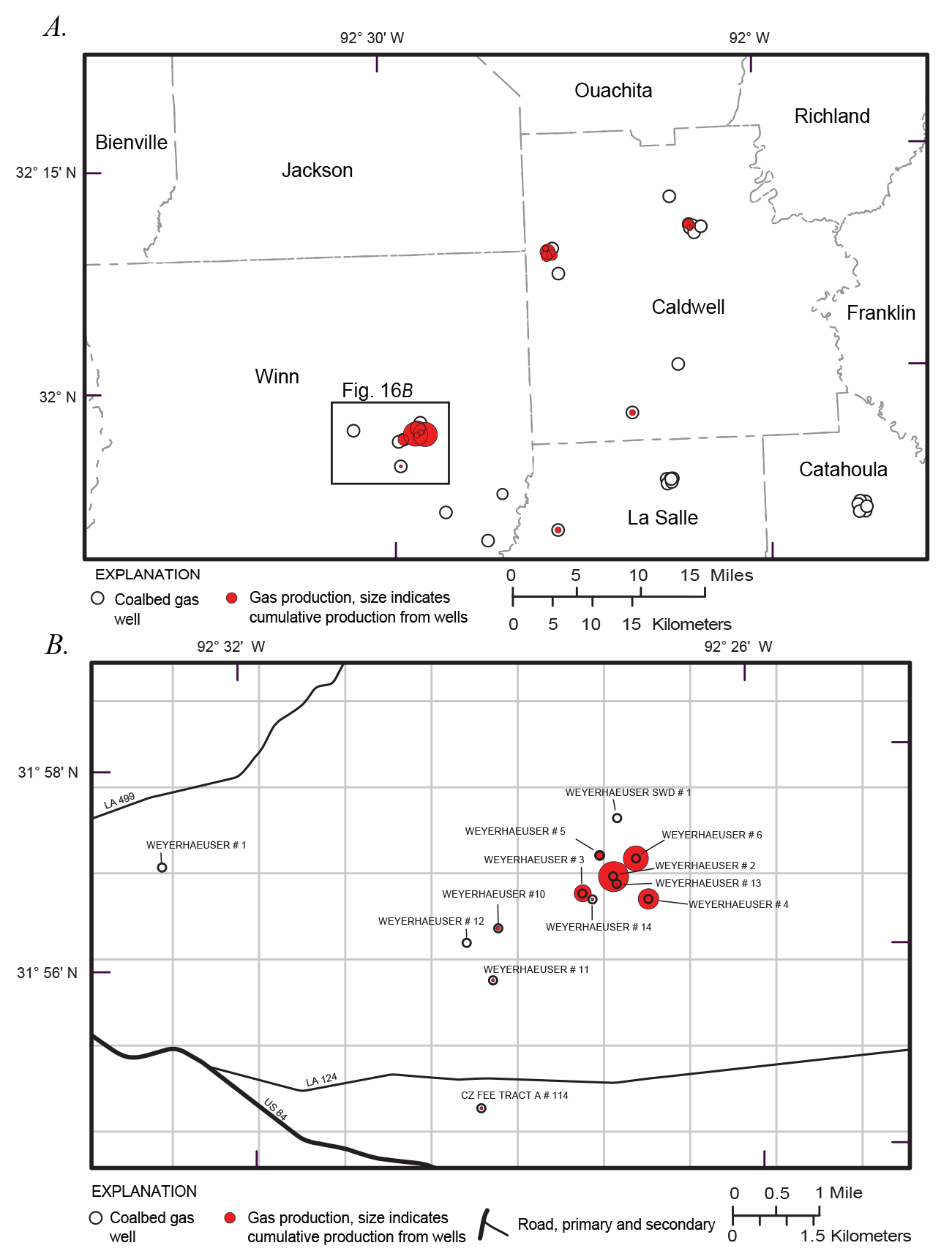
Index maps showing the locations of coalbed gas exploration activity in northern Louisiana. A, Coalbed gas exploration and production wells in northern Louisiana. B, Coalbed gas exploration and production wells in Winn Parish. Each map grid cell represents an area of 1 square mile. The areas mapped in figure 16A and B are shown in figure 14. For figure 16A and B, relative well production is indicated by the size of the red fill.
The EUR data from the Wilcox Coalbed Gas AU in the Gulf of Mexico Coastal Plain (fig. 12C–E) indicate that the expected gas production from Wilcox Group coals is approximately three times that of the Cretaceous Olmos Formation coals of southern Texas. As discussed in the Cretaceous Olmos Coalbed Gas AU section above, coalbed gas production from each AU is expected to be less than that of similar coals in the Raton and Powder River Basins. It is interesting to note that the EUR values graphed for the first 45 percent of the sample on figure 12D for wells in the Wilcox Coalbed Gas AU are slightly better than the values for the first 45 percent of the Raton Basin (early) coalbed gas production wells (fig. 12D). However, from 45 to 100 percent the of the data graphed, the Raton Basin wells have EUR values that are significantly greater than those for the Cretaceous Olmos Coalbed Gas AU and Wilcox Coalbed Gas AU coals. The rapid increase in EUR values for the Raton Basin probably indicates improvements in completion technologies or the discovery of high-producing areas (sweet spots). This disparity suggests that similar improvements in completion technologies or sweet spot discoveries may not have been made for the Cretaceous Olmos Coalbed Gas AU and Wilcox Coalbed Gas AU production areas.
The assessment results for the Wilcox Coalbed Gas AU are listed in table 1. A mean of 3,861 BCFG of undiscovered, technically recoverable, continuous natural gas was estimated for the AU. The AU form input parameters are listed in appendix 3. The geochemical parameters for the gas used on the assessment form were derived from gas geochemical data presented by Warwick and others (2005, 2006, 2008), Hackley and others (2007a), and McIntosh and others (2007a, b, 2010). The assessment results reflect a mode value of 15 percent of the AU area having the greatest potential to be developed as a fairway for the addition of new reserves; 30 percent of that value (4.5 percent) has the greatest potential to have EUR recoveries greater than 0.01 BCFG. This reflects a future success ratio of 30 percent (mode; app. 3).
Cretaceous-Tertiary Coalbed Gas Total Petroleum System (504704)
The Cretaceous-Tertiary Coalbed Gas TPS (504704) and its corresponding AU include all of the potentially gas-bearing Cretaceous and Tertiary coal beds in the onshore portion of the U.S. Gulf of Mexico Coastal Plain that were not included and assessed in the Cretaceous Olmos Coalbed Gas AU or the Wilcox Coalbed Gas AU (fig. 8). Besides the Cretaceous Olmos Coalbed Gas AU and Wilcox Coalbed Gas AU coals described above, no other coalbed gas production has been reported for gulf coast coals. However, since there is potential for some coalbed gas to be associated with coals outside of the assessed Wilcox Coalbed Gas AU and Cretaceous Olmos Coalbed Gas AU intervals, the Cretaceous-Tertiary Coalbed Gas AU (50470481) (fig. 8) was defined. This AU was not assessed by the USGS in 2007 because of the general lack of data on some coal intervals and the relatively low potential for these coals to contain economic quantities of coalbed gas, given the prices and technology available in 2007. These conditions continue to exist today. The identification of this AU acknowledges that there is hypothetical potential for coalbed gas to occur within the AU boundaries. Most of the coals in the Cretaceous-Tertiary Coalbed Gas AU are lignitic and occur in freshwater-bearing intervals in the gulf coast area where biogenic coalbed gas production appears to be minimal (Warwick and others, 2008; McIntosh and others, 2010; Aubourg, 2011; Hackley and others, 2011a, b; Hook and others, 2011c, d; Hook and Warwick, 2011; Karlsen and others, 2011).
Cretaceous Coal Occurrences
A few Cretaceous coal occurrences have been reported in the northern Gulf of Mexico Coastal Plain area; however, little is known about their subsurface lateral extent and gas potential. Lower Cretaceous coal beds are known to occur in Arkansas in the Hosston Formation (Valanginian to Aptian in age) or in the lower part of the Trinity Group (Aptian to Albian in age) (fig. 2) where drill records indicate coal beds greater than 10 ft thick occur at depths of 3,000 to 3,100 ft (Warwick and others, 2004b; Hackley and others, 2006a, 2011a). Coal rank ranges from subbituminous C to subbituminous A to high volatile bituminous C (Hackley and others, 2006a, 2011a). Other coal occurrences within the Hosston Formation in Texas, Louisiana, and Mississippi have also been reported (Imlay, 1945; Scherer, 1980; Mitchell-Tapping, 1997; Jim York, EnerVest Operating LLC, oral commun., 2003). Although coal beds less than 1.5 ft thick in the Upper Cretaceous Tuscaloosa and Eutaw Formations (fig. 2) have been reported to occur in outcrop areas in northwestern Alabama and northeastern Mississippi by Brown (1907), Monroe and others (1946), and Vestal (1947), the downdip extent of these coal occurrences is unknown. In addition, lignite beds are also known to occur in the stratigraphically equivalent Upper Cretaceous Tokio Formation in southwestern Arkansas (Dolloff and others, 1967; Schrader and Scheiderer, 2003) and in the slightly older Woodbine Formation (fig. 2) in Texas (McGowen and others, 1967). Little is known about the thickness and lateral continuity and downdip extent of these coal occurrences.
In the northern part of the Mississippi embayment—primarily in southern-most Illinois and in western Kentucky and Tennessee—lignite beds occur in the Upper Cretaceous McNairy Sand (figs. 3, 4) (Stephenson, 1914; Roberts, 1945; Pryor, 1960; Olive, 1966, 1969, 1980; Russell and Parks, 1975; Olive and McDowell, 1986; Hower and others, 1990). The McNairy deltaic coal-bearing facies transition southward into marine sand, shale, and carbonates of the Nacatoch Sand in Arkansas, Louisiana, and Texas (McGowen and Lopez, 1983) and the Ripley Formation in Mississippi and Alabama (Russell and Parks, 1975; Mancini and others, 1996). In outcrop, the McNairy Sand is reported to be 300 to 350 ft thick, is disconformable over Paleozoic rocks in western Kentucky, and is disconformably overlain by Tertiary-aged strata in western Tennessee (Russell and Parks, 1975; Olive, 1980). Pryor (1960) reported that the McNairy Sand thickens to greater than 600 ft in the subsurface near the Tennessee, Missouri, and Arkansas border. Wells that penetrate the McNairy in this area show the top of the formation at approximately 2,000 ft below the surface (Hosman and Weiss, 1991). Well log data from studies such as Oman (1986), Parks and Carmichael (1990), and Martin (2008) indicate that lignite beds are present in stratigraphic test wells that were drilled beneath the alluvium of the Mississippi embayment and into Cretaceous and Tertiary units.
The McNairy Sand is primarily composed of light- to dark-gray, fine- to medium-grained, unconsolidated sand that weathers to yellow or reddish brown (Olive, 1980). Sands are interbedded with gray, black, or brown clays with minor chert gravels and silts and lignite (Olive, 1980; Olive and McDowell, 1986; Hackley and others, 2006b, 2011a). Lignite in the McNairy Sand occurs in highly discontinuous and thin (<1.5 ft thick) beds (Olive, 1980) and is present in the subsurface in western Kentucky (Hower and others, 1990). In addition to discrete lignite beds, lignitic clays are common in the McNairy Sand (Roberts, 1945; Pryor, 1960; Olive, 1966, 1969, 1980; Russell and Parks, 1975; Hackley and others, 2006b, 2011a). Analysis of a sample from an outcrop in western Kentucky indicates that McNairy Sand lignite (carbonaceous shale at this location) has a 11.16 percent (as-determined) moisture content and a 52.96 percent (dry basis) ash yield (Hower and others, 1990). A huminite reflectance value of 0.28 percent was also reported (Hower and others, 1990).
Mesozoic igneous bodies intruded into the Mississippi embayment area of eastern Arkansas and Mississippi; this likely elevated the thermal maturity of Paleozoic source rocks of the Ouachita and Black Warrior Basins in the area (Coleman 1991, 2008). This igneous sequence is composed of bodies with ages of Late Cretaceous, Middle Jurassic, early Paleozoic, and Neoproterozoic. The Late Cretaceous igneous sequence lies between sandstones immediately below the Austin Group (and equivalent Eutaw Formation) and above sandstones that are correlated with the Tuscaloosa Formation in nearby wells. Radiometric ages for this sequence range from 81 to 66 million years ago (mega-annum, Ma) with a mean of 77 Ma (Baksi, 1997). While the lithostratigraphy succession and correlation of the Late Cretaceous portion of the lower Mississippi embayment is not well documented, this age places the Late Cretaceous igneous sequence more or less penecontemporaneous with the McNairy Sand and possibly the slightly older Eutaw Formation (Salvador and Quezada Muñeton, 1991). The potential thermal influence by this Late Cretaceous igneous intrusion on lignites of the McNairy Sand and Nacatoch Formation is currently unknown, but may be determined with further study (James Coleman, Jr., USGS, written commun., 2012).
The potential for the McNairy Sand to produce coalbed gas is unknown; however, several factors point to it being limited. McNairy coal beds are relatively thin and are lignite in rank, unlike coal beds in the most productive coalbed gas basins. When compared to Wilcox coal beds that are productive in northern Louisiana, the McNairy coals occur in areas with relatively shallow fresh groundwater, which differs from the Wilcox Group coals that are productive in deep (>2,500 ft) intervals where saline formation waters may stimulate biogenic gas production (Warwick and others, 2008; McIntosh and others, 2010).
Midway Group Coal Occurrences
Within the Paleocene Midway Group in Mississippi and Alabama, lignite occurs within the Oak Hill Member of the Naheola Formation (Self and Williamson, 1977; Williamson and Prior, 1986; Aubourg, 2011; Karlsen and others, 2011). Near the outcrop, the Oak Hill lignite—which ranges from 2 to 11 ft thick and probably accumulated in lower delta-plain depositional environments (fig. 17)—is laterally extensive for more than 100 miles (Self and others, 1978; Mancini, 1983). The coal zone can be traced on electric logs downdip to depths greater than 3,000 ft. In some places, net coal bed thickness exceeds 20 ft. Desorption tests on cuttings of the Oak Hill coal bed—which were collected from a depth of about 2,500 ft in a private company exploration well in southeastern Mississippi—indicate that the coal contains 19 SCF/ton of gas (Warwick and others, 2002). Gas desorption results from cuttings usually underestimate the gas content by 25 to 30 percent (Nelson, 1999), which suggests that the gas content in the Oak Hill coal may be greater than measured (Warwick and others, 2002). According to Pettijohn (1996), most of the Wilcox Group and underlying Midway Group in southern Mississippi (fig. 8) are in the saline groundwater zone, which is conducive to methanogenic gas production (Warwick and others, 2008; McIntosh and others, 2010). Additional drilling and desorption tests are needed to determine the gas content of the Oak Hill coal zone more accurately.
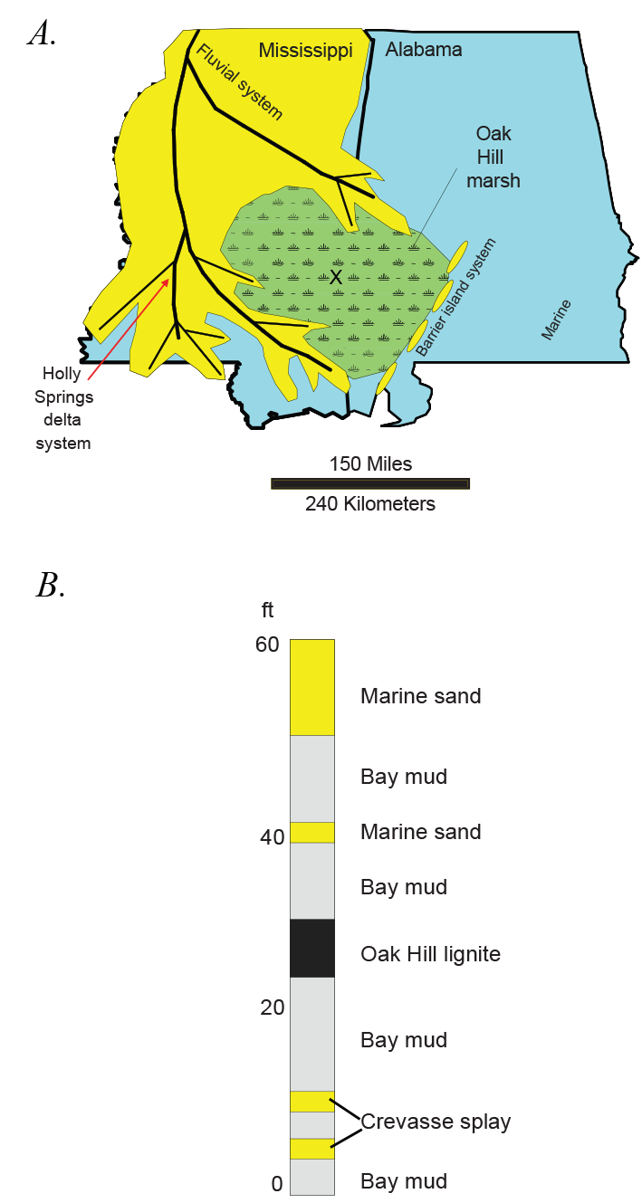
Generalized paleo-depositional map of the Oak Hill marsh and a stratigraphic section of the resulting Oak Hill lignite. A, Map showing the depositional setting in southeastern Mississippi and southwestern Alabama during the time of the lignite accumulation of the Oak Hill Member of the Naheola Formation. Figure modified from Mancini (1983) and Warwick and others (2002). B, Generalized stratigraphic section showing the Oak Hill lignite. The location of the section is from the center of the Oak Hill marsh, as indicated by the “X” on figure 17A. Thickness of the measured interval, in feet (ft), is shown on the left of the section with “0” indicating the base.
Wilcox Group Coal Occurrences
Not all coal beds within the Wilcox Group were included in the Wilcox Coalbed Gas AU of the Wilcox Coalbed Gas TPS described above. Some Wilcox coal beds occur in shallow fresh-water areas that are updip of the 10,000 mg/L TDS groundwater line (Pettijohn, 1996) that was used to establish the updip boundary of the Wilcox Coalbed Gas AU (fig. 8). These coal beds were included in the Cretaceous-Tertiary Coalbed Gas TPS because of their generally low potential to contain economically recoverable coalbed gas. One of two wells that cored Wilcox coals in the freshwater area in Panola County in northeast Texas (fig. 14, labeled as “USGS well with gas show” near the western map extent) had coalbed gas contents that ranged from 0 to about 7 SCF/ton (raw basis, not corrected for ash and moisture content) (Warwick and others, 2005). Based on these geologic conditions, most of these shallow (<1,500 ft depth) Wilcox Group coals in Texas would be included in the Cretaceous-Tertiary Coalbed Gas TPS (fig. 8). Only a narrow belt of Wilcox Group coal-bearing strata in Texas occurs below the 10,000 mg/L TDS groundwater line (as defined by Pettijohn [1996]). The downdip extent of Wilcox coal-bearing strata is limited by the transition into marine-dominated strata at the Lower Cretaceous shelf margin (fig. 6).
Claiborne, Jackson, and Vicksburg Group Coal Occurrences
Multiple coal-bearing intervals also occur within the Eocene Claiborne Group and the overlying Eocene Jackson Group in the Gulf of Mexico Coastal Plain (fig. 4) (Taff, 1900; Plummer, 1932; Renick, 1936; Murray, 1961; Fisher, 1963; Fisher and others, 1970; Le Blanc, 1970; Kaiser, 1974; Dockery, 1976; Hildebrand and others, 1981; Jackson and Garner, 1982; Prior and others, 1985; Ayers, 1986; Ayers and Kaiser, 1986; Williamson and Prior, 1986; Hower and others, 1990; Breyer, 1991; Ewing, 1994; Mancini and Tew, 1994; Tew and Mancini, 1995; Warwick and Crowley, 1995; Warwick and Hook, 1995; Vincent and Ewing, 2000; Hackley and others, 2006b, 2011a, b; Aubourg, 2011; Hook and others, 2011d; Karlsen and others, 2011). Outcrops of the Claiborne and Jackson Groups parallel the modern-day coast of Texas and Louisiana and extend northward into the Mississippi embayment area and eastward into Mississippi and Alabama (fig. 3). The major and minor coal-bearing formations in the Claiborne Group include the Bigford Formation and El Pico Clay in southern Texas, the Sparta Sand in northeast Texas and Louisiana, and the Yegua Formation in Texas (fig. 4). The Manning Formation and its equivalent intervals in Texas are the primary coal-bearing intervals of the Jackson Group (fig. 4). Except in areas influenced by salt structures and faulting, rocks of the Claiborne and Jackson Groups dip gently toward the Gulf of Mexico at four degrees or less.
The coal beds found in the Bigford Formation and El Pico Clay in southern Texas are bituminous in rank like the Upper Cretaceous Olmos Formation coal beds described above. The coal beds of the Bigford Formation and El Pico Clay are only a few feet thick and have limited lateral continuity (Evans, 1974; Warwick and Hook, 1995). Unlike the other coals found in the Gulf of Mexico Coastal Plain, these Claiborne Group coals contain abundant hydrogen-rich algal material which gives the coals a nonbanded, cannel-like texture and composition. Regional subsurface correlations of these coal zones have not been published, nor have any coalbed gas content data. The coalbed gas resource potential of the coals in the Bigford Formation and El Pico Clay is unknown. Low- and high-temperature distillation tests of these nonbanded Claiborne Group coals in the early 1900s indicated anomalously high oil and gas yields (Phillips and Worrell, 1913; Ashley, 1919; see Evans, 1974, for data summary).
The Sparta Sand (middle Claiborne Group) is coal bearing across northern Louisiana, southern Arkansas, and northeastern Texas (Plummer, 1932; Meagher and Aycock, 1942; Williamson and Prior, 1986; Sassen, 1990; Breyer, 1991; Warwick and others, 2004a, 2008). This unit is equivalent to the Koscuisko Formation in Mississippi, which is also coal bearing (fig. 4) (Williamson, 1976; Williamson and Prior, 1986). In the coal-bearing area, the Sparta Sand ranges in thickness from 300 ft in northeast Texas to more than 1,000 ft in the Mississippi embayment (Plummer, 1932; Hosman, 1996). Meagher and Aycock (1942) reported that in northern Louisiana, coal beds of the Sparta Sand that are as thick as 3.75 ft occur in outcrops. Very little is known about the coalbed gas potential of these coal intervals; however, gas associated with the Sparta Sand aquifers in eastern Texas has a mixed origin of migrated thermogenic gas and biogenic gas that was produced within the aquifers (Grossman and others, 1986). Warwick and others (2008) also reported the presence of migrated thermogenic gas in Sparta Sand sandstone reservoirs in north Louisiana.
The Yegua Formation in Texas as well as the equivalent Cockfield Formation in Arkansas and Mississippi form the uppermost unit of the Claiborne Group (fig. 4) and have numerous coal-bearing intervals that have been described in previous reports (Fisher, 1963; Kaiser, 1974; Williamson, 1976; Foss, 1979; Jackson and Garner, 1982; Ayers and Kaiser, 1986; Tewalt, 1986; Yancey; 1997; Hook and others, 2011d). The Yegua Formation has been mapped across the Texas part of the Gulf of Mexico Coastal Plain as a single unit that varies in thickness from approximately 400 to 1,000 ft at the surface (Barnes, 1992) and which has a maximum thickness of more than 1,800 ft (Hosman, 1996). Yegua coal beds in eastern Texas reach a maximum thickness of 7 to 10 ft and net coal thicknesses exceed 10 ft in some areas (Scott, 2000). These coal beds extend into the subsurface and, like the coal beds in the Wilcox Coalbed Gas AU, could have coalbed gas potential if the beds extend deeply (>1,500 ft) and occur in areas of saline groundwater. The presence of biogenic gas—thought to be derived from Yegua Formation coals of eastern Texas—has been reported by Grossman and others (1986) and Martino and others (1998). To date, no coalbed gas exploration data have been published for the Yegua coals and the coalbed gas resource potential remains unknown.
Jackson Group deposits are fluvio-deltaic and coal bearing primarily in east-central and southern Texas; towards the northern and eastern parts of the Gulf of Mexico Coastal Plain, the unit becomes more affected by marine environments (Jackson and Garner, 1982; Williamson and Prior, 1986; Hosman, 1996). In northeast and east-central Texas, the Jackson Group consists of, in ascending order: the Caddell Formation, the Wellborn Sandstone, the Manning Clay, and the Whitsett Formation (fig. 4) (Hosman, 1996). The Jackson Group is undivided in southern Texas and the near-surface coal deposits there have been described in detail by Ayers (1986) and Warwick and others (1996). In east-central Texas, Jackson Group near-surface coal deposits have been described by reports such as Mathewson and Bishop (1979) and Warwick and others (1997a). A few thin (generally less than 2 ft thick), discontinuous coal deposits occur throughout the Jackson Group outcrop area across the northern Gulf of Mexico Coastal Plain and Mississippi embayment area (Williamson and Prior, 1986; Hackley and others, 2006b, 2011a). Similar to the underlying Wilcox and Claiborne Group coals in the Gulf of Mexico Coastal Plain, the Jackson Group coals extend into the subsurface and could have some potential for coalbed gas; however, no coalbed gas data are available to date.
Lignite beds are found in limited extent in outcrops of the lower Oligocene Forest Hill Formation in central-western Mississippi (fig. 4). The lignite beds are rarely greater than 1.5 to 2 ft thick in outcrop, have a high clay content, and are not easily recognized in the medium to deep subsurface south of the outcrop belt (Mellen, 1940; Moore and others, 1964; James Coleman, Jr., USGS, written commun., 2012). However, geophysical well log characteristics suggest that Forest Hill Formation lignite beds may be present in the subsurface in western Mississippi and eastern Louisiana. These well log characteristics appear to extend at least 70 to 80 miles southwest and southeast of the Forest Hill Formation outcrop in central western Mississippi (James Coleman, Jr., USGS, written commun., 2012).
Cretaceous-Tertiary Coalbed Gas Assessment Unit (50470481)
The Cretaceous-Tertiary Coalbed Gas AU (50470481) boundary (fig. 8) is defined in the north by the outcrop of Upper Cretaceous strata in the Mississippi embayment and in Mississippi and Alabama (Schruben and others, 1994). In Texas, the northern (updip) boundary of the AU is defined by the updip outcrop of the Wilcox Group (Warwick and others, 1997b). The southern (downdip) boundary of the AU is defined as the upper Wilcox Group shelf margin of Galloway and others (2000). This shelf margin corresponds to the southern (basinward) extent of the coal-bearing Claiborne and Jackson Groups above the Wilcox Group. The southeastern boundary of the AU is the State/Federal water boundary in southeastern Louisiana, southern Mississippi, and northwestern Florida. The southwestern boundary of the AU is the United States and Mexico border. The AU includes the Lower and Upper Cretaceous and Paleocene–Eocene coal beds of the Midway, Wilcox, Jackson, and Claiborne Groups (exclusive of the other continuous AUs discussed above) (figs. 4, 8). The Cretaceous-Tertiary Coalbed Gas AU was not formally assessed by the USGS Gulf Coast Assessment Team (Dubiel and others, 2007; Warwick and others, 2007a).
Assessment of Coalbed Gas Resources—Summary of Results
The U.S. Geological Survey (USGS) completed an assessment of the undiscovered, technically recoverable, continuous gas potential of Cretaceous–Tertiary coal beds of the onshore areas and State waters of the northern Gulf of Mexico Coastal Plain (fig. 8). This was part of a broader assessment of the undiscovered oil and gas potential of Tertiary strata of the onshore areas and State waters of the Gulf of Mexico Coastal Plain (Dubiel and others, 2007). The USGS assessment was based on geologic factors such as the presence of coal beds that serve as hydrocarbon sources and reservoirs, gas and coal geochemical and physical data, and local groundwater characteristics for three coalbed gas total petroleum systems (TPSs).
Four continuous assessment units (AUs) were defined within the TPSs and estimates of the undiscovered gas resources in these AUs are presented in table 1. The Olmos Coalbed Gas TPS contains two Upper Cretaceous AUs: the Cretaceous Olmos Coalbed Gas AU in southern Texas and the equivalent Rio Escondido Basin Olmos Coalbed Gas AU in northeastern Mexico (fig. 8). The Wilcox Coalbed Gas TPS, which contains the Wilcox Coalbed Gas AU, contains approximately 95 percent of the mean undiscovered coalbed gas resources in the Gulf of Mexico Coastal Plain (table 1). Its boundaries are defined by the northwestern, northern, and northeastern (updip) approximate position of the 10,000 milligrams per liter (mg/L) total dissolved solids (TDS) line drawn to characterize groundwater in the Wilcox Group (see Pettijohn, 1996) and a southern downdip depth of about 6,000 feet to the top of Wilcox Group. Its southeastern boundary in southern Mississippi and northwestern Florida is defined by the State/Federal water boundary offshore and the southwestern boundary is the border with Mexico (fig. 8). The Cretaceous-Tertiary Coalbed Gas TPS defines one AU (the Cretaceous-Tertiary Coalbed Gas AU) that contains all other Cretaceous and Tertiary coal beds that are not part of the Cretaceous Olmos Coalbed Gas AU or the Wilcox Coalbed Gas AU (fig. 8).
The Gulf of Mexico Coastal Plain is an emerging coalbed gas production region. There has been some gas (primarily thermogenic) production from coals of the Upper Cretaceous Olmos Formation in southern Texas, and Wilcox Group coalbed gas isotope data indicate that the gas originated from biogenic reduction of carbon dioxide (CO2). The presence of saline water may have enhanced microbial production of gas in the basin. Current production problems for these Wilcox Group coals are associated with dewatering and proximity to Wilcox Group sandstones.
The USGS assessment of undiscovered, technically recoverable, continuous coalbed gas resources yielded an estimated mean of 4.06 trillion cubic feet of gas (TCFG) in the TPSs and AUs that were included (table 1). Nearly all of the undiscovered gas resource (95 percent, or 3.86 TCFG) was determined to be within the Wilcox Coalbed Gas AU (fig. 8; table 1). The continuous gas resources reside in coalbed reservoirs and in adjacent and interfingered sandstones that were deposited in fluvial and deltaic depositional environments. The assessment results reflect estimates based on vertical drilling technology.
Acknowledgments
The author wishes to thank all members of the U.S. Geological Survey Gulf Coast Assessment Team for their contributions to this report. In particular, Troy Cook provided the estimated ultimate recovery (EUR) plots used in this report, and James Coleman, Jr., provided information on the coal geology of the Mississippi embayment area. Manuscript review comments and suggestions by U.S. Geological Survey colleagues James Coleman, Jr., Robert Milici, Tina Roberts-Ashby, Nancy Stamm, and Susan Tewalt are appreciated. In addition, discussions with staff members of the following agencies greatly contributed to the concepts presented in this paper: Gulf of Mexico Region of the Minerals Management Service (succeeded by the Bureau of Ocean Energy Management); Mississippi Department of Environmental Quality Office of Geology; Louisiana Geological Survey; and The University of Texas at Austin, Bureau of Economic Geology.
References Cited
Ayers, W.B., Jr., 1986, Geology of the San Miguel lignite mine, Jackson Group, south Texas, in Finkelman, R.B., and Casagrande, D.J., eds., Geology of gulf coast lignites—Geological Society of America, Coal Geology Division Field Trip Guidebook: Houston, Tex., Environmental and Coal Associates, p. 54–67.
Ayers, W.B., Jr., and Kaiser, W.R., 1986, Regional depositional setting, resources, and quality of lignite in the Wilcox Group of east Texas and the Jackson Group of east and south Texas, in Finkelman, R.B., and Casagrande, D.J., eds., Geology of gulf coast lignites—Geological Society of America, Coal Geology Division Field Trip Guidebook: Houston, Tex., Environmental and Coal Associates, p. 69–114.
Ayers, W.B., Jr., Lewis, A.H., and Collins, G.F., 1986, Resistivity, lignite, and lithofacies mapping of the Wilcox Group, east central Texas, in Kaiser, W.R., Ambrose, M.L., Ayers, W.B., Jr., Blanchard, P.E., Collins, G.F., Fogg, G.E., Gower, D.L., Ho, C.L., Holland, C.S., Jackson, M.L.W., Jones, C.M., Lewis, A.H., Macpherson, G.L., Mahan, C.A., Mullin, A.H., Prouty, D.A., Tewalt, S.J., and Tweedy, S.W., Geology and ground-water hydrology of deep-basin lignite in the Wilcox Group of east Texas: Austin, Tex., University of Texas at Austin, Bureau of Economic Geology, p. 31–50.
Ayers, W.B., [Jr.], Ruhl, S.K., Hoffmann, M.F., Rushing, J.A., McVay, D.A., and Ramazanova, R.I., 2005, Assessment of resource characteristics and methane content of low-rank coals, Wilcox Group, east-central Texas [abs.]: AAPG Annual Meeting, Calgary, Alberta, Canada, v. 14, p. A8, accessed March 22, 2021, at http://www.searchanddiscovery.com/abstracts/html/2005/annual/abstracts/ayers.htm.
Baker, E.T., Jr., 1995, Stratigraphic nomenclature and geologic sections of the Gulf Coastal Plain of Texas: U.S. Geological Survey Open-File Report 94–461, 34 p., 8 pls., accessed May 21, 2018, at https://pubs.er.usgs.gov/publication/ofr94461.
Barker, C.E., Biewick, L.R.H., Warwick, P.D., and SanFilipo, J.R., 2000, Preliminary gulf coast coalbed methane exploration maps—Depth to Wilcox, apparent Wilcox thickness and vitrinite reflectance: U.S. Geological Survey Open-File Report 2000–113, 2 p., 2 pls., accessed September 23, 2009, at http://pubs.usgs.gov/of/2000/ofr-00-0113/.
Barker, C.E., Warwick, P.D., Gose, M., Scott, R.J., Klein, J.M., and Hook, R.W., 2002, The Sacatosa coalbed methane field—A first for Texas [extended abs.]: AAPG Search and Discovery Article 90007, American Association of Petroleum Geologists Annual Meeting, Houston, Tex., March 10–13, 2002, 8 p., accessed January 5, 2021, at http://www.searchanddiscovery.com/pdfz/abstracts/pdf/2002/annual/EXTENDED/ndx_45602.pdf.html.
Buursink, M.L., Doolan, C.A., Enomoto, C.B., Craddock, W.H., Coleman, J.L., Jr., Brownfield, M.E., Gaswirth, S.B., Klett, T.R., Le, P.A., Leathers-Miller, H.M., Marra, K.R., Mercier, T.J., Pearson, O.N., Pitman, J.K., Schenk, C.J., Tennyson, M.E., Whidden, K.J., and Woodall, C.A., 2018, Assessment of undiscovered conventional oil and gas resources in the downdip Paleogene formations, U.S. Gulf Coast, 2017: U.S. Geological Survey Fact Sheet 2018–3019, 4 p., accessed May 22, 2020, at https://doi.org/10.3133/fs20183019.
Cao, S., Petersen, K., Lerche, I., Lowrie, A., and Sullivan, N., 1993, Cretaceous and Tertiary structural history in northern Louisiana, in Pindell, J.A., and Perkins, B.F., eds., Mesozoic and early Cenozoic development of the Gulf of Mexico and Caribbean region—A context for hydrocarbon exploration: Society of Economic Paleontologists and Mineralogists, Gulf Coast Section Foundation, 13th Annual Research Conference Proceedings, July 1, 1993, p. 77–86, CD-ROM.
Charpentier, R.R., and Klett, T.R., 2005, A Monte Carlo simulation method for the assessment of undiscovered, conventional oil and gas, chap. 21 of USGS Southwestern Wyoming Province Assessment Team, Petroleum systems and geologic assessment of oil and gas in the Southwestern Wyoming Province, Wyoming, Colorado, and Utah: U.S. Geological Survey Digital Data Series DDS–69–D, 5 p., accessed September 23, 2009, at http://pubs.usgs.gov/dds/dds-069/dds-069-d/REPORTS/69_D_CH_21.pdf.
Coleman, J.L., Jr., 2008, Petroleum systems of the Ouachita thrust belt and foreland basins (with emphasis on the Arkoma Basin), in Suneson, N.H., Çemen, I., and Slatt, R.M., eds., Stratigraphic and structural evolution of the Ouachita Mountains and the Arkoma Basin, southeastern Oklahoma and west-central Arkansas; Applications to petroleum exploration, 2004 Field Symposium—Technical Papers: Oklahoma Geological Survey Circular 112B, p. 1–15. [Also available at http://ogs.ou.edu/docs/circulars/C112B.pdf.]
Coleman, J.L., Jr., and Pratt, T.L., 2015, Examination of the Reelfoot rift petroleum system, south-central United States, and the elements that remain for potential exploration and development, in Post, P.J., Coleman, J.L., Jr., Rosen, N.C., Brown, D.E., Roberts-Ashby, T., Khan, P., and Rowan, M., eds., Petroleum systems in “rift” basins: Houston, Tex., Society of Economic Paleontologists and Mineralogists, Gulf Coast Section Foundation, 34th Annual GCSSEPM Foundation Perkins-Rosen Research Conference December 13–16, 2015 (Omni Houston Westside), p. 345–371, CD-ROM.
Condon, S.M., and Dyman, T.S., 2006, 2003 geologic assessment of undiscovered conventional oil and gas resources in the Upper Cretaceous Navarro and Taylor Groups, Western Gulf Province, Texas, chap. 2 of U.S. Geological Survey Western Gulf Province Assessment Team, Petroleum systems and geologic assessment of undiscovered oil and gas, Navarro and Taylor Groups, Western Gulf Province, Texas: U.S. Geological Survey Digital Data Series DDS–69–H, 42 p., accessed September 23, 2009, at http://pubs.usgs.gov/dds/dds-069/dds-069-h/.
Cook, T., 2005, Calculation of estimated ultimate recovery (EUR) for wells in continuous-type oil and gas accumulations, chap. 23 of USGS Southwestern Wyoming Province Assessment Team, Petroleum systems and geologic assessment of oil and gas in the Southwestern Wyoming Province, Wyoming, Colorado, and Utah: U.S. Geological Survey Digital Data Series DDS–69–D, 6 p., accessed September 23, 2009, at http://pubs.usgs.gov/dds/dds-069/dds-069-d/REPORTS/69_D_CH_23.pdf.
Corona-Esquivel, R., Tritlla, J., Benavides-Muñoz, M.E., Piedad-Sánchez, N., and Ferrusquía-Villafranca, I., 2006, Geología, estructura y composición de los principales yacimentos de carbón mineral en México: Boletín de la Sociedad Geológica Mexicana, v. 58, no. 1, p. 141–160, accessed March 22, 2021, at http://boletinsgm.igeolcu.unam.mx/bsgm/vols/epoca04/5801/(5)Corona.pdf.
Crovelli, R.A., 2005, Analytic resource assessment method for continuous petroleum accumulations—The ACCESS assessment method, chap. 22 of USGS Southwestern Wyoming Province Assessment Team, Petroleum systems and geologic assessment of oil and gas in the Southwestern Wyoming Province, Wyoming, Colorado, and Utah: U.S. Geological Survey Digital Data Series DDS–69–D, 6 p., accessed September 23, 2009, at http://pubs.usgs.gov/dds/dds-069/dds-069-d/REPORTS/69_D_CH_22.pdf.
Dennen, K.O., 2009, Executive summary—The National Coal Resource Assessment overview, chap. A of Pierce, B.S., and Dennen, K.O., eds., The National Coal Resource Assessment overview: U.S. Geological Survey Professional Paper 1625–F, 7 p., accessed September 23, 2009, at http://pubs.usgs.gov/pp/1625f/downloads/ChapterA.pdf.
Doney, H.H., 1986, Recent and current research on Wilcox lignite in northern Louisiana, in Finkelman, R.B., and Casagrande, D.J., eds., Geology of gulf coast lignites—Geological Society of America, Coal Geology Division Field Trip Guidebook: Houston, Tex., Environmental and Coal Associates, p. 156–186.
Dubiel, R.F., Pitman, J.K., Pearson, O.N., Condon, S.M., Warwick, P.D., Karlsen, A.W., Coleman, J.L., Hackley, P.C., Hayba, D.O., Swanson, S.M., Charpentier, R.R., Cook, T.A., Klett, T.R., Pollastro, R.M., and Schenk, C.J., 2007, Assessment of undiscovered oil and gas resources in Tertiary strata and Cretaceous–Tertiary coalbed gas of the gulf coast: U.S. Geological Survey Fact Sheet FS–2007–3066, 4 p., accessed September 23, 2009, at http://pubs.usgs.gov/fs/2007/3066/.
Dubiel, R.F.; Warwick, P.D.; Swanson, S.; Burke, L.; Biewick, L.R.H.; Charpentier, R.R.; Coleman, J.L.; Cook, T.A.; Dennen, K.; Doolan, C.; Enomoto, C.; Hackley, P.C.; Karlsen, A.W.; Klett, T.R.; Kinney, S.A.; Lewan, M.D.; Merrill, M.; Pearson, K.; Pearson, O.N.; Pitman, J.K.; Pollastro, R.M.; Rowan, E.L.; Schenk, C.J.; and Valentine, B., 2011, Assessment of undiscovered oil and gas resources in Jurassic and Cretaceous strata of the gulf coast, 2010: U.S. Geological Survey Fact Sheet 2011–3020, 4 p., accessed September 30, 2011, at http://pubs.usgs.gov/fs/2011/3020/.
Dyman, T.S., and Condon, S.M., 2006, Assessment of undiscovered conventional oil and gas resources—Upper Jurassic–Lower Cretaceous Cotton Valley Group, Jurassic Smackover Interior Salt Basins Total Petroleum System, in the East Texas basin and Louisiana-Mississippi Salt Basins Provinces, chap. 2 of U.S. Geological Survey Gulf Coast Region Assessment Team, Petroleum systems and geologic assessment of undiscovered oil and gas, Cotton Valley Group and Travis Peak–Hosston Formations, East Texas Basin and Louisiana-Mississippi Salt Basins Provinces of the northern gulf coast region: U.S. Geological Survey Digital Data Series DDS–69–E, 52 p., CD-ROM, accessed September 24, 2009, at http://pubs.usgs.gov/dds/dds-069/dds-069-e/.
Eguiluz de Antuñano, S., and Amezcua Torres, N., 2003, Coalbed methane resources of the Sabinas Basin, Coahuila, México, in Bartolini, C., Buffler, R.T., and Blickwede, J.F., eds., The Circum-Gulf of Mexico and the Caribbean—Hydrocarbon habitats, basin formation, and plate tectonics: AAPG Memoir 79, p. 395–402.
Eoff, J.D., Biewick, L.R.H., Brownfield, M.E., Burke, L., Charpentier, R.R., Dubiel, R.F., Gaswirth, S.B., Gianoutsos, N.J., Kinney, S.A., Klett, T.R., Leathers, H.M., Mercier, T.J., Paxton, S.T., Pearson, O.N., Pitman, J.K., Schenk, C.J., Tennyson, M.E., and Whidden, K.J., 2015, Assessment of undiscovered oil and gas resources in sandstone reservoirs of the Cotton Valley Group, U.S. Gulf Coast, 2015: U.S. Geological Survey Fact Sheet 2015–3050, 2 p., accessed May 22, 2020, at http://dx.doi.org/10.3133/fs20153050.
Ewing, T.E., 1999, Regional geologic setting of south Texas and the Santo Thomas coal deposits, in Warwick, P.D., Aubourg, C.E., and Willett, J.C., eds., Tertiary coals in south Texas—Anomalous cannel-like coals of Webb County (Claiborne Group, Eocene) and lignites of Atascosa County (Jackson Group, Eocene)—Geologic setting, character, source-rock and coal-bed methane potential: U.S. Geological Survey Open-File Report 99–301, p. 5–12, accessed September 24, 2009, at http://pubs.usgs.gov/pdf/of/ofr99301/chapter1.pdf.
Ewing, T.E., 2003, Review of the tectonic history of the lower Rio Grande border region, south Texas and Mexico, and implications for hydrocarbon exploration, in Rosen, N.C., ed., Structure and stratigraphy of south Texas and northeast Mexico—Applications to exploration: Gulf Coast Section of the Society of Economic Paleontologists and Mineralogists Foundation (Houston, Texas) and South Texas Geological Society (San Antonio, Texas), p. 7–21, CD-ROM.
Fisk, H.N., 1944, Geological investigation of the alluvial valley of the lower Mississippi River: Vicksburg, Miss., War Department, Corps of Engineers, Mississippi River Commission, 78 p., 33 pls., accessed March 22, 2021, at https://biotech.law.lsu.edu/climate/mississippi/fisk/fisk.htm.
Flores, R.M., 2004, Coalbed methane in the Powder River Basin, Wyoming and Montana—An assessment of the Tertiary-Upper Cretaceous Coalbed Methane Total Petroleum System, chap. 2 of USGS Powder River Basin Province Assessment Team, Total petroleum system and assessment of coalbed gas in the Powder River Basin Province, Wyoming and Montana: U.S. Geological Survey Digital Data Series DDS–69–C, 57 p., accessed September 24, 2009, at http://pubs.usgs.gov/dds/dds-069/dds-069-c/REPORTS/Chapter_2.pdf.
Frezon, S.E., and Finn, T.M., comps., 1988, Map of sedimentary basins in the conterminous United States: U.S. Geological Survey Oil and Gas Investigation Map OM–223, 1 sheet, scale 1:5,000,000. [Also available at https://doi.org/10.3133/om223; edited by K.L. Varnes.]
Hackley, P.C., Enomoto, C.B., Valentine, B.J., Rouse, W.A., Lohr, C.D., Dulong, F.T., Hatcherian, J.J., Brennan, S.T., Craddock, W.H., Finn, T.M., Gaswirth, S.B., Le, P.A., Leathers-Miller, H.M., Marra, K.R., Mercier, T.J., Paxton, S.T., Whidden, K.J., Woodall, C.A., and Schenk, C.J., 2018, Assessment of undiscovered continuous oil and gas resources in the Upper Cretaceous Tuscaloosa marine shale of the U.S. Gulf Coast, 2018: U.S. Geological Survey Fact Sheet 2018–3043, 2 p., accessed May 22, 2020, at https://doi.org/10.3133/fs20183043.
Hackley, P.C., Hook, R.W., and Warwick, P.D., 2005, Huminite reflectance measurements of Paleocene and Upper Cretaceous coals from borehole cuttings, Zavala and Dimmit Counties, south Texas: U.S. Geological Survey Open-File Report 2005–1144, 13 p., accessed September 24, 2009, at http://pubs.usgs.gov/of/2005/1144/.
Hackley, P.C., Ratchford, M.E., and Warwick, P.D., 2006a, Reflectance measurements of well cuttings from Ashley and Bradley Counties, Arkansas: U.S. Geological Survey Open-File Report 2006–1155, 29 p., accessed September 24, 2009, at http://pubs.usgs.gov/of/2006/1155/.
Hackley, P.C., Warwick, P.D., Breland, F.C., Jr., Richard, T.E., and Ross, K., 2007b, Results from coalbed methane drilling in Winn Parish, Louisiana: U.S. Geological Survey Open-File Report 2007–1061, 45 p., accessed September 24, 2009, at http://pubs.usgs.gov/of/2007/1061.
Hackley, P.C., Warwick, P.D., Hook, R.W., Alimi, H., Mastalerz, M., and Swanson, S.M., 2012, Organic geochemistry and petrology of subsurface Paleocene–Eocene Wilcox and Claiborne Group coal beds, Zavala County, Maverick Basin, Texas, USA: Organic Geochemistry, v. 46, p. 137–153, accessed March 22, 2021, at http://dx.doi.org/10.1016/j.orggeochem.2012.02.008.
Hackley, P.C., Warwick, P.D., Thomas, R.E., and Nichols, D.J., 2006b, Review of lignite resources of western Tennessee and the Jackson Purchase area, western Kentucky: U.S. Geological Survey Open-File Report 2006–1078, 34 p., accessed September 24, 2009, at http://pubs.usgs.gov/of/2006/1078/.
Hackley, P.C., Warwick, P.D., Thomas, R.E., and Nichols, D.J., 2011a, A review of lignite resources of western Tennessee and the Jackson Purchase area, western Kentucky, chap. 18 of Warwick, P.D., Karlsen, A.K., Merrill, M., and Valentine, B.J., eds., Geologic assessment of coal in the Gulf of Mexico Coastal Plain: AAPG Studies in Geology, v. 62, p. 326–347.
Hackley, P.C., Willett, J.C., Warwick, P.D., Law, S.J., and Nichols, D.J., 2011b, A review of the lignite resources of Arkansas, chap. 17 of Warwick, P.D., Karlsen, A.K., Merrill, M., and Valentine, B.J., eds., Geologic assessment of coal in the Gulf of Mexico Coastal Plain: AAPG Studies in Geology, v. 62, p. 313–325.
Hanor, J.S., and Sassen, R., 1990, Evidence for large-scale vertical and lateral migration of formation waters, dissolved salt, and crude oil in the Louisiana Gulf Coast, in Schumacher, D., and Perkins, B.F., eds., Gulf coast oils and gases—Their characteristics, origin, distribution, and exploration and production significance: Proceedings of the Ninth Annual Research Conference, Gulf Coast Section, Society of Economic Paleontologists and Mineralogists Foundation, p. 283–296.
Higley, D.K., 2007, Petroleum systems and assessment of undiscovered oil and gas in the Raton Basin–Sierra Grande Uplift Province, Colorado and New Mexico, chap. 2 of Higley, D.K., comp., Petroleum systems and assessment of undiscovered oil and gas in the Raton Basin–Sierra Grande Uplift Province, Colorado and New Mexico—USGS Province 41: U.S. Geological Survey Digital Data Series DDS–69–N, 124 p., accessed September 24, 2009, at http://pubs.usgs.gov/dds/dds-069/dds-069-n/.
Hook, R.W., and Warwick, P.D., 2011, Eocene bituminous coal deposits of the Claiborne Group, Webb County, Texas, chap. 12 of Warwick, P.D., Karlsen, A.K., Merrill, M., and Valentine, B.J., eds., Geologic assessment of coal in the Gulf of Mexico Coastal Plain: AAPG Studies in Geology, v. 62, p. 269–276.
Hook, R.W., Warwick, P.D., Karlsen, A.W., and Tewalt, S.J., 2011a, Bibliography of the Gulf of Mexico Coastal Plain coal geology, chap. 19 of Warwick, P.D., Karlsen, A.K., Merrill, M., and Valentine, B.J., eds., Geologic assessment of coal in the Gulf of Mexico Coastal Plain: AAPG Studies in Geology, v. 62, p. 348–389.
Hook, R.W., Warwick, P.D., and SanFilipo, J.R., 2011b, Upper Cretaceous bituminous coal deposits of the Olmos Formation, Maverick County, Texas, chap. 13 of Warwick, P.D., Karlsen, A.K., Merrill, M., and Valentine, B.J., eds., Geologic assessment of coal in the Gulf of Mexico Coastal Plain: AAPG Studies in Geology, v. 62, p. 277–285.
Hook, R.W., Warwick, P.D., SanFilipo, J.R., and Nichols, D.J., 2011c, Paleogene coal deposits of the Wilcox Group and the Indio Formation of south Texas, chap. 11 of Warwick, P.D., Karlsen, A.K., Merrill, M., and Valentine, B.J., eds., Geologic assessment of coal in the Gulf of Mexico Coastal Plain: AAPG Studies in Geology, v. 62, p. 260–268.
Hook, R.W., Warwick, P.D., Swanson, S.S., and Hackley, P.C., 2011d, Eocene Yegua Formation (Claiborne Group) and Jackson Group lignite deposits of Texas, chap. 14 of Warwick, P.D., Karlsen, A.K., Merrill, M., and Valentine, B.J., eds., Geologic assessment of coal in the Gulf of Mexico Coastal Plain: AAPG Studies in Geology, v. 62, p. 286–297.
Hosman, R.L., 1996, Regional stratigraphic and subsurface geology of Cenozoic deposits, Gulf Coastal Plain, south-central United States: U.S. Geological Survey Professional Paper 1416–G, p. G1–G35, accessed March 22, 2021, at http://pubs.er.usgs.gov/publication/pp1416G.
Hosman, R.L., and Weiss, J.S., 1991, Geohydrologic units of the Mississippi Embayment and Texas Coastal Uplands aquifer systems, south-central United States: U.S. Geological Survey Professional Paper 1416–B, p. B1–B19, 19 pls., accessed September 24, 2009, at http://pubs.er.usgs.gov/usgspubs/pp/pp1416B.
Kaiser, W.R., 1986, Geology and ground-water hydrology of deep-basin lignite in the Wilcox Group of east Texas—A summary, in Kaiser, W.R., Ambrose, M.L., Ayers, W.B., Jr., Blanchard, P.E., Collins, G.F., Fogg, G.E., Gower, D.L., Ho, C.L., Holland, C.S., Jackson, M.L.W., Jones, C.M., Lewis, A.H., Macpherson, G.L., Mahan, C.A., Mullin, A.H., Prouty, D.A., Tewalt, S.J., and Tweedy, S.W., Geology and ground-water hydrology of deep-basin lignite in the Wilcox Group of east Texas: Austin, Tex., University of Texas at Austin, Bureau of Economic Geology, p. 3–10.
Kaiser, W.R., Ambrose, M.L., Ayers, W.B., Jr., Blanchard, P.E., Collins, G.F., Fogg, G.E., Gower, D.L., Ho, C.L., Holland, C.S., Jackson, M.L.W., Jones, C.M., Lewis, A.H., Macpherson, G.L., Mahan, C.A., Mullin, A.H., Prouty, D.A., Tewalt, S.J., and Tweedy, S.W., 1986, Geology and ground-water hydrology of deep-basin lignite in the Wilcox Group of east Texas: Austin, Tex., University of Texas at Austin, Bureau of Economic Geology, 182 p.
Karlsen, A.W., Warwick, P.D., Hook, R.W., SanFilipo, J.R., Barker, C.E., and Klein, J.M., 2002, Characterization of core extracted from the Olmos Formation (Cretaceous), southwest Texas: U.S. Geological Survey Open-File Report 02–417, 66 p., accessed September 24, 2009, at http://pubs.usgs.gov/of/2002/of02-417/.
Klett, T.R., and Schmoker, J.W., 2005, U.S. Geological Survey input-data form and operational procedure for the assessment of continuous petroleum accumulations, 2002, chap. 18 of USGS Southwestern Wyoming Province Assessment Team, Petroleum systems and geologic assessment of oil and gas in the Southwestern Wyoming Province, Wyoming, Colorado, and Utah: U.S. Geological Survey Digital Data Series DDS–69–D, 8 p., accessed September 24, 2009, at http://certmapper.cr.usgs.gov/data/noga00/natl/text/CH_18.pdf.
Klett, T.R., Schmoker, J.W., and Ahlbrandt, T.S., 2000, Assessment hierarchy and initial province ranking, chap. RH of U.S. Geological Survey World Energy Assessment Team, U.S. Geological Survey world petroleum assessment 2000—Description and results: U.S. Geological Survey Digital Data Series DDS–60, p. RH–1 to RH–24, 3 figs., 1 table, accessed December 11, 2020, at https://certmapper.cr.usgs.gov/data/PubArchives/WEcont/chaps/RH.pdf. [Also available at https://doi.org/10.3133/ds60.]
Klett, T.R., Schmoker, J.W., and Charpentier, R.R., 2005, U.S. Geological Survey input-data form and operational procedure for the assessment of conventional petroleum accumulations, chap. 20 of USGS Southwestern Wyoming Province Assessment Team, Petroleum systems and geologic assessment of oil and gas in the Southwestern Wyoming Province, Wyoming, Colorado, and Utah: U.S. Geological Survey Digital Data Series DDS–69–D, 7 p., accessed September 24, 2009, at http://certmapper.cr.usgs.gov/data/noga00/natl/text/CH_20.pdf.
Louisiana Department of Natural Resources, 2007, SONRIS database, accessed March 22, 2021, at https://www.sonris.com.
Louisiana Department of Natural Resources, 2009, Office of Conservation lignite mine map, accessed March 22, 2021, at https://www.sonris.com.
Luppens, J.A., 1986, Distribution of lignite in the lower Wilcox Group in the Sabine uplift region of Texas and Louisiana, in Finkelman, R.B., and Casagrande, D.J., eds., Geology of gulf coast lignites—Geological Society of America, Coal Geology Division Field Trip Guidebook: Houston, Tex., Environmental and Coal Associates, p. 218–223.
Mahmoud, S.E.R., Pessagno, E.A., Jr., and Bhattacharya, J.P., 1999, Sequence stratigraphic analyses of the Upper Cretaceous deposits, Rio Grande Embayment, using well logs, cores and outcrops [abs.]: Gulf Coast Association of Geological Societies Transactions, v. 49, p. 4. [Also available at http://archives.datapages.com/data/gcags/data/049/049001/0004B.HTM.]
McBride, E.F., and Caffey, K.C., 1979, Geologic report on the Upper Cretaceous coal-bearing rocks, Rio Escondido Basin, Coahuila, Mexico: Boletín de la Sociedad Geológica Mexicana, v. 40, nos. 1–2, p. 21–47, accessed March 22, 2021, at http://boletinsgm.igeolcu.unam.mx/bsgm/vols/epoca03/4001/1979-40-1%20y%202%20McBride-Caffey.pdf.
McIntosh, J.C., Warwick, P.D., Martini, A.M., and Osborn, S., 2007a, Geochemical linkages between groundwater flow and microbial methane generation in shallow coal beds and fractured black shales—Northern Gulf of Mexico and midcontinent U.S. basins [abs.]: American Association of Petroleum Geologists, 2007 Annual Convention Abstracts, v. 16, p. 92, accessed October 1, 2009, at http://www.searchanddiscovery.net/abstracts/html/2007/annual/abstracts/lbMcIntosh.htm?q=%2Btext%3Amcintosh.
McIntosh, J.C., Warwick, P.D., Martini, A.M., and Osborn, S.G., 2007b, Coupled hydrology and biogeochemistry of Paleocene–Eocene coal beds, northern Gulf of Mexico [abs.]: Geological Society of America Abstracts with Programs, v. 39, no. 6, p. 257, accessed September 24, 2021, at https://gsa.confex.com/gsa/2007AM/webprogram/Paper128809.html.
McVay, D.A., Ayers, W.B., Jr., and Jensen, J.L., 2005, CO2 sequestration potential of Texas low-rank coals: Texas Engineering Experiment Station Technical Report FC26–02NT41588, 28 p., accessed September 24, 2009, at http://www.osti.gov/bridge/servlets/purl/850189-LfqIEc/850189.pdf.
Merrill, M.D., Valentine, B.J., and Dennen, K.O., 2012, Overview of shallow coal exploration drill-hole data—Alabama, Georgia, Kentucky, Louisiana, Mississippi, Missouri, North Carolina, South Carolina, Tennessee, and Texas, chap. A of Valentine, B.J., and Dennen, K.O., eds., Shallow coal exploration drill-hole data—Alabama, Georgia, Kentucky, Louisiana, Mississippi, Missouri, North Carolina, South Carolina, Tennessee, and Texas: U.S. Geological Survey Open-File Report 2011–1261, 6 p., 12 app., accessed May 16, 2012, at http://pubs.usgs.gov/of/2011/1261/.
Moore, W.H., Parks, W.S., and Kern, M.K., 1964, Type localities sampling program, in Bicker, A.R., Jr., Engelhardt, D.W., Howe, H.V., Kern, M.K., Mellen, F.F., Moore, W.H., and Parks, W.S., Mississippi geologic research papers—1964: Mississippi Geological, Economic and Topographical Survey Bulletin 104, p. 7–32.
Oman, J.K., 1986, Stratigraphic framework and correlations of the Tertiary lignite-bearing formations from southeast Missouri to the Fort Pillow test well of west Tennessee: U.S. Geological Survey Bulletin 1644, 7 p. 2 pls., accessed January 25, 2018, at https://pubs.er.usgs.gov/publication/b1644.
Page, W.R., VanSistine, D.P., and Turner, K.J., 2005, Preliminary geologic map of southernmost Texas, United States, and parts of Tamaulipas and Nuevo Leon, Mexico—Environmental health investigations in the United States-Mexico border region: U.S. Geological Survey Open-File Report 2005–1409, Denver, Colo., accessed January 25, 2018, at https://pubs.usgs.gov/of/2005/1409/.
Parks, W.S., and Carmichael, J.K., 1990, Geology and ground-water resources of the Cockfield Formation in western Tennessee: U.S. Geological Survey Water-Resources Investigations Report 88–4181, 17 p., accessed January 25, 2018, at https://pubs.er.usgs.gov/publication/wri884181.
Palmer, A.R., and Geissman, J., comps., 1999, 1999 geologic time scale: The Geological Society of America, Product code CTS004, 1 p., accessed September 24, 2021, at http://www.geosociety.org/GSA/Education_Careers/Geologic_Time_Scale/GSA/timescale/home.aspx.
Paxton, S.T., Pitman, J.K., Kinney, S.A., Gianoutsos, N.J., Pearson, O.N., Whidden, K.J., Dubiel, R.F., Schenk, C.J., Burke, L.A., Klett, T.R., Leathers-Miller, H.M., Mercier, T.J., Haines, S.S., Varela, B.A., Le, P.A., Finn, T.M., Gaswirth, S.B., Hawkins, S.J., Marra, K.R., and Tennyson, M.E., 2017a, Assessment of undiscovered oil and gas resources in the Bossier Formation, U.S. Gulf Coast, 2016: U.S. Geological Survey Fact Sheet 2017–3015, 2 p., accessed January 24, 2018, at https://doi.org/10.3133/fs20173015.
Paxton, S.T., Pitman, J.K., Kinney, S.A., Gianoutsos, N.J., Pearson, O.N., Whidden, K.J., Dubiel, R.F., Schenk, C.J., Burke, L.A., Klett, T.R., Leathers-Miller, H.M., Mercier, T.J., Haines, S.S., Varela, B.A., Le, P.A., Finn, T.M., Gaswirth, S.B., Hawkins, S.J., Marra, K.R., and Tennyson, M.E., 2017b, Assessment of undiscovered oil and gas resources in the Haynesville Formation, U.S. Gulf Coast, 2016: U.S. Geological Survey Fact Sheet 2017–3016, 2 p., accessed January 24, 2018, at https://doi.org/10.3133/fs20173016.
Pettijohn, R.A., 1996, Geochemistry of ground water in the gulf coast aquifer systems, south-central United States: USGS Water Resources Investigations Report 96–4107, p. 1–158, accessed September 24, 2009, at http://pubs.er.usgs.gov/usgspubs/wri/wri964107.
Pierce, B.S., Willett, J.C., Swanson, S.M., and Dennen, K.O., 2011, Coal quality of assessed areas of Texas and Louisiana, gulf coastal plain, chap. 3 of Warwick, P.D., Karlsen, A.K., Merrill, M., and Valentine, B.J., eds., Geologic assessment of coal in the Gulf of Mexico Coastal Plain: AAPG Studies in Geology, v. 62, p. 44–94.
Pitman, J.K., Dubiel, R.F., Nelson, P.H., Kibler, J., Charpentier, R.R., Cook, T.A., Klett, T.R., Pollastro, R., and Schenk, C.J., 2007, Assessment of undiscovered gas resources in the Upper Cretaceous Tuscaloosa and Woodbine Formations, Western Gulf Province of the Gulf Coast Region, Louisiana and Texas, 2007: U.S. Geological Survey Fact Sheet 2006–3146, 2 p., accessed September 30, 2009, at http://pubs.usgs.gov/fs/2006/3146/.
Railroad Commission of Texas, 2007, Public GIS map viewer for oil, gas, and pipeline data, accessed March 22, 2021, at https://www.rrc.state.tx.us/resource-center/research/gis-viewer/.
Railroad Commission of Texas, 2009, Texas coal production, accessed March 22, 2021, at https://www.rrc.state.tx.us/surface-mining/programs/surface-coal-mining-exploration/.
Roberts-Ashby, T.L., Hackley, P.C., Lohr, C.D., Schenk, C.J., Mercier, T.J., Whidden, K.J., Le, P.A., Tennyson, M.E., Gaswirth, S.B., Woodall, C.A., Brownfield, M.E., Leathers-Miller, H.M., Marra, K.R., and Finn, T.M., 2019, Assessment of undiscovered oil and gas resources in the South Florida basin, 2016: U.S. Geological Survey Fact Sheet 2018–3074, 4 p., accessed May 22, 2020, at https://doi.org/10.3133/fs20183074.
SanFilipo, J.R., 1999, Some speculations on coal rank anomalies of the South Texas Gulf Province and adjacent areas of Mexico and their impact on coalbed methane and source rock potential, in Warwick, P.D., Aubourg, C.E., and Willett, J.C., eds., Tertiary Coals in south Texas—Anomalous cannel-like coals of Webb County (Claiborne Group, Eocene) and lignites of Atascosa County (Jackson Group, Eocene)—Geologic setting, character, source-rock and coal-bed methane potential: U.S. Geological Survey Open-File Report 99–301, p. 37–47, accessed September 24, 2009, at http://pubs.usgs.gov/pdf/of/ofr99301.
SanFilipo, J.R., Barker, C.E., Stanton, R.W., Warwick, P.D., and Morris, L.E., 2000a, A shallow coal-bed methane show in the Gulf Coast of Texas, indication of down-dip commercial potential? [abs.]: American Association of Petroleum Geologists 2000 Annual Convention Program, v. 2000, p. A130–A131, accessed October 1, 2009, at http://www.searchanddiscovery.net/abstracts/html/2000/annual/abstracts/0593.htm.
SanFilipo, J.R., Warwick, P.D., Barker, C.E., Biewick, L.R.H., and Stanton, R.W., 2000b, A show of methane from shallow low-rank coal in the Gulf Coast of Texas, and its implications for basin-wide commercial potential, in Mastalerz, M., ed., The Society for Organic Petrology: Abstracts and Program, v. 17, 2 p.
Schenk, C.J., and Viger, R.J., 1996a, East Texas Basin Province (048) and Louisiana-Mississippi Salt Basins Province (049): U.S. Geological Survey Digital Data Series DDS–30, release 2, accessed March 23, 2021, at https://certmapper.cr.usgs.gov/data/noga95/prov49/text/prov49.pdf.
Schenk, C.J., and Viger, R.J., 1996b, Western Gulf Province (047): U.S. Geological Survey Digital Data Series DDS–30, release 2, accessed March 23, 2021, at https://certmapper.cr.usgs.gov/data/noga95/prov47/text/prov47.pdf.
Schmoker, J.W., 2005, U.S. Geological Survey assessment concepts for continuous petroleum accumulations, chap. 13 of USGS Southwestern Wyoming Province Assessment Team, Petroleum systems and geologic assessment of oil and gas in the Southwestern Wyoming Province, Wyoming, Colorado, and Utah: U.S. Geological Survey Digital Data Series DDS–69–D, 7 p., accessed September 24, 2009, at http://certmapper.cr.usgs.gov/data/noga00/natl/text/CH_13.pdf.
Schmoker, J.W., and Klett, T.R., 2005, U.S. Geological Survey assessment concepts for conventional petroleum accumulations, chap. 19 of USGS Southwestern Wyoming Province Assessment Team, Petroleum systems and geologic assessment of oil and gas in the Southwestern Wyoming Province, Wyoming, Colorado, and Utah: U.S. Geological Survey Digital Data Series DDS–69–D, 6 p., accessed September 24, 2009, at http://certmapper.cr.usgs.gov/data/noga00/natl/text/CH_19.pdf.
Schrader, T.P., and Scheiderer, R.M., 2003, Status of water levels in aquifers in the Nacatoch Sand of southwestern and northeastern Arkansas and the Tokio Formation of southwestern Arkansas, 2002: U.S. Geological Survey Water-Resources Investigations Report 03–4284, 24 p., accessed September 24, 2009, at http://pubs.usgs.gov/wri/wri03-4284/WRIR03-4284.pdf.
Schruben, P.G., Arndt, R.E., and Bawiec, W.J., 1994, Geology of the conterminous United States at 1:2,500,000 scale—A digital representation of the 1974 P.B. King and H.M. Beikman map (release 2, 1998), with display software by R.A. Ambroziak: U.S. Geological Survey Digital Data Series DDS–11, accessed September 24, 2009, at http://pubs.usgs.gov/dds/dds11/.
Scott, R.J., 2003, The Maverick basin—New technology—New success, in Rosen, N.C., ed., Structure and stratigraphy of south Texas and northeast Mexico, applications to exploration: Houston, Tex., Society of Economic Paleontologists and Mineralogists, Gulf Coast Section Foundation, and South Texas Geological Society, p. 84–121, CD-ROM.
Self, D.M., and Williamson, D.R., 1977, Trend areas and exploration techniques—Occurrence and characteristics of Midway and Wilcox lignites in Mississippi and Alabama, in Campbell, M.D., ed., Geology of alternate energy resources in the south-central United States: Houston, Tex., Houston Geological Society, p. 161–177.
Schwoebel, J., Kravits, S., Zambrano, A., and Gonzalez, F., 1993, Design, installation and effectiveness of a degasification system at the Pasta de Conchos Mine, Nueva Rosita, Coahuila, Mexico, in The 1993 International Coalbed Methane Symposium, Proceedings, Birmingham Alabama, May 17–21, 1993: University of Alabama, Gas Research Institute, U.S. Mine Safety and Health Administration, Geological Survey of Alabama, U.S. Department of Energy, U.S. Environmental Protection Agency, v. 2, paper 9369, p. 483–488.
Stephens, B.P., 2001, Basement controls on hydrocarbon systems, depositional pathways, and exploration plays beyond the Sigsbee Escarpment in the central Gulf of Mexico, in Fillon, R.H., Rosen, N.C., Weimer, P., Lowie, A., Pettingill, H., Phair, R.L., Roberts, H.H., and van Hoorn, R., eds., Petroleum systems of deep-water basins—Global and Gulf of Mexico experience: Houston, Tex., Society of Economic Paleontologists and Mineralogists, Gulf Coast Section Foundation 21st Annual Research Conference, December 2–5, 2001, p. 129–157, CD-ROM.
Stricker, G.D., Flores, R.M., McGarry, D.E., Stillwell, D.P., Hoppe, D.J., Stillwell, C.R., Ochs, A.M., Ellis, M.S., Osvald, K.S., Taylor, S.L., Thorvaldson, M.C., Trippi, M.H., Grose, S.D., Crockett, F.J., and Shariff, A.J., 2006, Gas desorption and adsorption isotherm studies of coals in the Powder River Basin, Wyoming and adjacent basins in Wyoming and North Dakota: U.S. Geological Survey Open-File Report 2006–1174, 21 p., 3 app., accessed September 30, 2011, at http://pubs.usgs.gov/of/2006/1174/.
Sweetkind, D.S., and Warwick, P.D., 2022, Digital subsurface data from previously published contour map of the top of the Wilcox Group, northern Gulf of Mexico coastal region: U.S. Geological Survey data release, accessed November 17, 2022, at https://doi.org/10.5066/P973641H.
Tewalt, S.J., Finkelman, R.B., and Barnett, R.L., 1990, Bibliography of gulf coast lignite geology: U.S. Geological Survey Open-File Report 90–549, 43 p., accessed September 24, 2009, at http://pubs.er.usgs.gov/usgspubs/ofr/ofr90549.
Tully, J., comp., 1996, Coal fields of the conterminous United States: U.S. Geological Survey Open-File Report 96–92, 1 oversize sheet, scale 1:5,000,000, accessed April 5, 2012, at http://pubs.usgs.gov/of/1996/of96-092/index.htm.
U.S. Energy Information Administration, 2008, Annual coal report: U.S. Energy Information Administration [Report] DOE/EIA–0584 (2008), accessed September 30, 2009, at http://www.eia.doe.gov/cneaf/coal/page/acr/acr_sum.html.
U.S. Energy Information Administration, 2020, Coal data browser: U.S. Energy Information Administration web page, accessed February 16, 2020, at https://www.eia.gov/coal/data/browser/.
U.S. Energy Information Administration, 2021, Natural gas explained—Where our natural gas comes from: U.S. Energy Information Administration web page, accessed March 22, 2021, at https://www.eia.gov/energyexplained/natural-gas/where-our-natural-gas-comes-from.php.
U.S. Environmental Protection Agency Coalbed Methane Outreach Program, 2015, Mexico, in Coal mine methane country profiles: U.S. Environmental Protection Agency Coalbed Methane Outreach Program, Chapter 21, p. 178–190, accessed March 23, 2021, at https://www.globalmethane.org/documents/Toolsres_coal_overview_ch21.pdf.
U.S. Geological Survey, 2010, The U.S. Geological Survey Energy Resources Program: U.S. Geological Survey Fact Sheet 2010–3100, 6 p., accessed January 24, 2018, at https://pubs.usgs.gov/fs/2010/3100/.
U.S. Geological Survey National Assessment Review Team, 2006, U.S. Geological Survey methodology for the assessment of undiscovered oil and gas resources, app. 6 of U.S. Departments of the Interior, Agriculture, and Energy, Scientific inventory of onshore Federal lands’ oil and gas resources and the extent and nature of restrictions or impediments to their development—Phase II cumulative inventory: p. 227–235, accessed September 24, 2009, at http://www.blm.gov/epca/.
U.S. Geological Survey National Oil and Gas Resource Assessment Team, 1995, 1995 national assessment of United States oil and gas resources: U.S. Geological Survey Circular 1118, 20 p., accessed March 23, 2021, at https://doi.org/10.3133/cir1118.
Warwick, P.D., ed., 2004b, Selected presentations on coal-bed gas in the eastern United States (ver. 1): U.S. Geological Survey Open-File Report 2004–1273, accessed September 24, 2009, at http://pubs.usgs.gov/of/2004/1273/.
Warwick, P.D., 2017, Geologic assessment of undiscovered conventional oil and gas resources in the lower Paleogene Midway and Wilcox Groups, and the Carrizo Sand of the Claiborne Group, of the northern gulf coast region: U.S. Geological Survey Open-File Report 2017–1111, 67 p., accessed January 24, 2018, at https://doi.org/10.3133/ofr20171111.
Warwick, P.D., Barker, C.E., SanFilipo, J.R., and Biewick, L.R.H., 2000a, Preliminary evaluation of the coalbed methane resources of the Gulf Coastal Plain: U.S. Geological Survey Open-File Report 00–143, 43 p., accessed September 24, 2009, at http://pubs.usgs.gov/openfile/of00-143/.
Warwick, P.D., Barker, C.E., SanFilipo, J.R., and Morris, L.E., 2000b, Preliminary results from coal-bed methane drilling in Panola County, Texas: U.S. Geological Survey Open-File Report 00–048, 30 p., accessed September 24, 2009, at http://pubs.usgs.gov/openfile/of00-048/.
Warwick, P.D., Breland, F.C., Jr., Clark, A.C., and Willett, J.C., 2004a, Preliminary results from coal-bed methane drilling in Ouachita Parish, Louisiana: U.S. Geological Survey Open-File Report 2004–1239, 4 p., accessed September 24, 2009, at http://pubs.usgs.gov/of/2004/1239.
Warwick, P.D., Breland, F.C., Jr., Hackley, P.C., Dulong, F.T., Nichols, D.J., Karlsen, A.W., Bustin, R.M., Barker, C.E., Willett, J.C., and Trippi, M.H., 2006, Analytical results from samples collected during coal-bed methane exploration drilling in Caldwell Parish, Louisiana: U.S. Geological Survey Open-File Report 2006–1213, 520 p., accessed September 24, 2009, at http://pubs.usgs.gov/of/2006/1213/.
Warwick, P.D., Breland, F.C., Jr., Ratchford, M.E., and Hackley, P.C., 2004b, Gas resource potential of Cretaceous and Paleogene coals of the Gulf of Mexico Coastal Plain (including a review of the activity in the Appalachian and Warrior basins), in Warwick, P.D., ed., Selected presentations on coal-bed gas in the eastern United States: U.S. Geological Survey Open-File Report 2004–1273, 25 p., accessed September 24, 2009, at http://pubs.usgs.gov/of/2004/1273/2004-1273Warwick.pdf.
Warwick, P.D., Charpentier, R.R., Cook, T.A., Klett, T.R., Pollastro, R.M., and Schenk, C.J., 2007a, Assessment of undiscovered oil and gas resources in Cretaceous–Tertiary coal beds of the gulf coast region, 2007: U.S. Geological Survey Fact Sheet 2007–3039, 2 p., accessed September 24, 2009, at http://pubs.usgs.gov/fs/2007/3039/.
Warwick, P.D., Coleman, J.L., Hackley, P.C., Hayba, D.O., Karlsen, A.W., Rowan, E.L., and Swanson, S.M., 2007b, USGS assessment of undiscovered oil and gas resources in Paleogene strata of the U.S. Gulf of Mexico Coastal Plain and State waters, in Kennan, L., Pindell, J., and Rosen, N.C., eds., The Paleogene of the Gulf of Mexico and Caribbean Basins—Processes, events, and petroleum systems: Houston, Tex., Society of Economic Paleontologists and Mineralogists, Gulf Coast Section Foundation, 27th Annual Bob F. Perkins Research Conference, December 2–5, 2007, p. 2–44, CD-ROM.
Warwick, P.D., and Crowley, S.S., eds., 1995, Coal geology of the Paleocene–Eocene Calvert Bluff Formation (Wilcox Group) and the Eocene Manning Formation (Jackson Group) in east-central Texas; Field trip guidebook for the Society for Organic Petrology, Twelfth Annual Meeting, The Woodlands, Texas, August 30, 1995: U.S. Geological Survey Open-File Report 95–595, 86 p., accessed September 24, 2021, at https://doi.org/10.3133/ofr95595.
Warwick, P.D., and Hook, R.W., 1995, Petrography, geochemistry, and depositional setting of the San Pedro and Santo Tomas coal zones—Anomalous algae-rich coals in the middle part of the Claiborne Group (Eocene) of Webb County, Texas: International Journal of Coal Geology, v. 28, nos. 2–4, p. 303–342.
Warwick, P.D., SanFilipo, J.R., Barker, C.E., and Morris, L.E., 1999, Coal-bed methane in the Gulf Coastal Plain—A new frontier? [abs.]: Geological Society of America Abstracts with Programs, 1999 Annual Meeting, v. 31, no. 7, p. A–386, accessed September 24, 2009, at http://rock.geosociety.org/docs/absindex/annual/1999/51995.htm.
Warwick, P.D., SanFilipo, J.R., Crowley, S.S., Thomas, R.E., and Freid, J., comps., 1997b, Map showing outcrop of the coal-bearing units and land use in the gulf coast coal region: U.S. Geological Survey Open-File Report 97–172, 1 sheet, scale 1:2,000,000, accessed September 24, 2009, at http://pubs.usgs.gov/of/1997/of97-172/.
Warwick, P.D., SanFilipo, J.R., Karlsen, A.W., and Barker, C.E., eds., 2005, Results of coalbed methane drilling in Panola County, Texas: U.S. Geological Survey Open-File Report 2005–1046, 155 p., accessed September 24, 2009, at http://pubs.usgs.gov/of/2005/1046/.
Whidden, K.J., Pitman, J.K., Pearson, O.N., Paxton, S.T., Kinney, S.A., Gianoutsos, N.J., Schenk, C.J., Leathers-Miller, H.M., Birdwell, J.E., Brownfield, M.E., Burke, L.A., Dubiel, R.F., French, K.L., Gaswirth, S.B., Haines, S.S., Le, P.A., Marra, K.R., Mercier, T.J., Tennyson, M.E., and Woodall, C.A., 2018, Assessment of undiscovered oil and gas resources in the Eagle Ford Group and associated Cenomanian–Turonian strata, U.S. Gulf Coast, Texas, 2018: U.S. Geological Survey Fact Sheet 2018–3033, 4 p., accessed May 22, 2020, at https://doi.org/10.3133/fs20183033.
Williamson, A.K., Grubb, H.F., and Weiss, J.S., 1990, Ground-water flow in the Gulf Coast aquifer systems, south central United States—A preliminary analysis: U.S. Geological Survey Water-Resources Investigations Report 98–4071, 124 p., accessed October 1, 2009, at http://pubs.er.usgs.gov/usgspubs/wri/wri894071.
Williamson, D.R., 1986, Lignites of northwest Louisiana and the Dolet Hills lignite mine, in Finkelman, R.B., and Casagrande, D.J., eds., Geology of gulf coast lignites—Geological Society of America, Coal Geology Division Field Trip Guidebook: Houston, Tex., Environmental and Coal Associates, p. 13–28.
Williamson, D.R., and Prior, W.L., 1986, Lignites of Alabama, Arkansas, and Mississippi, in Finkelman, R.B., and Casagrande, D.J., eds., Geology of gulf coast lignites—Geological Society of America, Coal Geology Division Field Trip Guidebook: Houston, Tex., Environmental and Coal Associates, p. 115–125.
Appendix 1. Input Data Form for the Cretaceous Olmos Coalbed Gas Assessment Unit (50470281)
References Cited
Schmoker, J.W., 1999, U.S. Geological Survey assessment model for continuous (unconventional) oil and gas accumulations—The “FORSPAN” model: U.S. Geological Survey Bulletin 2168, 9 p., accessed September 23, 2009, at https://pubs.er.usgs.gov/publication/b2168.
Appendix 2. Input Data Form for the Rio Escondido Basin Olmos Coalbed Gas Assessment Unit (53000281)
Reference Cited
Schmoker, J.W., 1999, U.S. Geological Survey assessment model for continuous (unconventional) oil and gas accumulations—The “FORSPAN” model: U.S. Geological Survey Bulletin 2168, 9 p., accessed September 23, 2009, at https://pubs.er.usgs.gov/publication/b2168.
Appendix 3. Input Data Form for the Wilcox Coalbed Gas Assessment Unit (50470381)
References Cited
Schmoker, J.W., 1999, U.S. Geological Survey assessment model for continuous (unconventional) oil and gas accumulations—The “FORSPAN” model: U.S. Geological Survey Bulletin 2168, 9 p., accessed September 23, 2009, at https://pubs.er.usgs.gov/publication/b2168.
Conversion Factors
Temperature in degrees Celsius (°C) may be converted to degrees Fahrenheit (°F) as follows:
°F = (1.8 × °C) + 32.
Temperature in degrees Fahrenheit (°F) may be converted to degrees Celsius (°C) as follows:
°C = (°F – 32) / 1.8.
Concentrations of chemical constituents in water are given in milligrams per liter (mg/L).
Abbreviations
%Ro
vitrinite reflectance
%Ro max
maximum vitrinite reflectance
AU
assessment unit
BCFG
billion cubic feet of gas (ft3 × 109)
BLIQ/MMCFG
barrels of liquid per million cubic feet of gas
BTU
British thermal unit
CBM
coalbed methane
CO2
carbon dioxide
EUR
estimated ultimate recovery
Ma
mega-annum
MMCF
million cubic feet (ft3 × 106)
SCF
standard cubic foot of natural gas at standard conditions of 60 degrees Fahrenheit (°F) and 14.73 pound-force per square inch, absolute (psia)
SCF/ton
standard cubic foot per short ton (2,000 pounds)
TCFG
trillion cubic feet of gas (ft3 × 1012)
TDS
total dissolved solids
TPS
total petroleum system
USGS
U.S. Geological Survey
For more information, please contact:
Program Coordinator
Energy Resources Program
U.S. Geological Survey
12201 Sunrise Valley Drive
Reston, VA 20192
Telephone: 703–648–6470
https://www.usgs.gov/energy-and-minerals/energy-resources-program/connect
Publishing support provided by the Reston Publishing Service Center
Suggested Citation
Warwick, P.D., 2022, Geologic assessment of undiscovered gas resources in Cretaceous–Tertiary coal beds of the U.S. Gulf of Mexico Coastal Plain: U.S. Geological Survey Open-File Report 2017–1167, 52 p., https://doi.org/10.3133/ofr20171167.
ISSN: 2331-1258 (online)
Study Area
| Publication type | Report |
|---|---|
| Publication Subtype | USGS Numbered Series |
| Title | Geologic assessment of undiscovered gas resources in Cretaceous–Tertiary coal beds of the U.S. Gulf of Mexico Coastal Plain |
| Series title | Open-File Report |
| Series number | 2017-1167 |
| DOI | 10.3133/ofr20171167 |
| Year Published | 2022 |
| Language | English |
| Publisher | U.S. Geological Survey |
| Publisher location | Reston, VA |
| Contributing office(s) | Eastern Energy Resources Science Center |
| Description | Report: vi, 52 p.; 3 Appendixes |
| Country | United States |
| Other Geospatial | U.S. Gulf of Mexico Coastal Plain |
| Online Only (Y/N) | Y |
| Additional Online Files (Y/N) | N |
| Google Analytic Metrics | Metrics page |