

Assessment of Undiscovered Conventional Oil and Gas Resources of the Barents Sea Area, 2021
Links
- Document: Report (1.33 MB pdf) , HTML , XML
- Data Release: USGS data release— USGS National and Global Oil and Gas Assessment Project—Barents Sea Area: Assessment Unit Boundaries, Assessment Input Data, and Fact Sheet Data Tables
- Download citation as: RIS | Dublin Core
Abstract
Using a geology-based assessment methodology, the U.S. Geological Survey estimated undiscovered, technically recoverable mean conventional resources of 7.3 billion barrels of oil and 463.7 trillion cubic feet of gas within the Barents Sea area.
Introduction
The U.S. Geological Survey (USGS) quantitatively assessed the potential for undiscovered, technically recoverable conventional oil and gas resources in the Barents Sea area (fig. 1). The tectonic evolution of the Barents Sea area reflects the multiphase deformation of a structurally and spatially heterogeneous basement (Klitzke and others, 2015; Gac and others, 2016, 2018; Klett, 2017; Müller and others, 2019). Regional extension in the Devonian reactivated preexisting basement faults, producing a series of horsts and grabens that filled with up to 6 kilometers of synrift sediment. Thermal subsidence in the Carboniferous and Permian resulted in deposition of several thousand meters of continental to marine sediments, including widespread coal beds and organic-rich marine shales, both of which are potential petroleum source rocks.
In this report, the Barents Sea area is discussed in terms of the eastern part (comprising the North Barents basin and the South Barents basin) and the western part (comprising the Barents platform). Closure of the Uralian Ocean in the Permian formed a thrust belt, foredeep, and foreland basin in the eastern part of the Barents Sea area, resulting in deposition of several thousand meters of Permian orogenic sediments (Klitzke and others, 2016). Permian salt structures are present in the western part of the Barents Sea area (Mattos and others, 2016), and are postulated to be in the eastern part. In the Middle Triassic to Early Jurassic, collision of the Kara terrane formed the Novaya Zemlya fold belt and a foredeep in the eastern part of the Barents Sea area. The foredeep developed into an ultradeep basin with up to 20 kilometers of sediment (Khlebnikov and others, 2011), with subsidence possibly assisted by mantle flow. In comparison, much of the western part of the Barents Sea area was a shallow platform in the Middle Triassic to Early Jurassic (Gac and others, 2018). A forebulge formed west of the foredeep, resulting in up to 1.5 kilometers of erosion in what is now the Barents platform (Müller and others, 2019). Contractional deformation in Novaya Zemlya formed a series of broad folds including anticlines that became important traps for oil and gas, particularly in what are now the Barents basin and Kolguyev terrace. Thermal subsidence in the Cretaceous led to accommodation space that was filled by the westward progradation of several clastic sequences including fluvial to deep marine sandstone reservoirs (Klett, 2017). From the Late Cretaceous through the Oligocene, up to 3 kilometers of uplift and erosion in the western part of the Barents Sea area may have caused loss or remigration of oil and gas (Müller and others, 2019). Likewise, extension in the western part of the Barents Sea area associated with the Neogene opening of the Norwegian Sea may also have resulted in remigration or loss of trapped oil and gas. Key assessment input data are summarized in table 1 and presented in Schenk (2023).
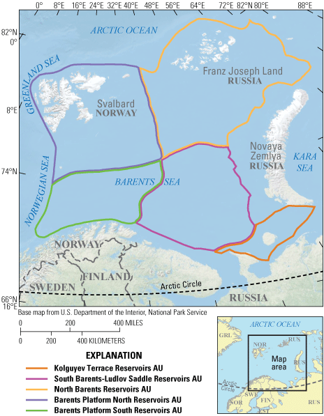
Map showing the location of five conventional assessment units (AUs) of the Barents Sea area assessed in this study.
Table 1.
Key input data for five conventional oil and gas assessment units in the Barents Sea area.[Shading indicates not applicable. AU, assessment unit; MMBO, million barrels of oil; BCFG, billion cubic feet of gas]
Total Petroleum System and Assessment Units
The USGS defined a Paleozoic–Mesozoic Composite Total Petroleum System (TPS) and five geologic assessment units (AUs) within it. Each AU was assessed for undiscovered resources of conventional oil, gas, and natural gas liquids. The Paleozoic–Mesozoic Composite TPS encompasses thermogenic gas from Carboniferous and possibly Permian coal beds and marine shales and oil and gas from organic-rich Triassic, Jurassic, and Cretaceous marine shales (van Koeverden and others, 2010). In the eastern part of the Barents Sea area, deep burial caused all source rocks to pass the thermal window for oil generation and into the thermal window for gas generation. In the western part of the Barents Sea area, source rocks are in the thermal windows for oil and gas generation. Triassic marine shales are hundreds of meters of thick and have total organic carbon (TOC) values up to 12 weight percent, hydrogen index values up to 600 milligrams hydrocarbon per gram of TOC, making them the most viable source rocks in the east (Klett, 2017). Jurassic organic-rich shales are interpreted as the most viable source rocks in the western part of the Barents Sea area (Doré, 1995; Ohm and others, 2008). Additionally, coal beds are interpreted to be a significant source for gas in this assessment, particularly in the east.
The geologic model for the Kolguyev Terrace Reservoirs AU, the South Barents-Ludlov Saddle Reservoirs AU, and the North Barents Reservoirs AU is for oil and gas generated during deep burial in the Permian to Cretaceous to have migrated into a spectrum of sandstone reservoirs within anticlines and other types of folds, faulted anticlines, and stratigraphic traps ranging from shelf to slope, as well as basin floor fans. Salt movement may have resulted in trapping configurations for oil and gas. Many large structures remain untested in these AUs (Doré, 1995). The geologic model for the Barents Platform North Reservoirs AU and the Barents Platform South Reservoirs AU is for oil and gas generated from Carboniferous coal beds and Permian, Triassic, and Jurassic marine shales to have migrated eastward into similar traps as in the east. The western part of the Barents Sea area has undergone several phases of uplift and erosion (Lerch and others, 2016), the most recent being associated with the Neogene opening of the Norwegian Sea. Uplift in the western part of the Barents Sea area in the Neogene may have resulted in erosion of reservoir intervals and may have resulted in remigration or loss of oil and gas from existing traps (Ohm and others, 2008). For readers interested in potential oil and gas resources within the Arctic region, the AUs defined and assessed in this study are entirely north of the Arctic Circle.
Undiscovered Resources Summary
The USGS quantitatively assessed undiscovered conventional oil, gas, and natural gas liquids resources within five geologic AUs of the Barents Sea area (table 2). The fully risked mean totals are 7,252 million barrels of oil (MMBO), or 7.3 billion barrels, with a F95–F5 fractile range from 1,647 to 19,210 MMBO; 463,712 billion cubic feet of gas (BCFG), or 463.7 trillion cubic feet, with an F95–F5 range from 101,255 to 1,129,949 BCFG; and 1,090 million barrels of natural gas liquids (MMBNGL), or 1.1 billion barrels, with an F95–F5 range from 269 to 2,627 MMBNGL. Most of the undiscovered oil (93 percent) and gas (98 percent) is estimated to be within the eastern part of the Barents Sea area.
Table 2.
Results for five conventional oil and gas assessment units in the Barents Sea area.[Results shown are fully risked estimates. F95 represents a 95-percent chance of at least the amount tabulated; other fractiles are defined similarly. Shading indicates not applicable. MMBO, million barrels of oil; BCFG, billion cubic feet of gas; NGL, natural gas liquids; MMBNGL, million barrels of natural gas liquids]
For More Information
Assessment results are also available at the USGS Energy website, at https://www.usgs.gov/programs/energy-resources-program.
References Cited
Gac, S., Hansford, P.A., and Faleide, J.I., 2018, Basin modeling of the SW Barents Sea: Marine and Petroleum Geology, v. 95, p. 167–187. [Also available at https://doi.org/10.1016/j.marpetgeo.2018.04.022.]
Gac, S., Klitzke, P., Minakov, A., Faleide, J.I., and Scheck-Wenderoth, M., 2016, Lithospheric strength and elastic thickness of the Barents Sea and Kara Sea Region: Tectonophysics, v. 691A, p. 120–132. [Also available at https://doi.org/10.1016/j.tecto.2016.04.028.]
Khlebnikov, P.A., Belenky, V.Y., Peshkova, I.N., Kazanin, G.S., Shkarubo, S.I., Pavlov, S.P., and Shlykova, V.V., 2011, Geological structure and petroleum potential of the east flank of the Northern Barents Basin, chap. 16 of Spencer, A.M., Embry, A.F., Gautier, D.L., Stoupakova, A.V., and Sørensen, K., eds., Arctic Petroleum Geology: Geological Society of London Memoir, No. 35, p. 260–269. [Also available at https://doi.org/10.1144/M35.16.]
Klett, T.R., 2017, Geology and assessment of undiscovered oil and gas resources of the East Barents Basins Province and the Novaya Zemlya Basins and Admiralty Arch Province, 2008, chap. O of Moore, T.E., and Gautier, D.L., eds., The 2008 Circum-Arctic Resource Appraisal: U.S. Geological Survey Professional Paper 1824, 27 p. [Also available at https://doi.org/10.3133/pp1824O.]
Klitzke, P., Faleide, J.I., Scheck-Wenderoth, M., and Sippel, J., 2015, A lithospheric-scale structural model of the Barents Sea and Kara Sea Region: Solid Earth, v. 6, no. 1, p. 153–172. [Also available at https://doi.org/10.5194/se-6-153-2015.]
Klitzke, P., Sippel, J., Faleide, J.I., and Scheck-Wenderoth, M., 2016, A 3D gravity and thermal model for the Barents Sea and Kara Sea: Tectonophysics 684, p. 131–147. [Also available at https://doi.org/10.1016/j.tecto.2016.04.033.]
Lerch, B., Karlsen, D.A., Abay, T.B., Duggan, D., Seland, R., and Backer-Owe, K., 2016, Regional petroleum alteration trends in Barents Sea oils and condensates as a clue to migration regimes and processes: AAPG Bulletin, v. 100, no. 2, p. 165–190. [Also available at https://doi.org/10.1306/08101514152.]
Mattos, N.W., Alves, T.M., and Omosanya, K.O., 2016, Crestal fault geometries reveal late halokinesis and collapse of the Samson Dome, northern Norway—Implications for petroleum systems in the Barents Sea: Tectonophysics 690, p. 76–96. [Also available at https://doi.org/10.1016/j.tecto.2016.04.043.]
Müller, R., Klausen, T.G., Faleide, J.I., Olaussen, S., Eide, C.H., and Suslova, A., 2019, Linking regional unconformities in the Barents Sea to compressional-induced forebulge uplift at the Triassic–Jurassic transition: Tectonophysics 765, p. 35–51. [Also available at https://doi.org/10.1016/j.tecto.2019.04.006.]
Ohm, S.E., Karlsen, D.A., and Austin, T.J.F., 2008, Geochemically driven exploration models in uplifted areas–Examples from the Norwegian Barents Sea: AAPG Bulletin, v. 92, no. 9, p. 1191–1223. [Also available at https://doi.org/10.1306/06180808028.]
Schenk, C.J., 2023, USGS National and Global Oil and Gas Assessment Project—Barents Sea Area, assessment unit boundaries, assessment input data, and fact sheet data tables: U.S. Geological Survey data release, available at https://doi.org/10.5066/P9L0W7ST.
van Koeverden, J.H., Nakrem, H.A., and Karlsen, D.A., 2010, Migrated oil on Novaya Zemlya, Russian Arctic—Evidence for a novel petroleum system in the eastern Barents and the Kara Sea: AAPG Bulletin, v. 94, no. 6, p. 791–817. [Also available at https://doi.org/10.1306/10200909146.]
Suggested Citation
Schenk, C.J., Mercier, T.J., Woodall, C.A., Ellis, G.S., Finn, T.M., Le, P.A., Marra, K.R., Leathers-Miller, H.M., and Drake, R.M., II, 2023, Assessment of undiscovered conventional oil and gas resources of the Barents Sea area, 2021: U.S. Geological Survey Fact Sheet 2023–3019, 2 p., http://doi.org/10.3133/fs20233019.
ISSN: 2327-6932 (online)
Study Area
| Publication type | Report |
|---|---|
| Publication Subtype | USGS Numbered Series |
| Title | Assessment of undiscovered conventional oil and gas resources of the Barents Sea area, 2021 |
| Series title | Fact Sheet |
| Series number | 2023-3019 |
| DOI | 10.3133/fs20233019 |
| Year Published | 2023 |
| Language | English |
| Publisher | U.S. Geological Survey |
| Publisher location | Reston VA |
| Contributing office(s) | Central Energy Resources Science Center |
| Description | Report: 2 p.; Data Release |
| Country | Norway, Russia |
| Other Geospatial | Barents Sea |
| Online Only (Y/N) | Y |
| Google Analytic Metrics | Metrics page |