

Assessment of Continuous Oil and Gas Resources in the Upper Jurassic Smackover Formation of the Onshore U.S. Gulf Coast, 2022
Links
- Document: Report (960 kB pdf) , HTML , XML
- Data Release: USGS data release— USGS Gulf Coast Geologic Energy Assessments and Research Project-Upper Jurassic Smackover Formation Continuous Resources: Assessment Unit Boundaries, Assessment Input Data, and Fact Sheet Data Tables
- Download citation as: RIS | Dublin Core
Abstract
Using a geology-based assessment methodology, the U.S. Geological Survey estimated undiscovered, technically recoverable mean continuous resources of 0.8 billion barrels of oil and 16 trillion cubic feet of gas in the Upper Jurassic Smackover Formation of the onshore U.S. Gulf Coast region.
Introduction
The U.S. Geological Survey (USGS) assessed undiscovered, technically recoverable, continuous (unconventional) oil and gas resources in the Smackover Formation, which extends across the Gulf Coast region from the United States-Mexican border in Texas eastward to the Florida panhandle. Mudstones of the Smackover Formation are interpreted as a major petroleum source rock for the Upper Jurassic–Cretaceous–Tertiary Composite Total Petroleum System defined by the USGS in the Gulf Coast region (Warwick and others, 2007; Dubiel and others, 2010) (fig. 1).
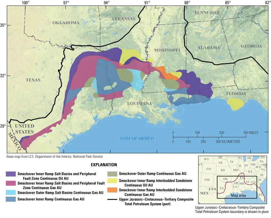
Map showing seven continuous assessment units (AUs) in the Smackover Formation within the Upper Jurassic–Cretaceous–Tertiary Total Petroleum System of the onshore Gulf Coast region.
The Smackover Formation is interpreted to have been deposited within a carbonate ramp setting, in which the ramp was a low-angle inclined carbonate surface extending from the Oxfordian shoreline to the deep basin (Mancini and others, 2019). In general, deposits of the outer ramp are mainly subtidal mudstones. Laminated mudstones within the condensed stratigraphic section of the outer ramp are commonly organic rich (Mancini and others, 2019), yet exploration of these mudstones as a self-sourced, continuous (unconventional) shale-oil or shale-gas reservoir has been limited (Yang and others, 2015). The inner-ramp facies range from similar subtidal mudstones to high-energy intertidal to supratidal carbonate facies. Most conventional oil and gas fields in the Smackover Formation are in carbonate facies of the inner-ramp environment.
The USGS defined seven continuous assessment units (AUs), five gas and two oil, within the Smackover Formation (fig. 1). Criteria used to define these AUs include the following: (1) spatial and temporal lithologic variability within the inner- and outer-ramp deposits, which affected thickness of the potential source interval; (2) presence of peripheral faults or salt basins, which may have affected petroleum migration compared to retention; (3) thermal maturity, which determined areas of oil compared to gas generation; (4) the distribution of Smackover Formation sandstones sourced from the ancestral Mississippi River (Shew and Garner, 1990), which may have provided the potential for conventional sandstone reservoirs or enhanced migration pathways through the sandstones, as well as affecting source-rock quality by dilution; and (5) maximum depth to the top of the Smackover Formation, which was 46,000 feet for this assessment. Potential gas resources at this depth are not technically recoverable using drilling and completion technologies because of high pressure and temperature conditions. Maximum temperature and pressure values used in this assessment were determined from current drilling and well-completion technologies (Wang and others, 2013; Chaplin and others, 2014; Song and Yang, 2016; Cameron, 2017), which limit the downdip extent of USGS conventional and continuous AU boundaries. This depth cutoff honors the requirement that the USGS assess only technically recoverable oil and gas resources as defined at the time of the assessment.
Total Petroleum System and Assessment Units
The USGS defined seven continuous assessment units within the Smackover Formation (table 1). In addition to the criteria described in the “Introduction” section of this report, the five continuous gas AUs were partly defined by the modeled greater than 1.3 percent equivalent vitrinite reflectance (Roe) thermal maturity contour and either the modeled 230 degrees Celsius temperature contour for technically recoverable resources or the 25,000 pound per square inch cutoff for technically recoverable resources (whichever is furthest inboard from the current coastline). More specifically, the Smackover Outer Ramp Continuous Gas AU was also defined by the extent of the outer-ramp depositional environment (Snedden and Galloway, 2019) and the areas outside of salt basins (Salvador, 1991). The Smackover Outer Ramp Salt Basins Continuous Gas AU was also defined by the extent of the outer-ramp depositional environment (Snedden and Galloway, 2019) and the extent of salt basins (Salvador, 1991). The Smackover Inner Ramp Continuous Gas AU was constrained by the extent of the inner-ramp depositional environment (Snedden and Galloway, 2019) and ramp areas outside of salt basins (Salvador, 1991). The Smackover Inner Ramp Salt Basins and Peripheral Fault Zone Continuous Gas AU was defined by the United States-Mexican border, the extent of the inner-ramp depositional environment (Snedden and Galloway, 2019), and the locations of salt basins (Salvador, 1991). The Smackover Inner Ramp Interbedded Sandstone Continuous Gas AU was constrained by the extent of the inner-ramp depositional environment (Snedden and Galloway, 2019) and the area of sandstone deposition in parts of northern Louisiana, central Mississippi, southern Alabama, and the westernmost part of the Florida panhandle.
Table 1.
Key input data for seven continuous oil and gas assessment units in the Smackover Formation.[The average estimated ultimate recovery (EUR) input is the minimum, median, maximum, and calculated mean. Gray shading indicates not applicable. AU, assessment unit; %, percent; MMBO, million barrels of oil; BCFG, billion cubic feet of gas]
The two continuous oil AUs were partly defined by the area between the 0.6 and 1.3 percent Roe thermal maturity boundaries for oil and gas, respectively. In addition, the Smackover Inner Ramp Salt Basins and Peripheral Fault Zone Continuous Oil AU was defined by the United States-Mexican border, the extent of the inner-ramp depositional environment (Snedden and Galloway, 2019), and the locations of salt basins and the peripheral fault zone (Salvador, 1991). The Smackover Inner Ramp Interbedded Sandstone Continuous Oil AU was constrained by the extent of the inner-ramp depositional environment (Snedden and Galloway, 2019) and the area of sandstone deposition within the Smackover Formation in parts of northern Louisiana, central Mississippi, southern Alabama, and the westernmost part of the Florida panhandle.
Assessment input data are summarized in table 1 and in Schenk and Whidden (2023). Across the U.S. Gulf Coast, 41 wells have targeted the lower part of the Smackover Formation (S&P Global Commodity Insights, 2023), and of these, only 3 wells have sufficient production data to calculate estimated ultimate recoveries (EURs). For this reason, input data from USGS continuous oil and gas resource assessments of Upper Jurassic strata in northeast Mexico (Schenk and others, 2014) were used as guides for potential EUR distributions in the Smackover Formation.
Undiscovered Resources Summary
The USGS quantitatively assessed oil and gas resources in seven continuous AUs in the Smackover Formation (table 2). For undiscovered, technically recoverable continuous oil and gas resources, the mean totals are 799 million barrels of oil (MMBO), or 0.8 billion barrels of oil, with an F95 to F5 fractile range from 177 to 1,789 MMBO; 15,958 billion cubic feet of gas (BCFG), or 16 trillion cubic feet of gas, with an F95 to F5 fractile range from 2,456 to 47,809 BCFG; and 1,122 million barrels of natural gas liquids (MMBNGL), or 1.1 billion barrels, with an F95 to F5 fractile range from 172 to 3,360 MMBNGL.
Table 2.
Results for seven continuous assessment units in the Smackover Formation.[Results shown are fully risked estimates. F95 represents a 95-percent chance of at least the amount tabulated; other fractiles are defined similarly. Gray shading indicates not applicable. MMBO, million barrels of oil; BCFG, billion cubic feet of gas; NGL, natural gas liquids; MMBNGL, million barrels of natural gas liquids]
References Cited
Cameron, 2017, Surface systems technology brochure: SLB website, 78 p., accessed July 1, 2022, at https://www.slb.com/-/media/files/sur/brochure/surface-overview-br.ashx.
Chaplin, A., Clemensen, P., Duckworth, C., and Warmington, K., 2014, Improved temperature performance of Poly-Aryl-Ether-Ketone polymers for use in HPHT conditions in Offshore Technology Conference, May 2014, Houston, Tex., Proceedings: Offshore Technology Conference, Paper OTC-25212-MS, accessed July 1, 2022, at https://doi.org/10.4043/25212-MS.
Dubiel, R.F., Warwick, P.D., Biewick, L., Burke, L., Coleman, J.L., Dennen, K.O., Doolan, C., Enomoto, C.B., Hackley, P.C., Karlsen, A.W., Merrill, M., Pearson, K., Pearson, O.N., Pitman, J.K., Pollastro, R.M., Rowan, E.L., Swanson, S.M., and Valentine, B.J., 2010, Geology and assessment of undiscovered oil and gas resources in Mesozoic (Jurassic and Cretaceous) rocks of the onshore and state waters of the Gulf of Mexico Region, U.S.A.: Gulf Coast Association of Geological Societies Transactions, v. 60, p. 207–216.
Mancini, E.A., Benson, D.J., Tew, B.H., Cemen, I., and Owen, A.E., 2019, Depositional model for lithofacies of the Upper Jurassic Smackover Formation in the Conecuh embayment, northeastern Gulf of Mexico—Implications for petroleum exploration: Gulf Coast Association of Geological Societies Journal, v. 8, p. 89–103, accessed July 1, 2022, at http://www.gcags.org/Journal/2019.GCAGS.Journal/2019.GCAGS.Journal.v8.07.p89-103.Mancini.et.al.pdf.
S&P Global Commodity Insights, 2023, Enerdeq US well history and production: Englewood, Colo., S&P Global Commodity Insights, accessed on January 30, 2023, at https://spglobal.com/commodityinsights. [Available from S&P Global Commodity Insights, 15 Inverness Way East, Englewood, CO 80112.]
Salvador, A., 1991, Triassic–Jurassic, in Salvador, A., ed., The Gulf of Mexico Basin: Boulder, Colo., Geological Society of America, The Geology of North America, v. J, p. 131–180, accessed July 1, 2022, at https://doi.org/10.1130/DNAG-GNA-J.389.
Schenk, C.J., and Whidden, K.J., 2023, USGS Gulf Coast Geologic Energy Assessments and Research Project, Upper Jurassic Smackover Formation continuous resources—assessment unit boundaries, assessment input data, and fact sheet data tables: U.S. Geological Survey data release, https://doi.org/10.5066/P9VUEV4S.
Schenk, C.J., Charpentier, R.R., Klett, T.R., Tennyson, M.E., Gaswirth, S.B., Brownfield, M.E., Pawlewicz, M.J., and Weaver, J.N., 2014, Assessment of unconventional oil and gas resources of Northeast Mexico, 2014: U.S. Geological Survey Fact Sheet 2014–3047, 4 p., accessed July 1, 2022, at https://doi.org/10.3133/fs20143047.
Shew, R.D., and Garner, M.M., 1990, Reservoir characteristics of nearshore shelf sandstones in the Jurassic Smackover Formation, Thomasville Field, Mississippi, chap. 18 of Barwis, J., McPherson, B., and Studlick, J., eds., Sandstone Petroleum Reservoirs: New York, N.Y., Springer-Verlag, p. 437–464, accessed July 1, 2022, at https://link.springer.com/book/10.1007/978-1-4613-8988-0.
Snedden, J.W., and Galloway, W.E., 2019, The Gulf of Mexico sedimentary basin—Depositional evolution and petroleum applications: Cambridge University Press, London, 326 p., accessed July 1, 2022, at https://doi.org/10.1017/9781108292795.
Song, L., and Yang, Z., 2016, Synthetic polymer fracturing fluid for ultrahigh temperature applications—International Petroleum Technology Conference, Bangkok, Thailand, November 14–16, 2016: International Petroleum Technology Conference, paper IPTC-18597, accessed July 1, 2022, at https://doi.org/10.2523/IPTC-18597-MS.
Warwick, P.D., Coleman, J.L., Hackley, P.C., Hayba, D.O., Karlsen, A.W., Rowan, E.L., and Swanson, S.M., 2007, USGS assessment of undiscovered oil and gas resources in Paleogene strata of the U.S. Gulf of Mexico coastal plain and State waters, in Kennen, L., Pindell, J., and Rosen, N.C., eds., The Paleogene of the Gulf of Mexico and Caribbean basins—Processes, events and petroleum systems: Society for Sedimentary Geology, v. 27, accessed July 1, 2022 at https://doi.org/10.5724/gcs.07.27.0002.
Yang, B., Gerdes, R.G., and Choi, J., 2015, The newly emerging Lower Smackover (brown dense) Formation–Its geologic characteristics and exploration potential—Unconventional Resources Technology Conference, San Antonio, Tex., July 20–22, 2015: SEG Global Meeting Abstracts, paper URTeC 2150052, p. 714–721, accessed July 1, 2022, at https://doi.org/10.15530/urtec-2015-2150052.
Suggested Citation
Whidden, K.J., Birdwell, J.E., Gardner, R.D. Kinney, S.A., Paxton, S.T., Pitman, J.K., and Schenk, C.J., 2023, Assessment of continuous oil and gas resources in the Upper Jurassic Smackover Formation of the onshore U.S. Gulf Coast, 2022: U.S. Geological Survey Fact Sheet, 2023–3021, 4 p., https://doi.org/10.3133/fs20233021.
ISSN: 2327-6932 (online)
Study Area
| Publication type | Report |
|---|---|
| Publication Subtype | USGS Numbered Series |
| Title | Assessment of continuous oil and gas resources in the Upper Jurassic Smackover Formation of the onshore U.S. Gulf Coast, 2022 |
| Series title | Fact Sheet |
| Series number | 2023-3021 |
| DOI | 10.3133/fs20233021 |
| Year Published | 2023 |
| Language | English |
| Publisher | U.S. Geological Survey |
| Publisher location | Reston VA |
| Contributing office(s) | Central Energy Resources Science Center |
| Description | Report: 4 p.; Data Release |
| Country | United States |
| State | Alabama, Arkansas, Florida, Louisiana, Mississippi, Texas |
| Online Only (Y/N) | Y |
| Google Analytic Metrics | Metrics page |